


Get to know Lianyun District
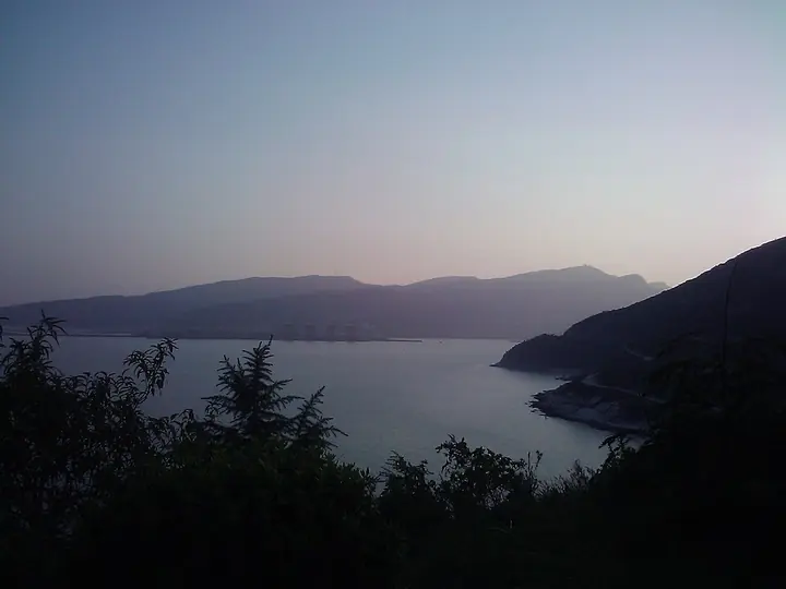
Photo adjustments
Full frame retained; proportionally resized and converted to WebP. No retouching or changes to the photographed subject. Card displays may crop the view.
- Administrative area
- District · 市辖区
- Part of
- Lianyungang
- Chinese name
- 连云区
- Local areas
- District guide
Area & population
- Area in the source
- 836.00 km²
- Population · 2014
- 250,000
Source: cited geographic source, as of the dates shown.
Setting and landscape
Most of the district is hill country formed by Rear Yuntai Mountain, Beigu Mountain and East-West Lian Island, highest in the middle and falling away on every side. It lies on the southern edge of the warm temperate zone, with a monsoon maritime climate grading towards the subtropics. The district government gives a coastline of 102.3 kilometres, and names the neighbouring Haizhou Bay fishing ground as one of China's eight well-known fisheries; the district farms 'tiaoban' laver (条斑紫菜), a seaweed, and the offshore Qiansan Islands (前三岛) are described as Jiangsu's only base for sea delicacies.
History
The port began in 1933, when the Longhai Railway administration opened a harbour at the fishing village of Laoyao (老窑) on Haizhou Bay. Because the harbour lay between Lian Island and Yuntai Mountain, it was named Lianyungang. The railway reached the quay in 1935, and the station here became kilometre zero of the Longhai line. Its old station building, once the offices of the railway's port bureau and of Lianyungang customs, is a Jiangsu provincial protected site and has served as a railway history museum since October 2013.
What to see
Lian Island (连岛), a 5A scenic area, is named by the district government as the largest island in Jiangsu. It covers 7.57 square kilometres and stretches 9 kilometres from east to west, is about 80 percent forested, and is joined to the mainland at its western end by the West Causeway (西大堤); its seaside resort is part of the Yuntai Mountain national scenic area. Haishang Yuntaishan (海上云台山), a 4A scenic area, is listed as a national forest wellness base. The district government names Lianyun Old Street (连云老街) and Beigu Mountain Forest Park (北固山森林公园) among the sites it is developing for visitors, and points to its sandy beaches and rocky shoreline.
Getting oriented
The Longhai Railway and the Shenyang–Haikou, Changchun–Shenzhen and Lianyungang–Khorgos expressways converge on the district, and the district government lists the newly opened Qingdao–Lianyungang–Yancheng, Lianyungang–Huai'an–Yangzhou–Zhenjiang and Lianyungang–Xuzhou railways. Lianyungang Port, in the district, is a national main hub port, and National Highway 310 begins here.
Highlights
- Lian Island 连岛: 5A island, the largest in Jiangsu, joined to the mainland by the West Causeway.
- Haishang Yuntaishan 海上云台山: 4A scenic area and national forest wellness base.
- Lianyun Old Street 连云老街: Old street named by the district government among its developing attractions.
- Lianyun railway station 连云站: Kilometre zero of the Longhai Railway; the old station building is a railway history museum.
Sources for this guide
连云区 - 维基百科,自由的百科全书 · Chinese Wikipedia · CC BY-SA 4.0
连云区情概况 · Lianyun District People's Government, Lianyungang
连岛 - 维基百科,自由的百科全书 · Chinese Wikipedia · CC BY-SA 4.0
连云站 - 维基百科,自由的百科全书 · Chinese Wikipedia · CC BY-SA 4.0
Original English written from the listed sources and checked sentence by sentence against quoted extracts by a separate reviewer. Updated 2026-09-25.
Explore Lianyun District
Core places to explore, with English and Chinese names.
Places to explore around Lianyun District
Bay and coastline of Lian Island at dusk, Lianyungang · 连云港连岛海湾暮景 Photograph date recorded by the source: 4 October 2010.Lian Island连岛
Lian Island lies in Haizhou Bay and connects to Lianyungang’s eastern waterfront by a sea dyke. Its main visitor landscapes include Dashawan beach and the more enclosed Sumawan bay.
Read the place guide → AI illustration · AI 示意图(仅供参考,非该地点实拍)
Seaside Yuntai Mountain海上云台山
Sea Yuntai Mountain occupies the core of Houyuntai Mountain in Lianyun District, combining wooded slopes and rocky scenery with views toward the coast.
Read the place guide → Lianyun Old Street · 连云老街
Lianyun Old Street连云老街
Lianyun Old Street is the historic port quarter of Lianyun District, where stone lanes and commercial buildings preserve the town’s relationship with the sea and railway.
Read the place guide →Plan your visit
Getting there
Lianyun District is about 20 km in a straight line from central Lianyungang. Search for 连云区 in a map app to find stations and your accommodation.
Where to stay →Build your route
Lian Island and Seaside Yuntai Mountain are both listed here. The linked place guides have entrance and visit details.
Continue with Lianyungang →More in Lianyungang
Sources & geographic information
Administrative names and parent areas: Official geographic directory · Reference date 2026-09-06.
Some facts checked against 连云区 — Wikipedia contributors, CC BY-SA 4.0.
Some facts checked against 连岛 — Wikipedia contributors, CC BY-SA 4.0.
Some facts checked against 连云站 — Wikipedia contributors, CC BY-SA 4.0.
Photo: Lian Island · NNU-10-24100117 · NNU-10-24100117 — The_beautiful_bay_in_Lian_Island_in_China.jpg — CC BY-SA 4.0 · CC BY-SA 4.0. Full frame retained; proportionally resized and converted to WebP. No retouching or changes to the photographed subject. Card displays may crop the view.

Photo: Lianyun Old Street · Source photographer · License not provided. EXIF orientation normalized; resized without changing aspect ratio; converted to WebP. No subject edits.
Map data © OpenStreetMap contributors. Pins mark approximate centres, not entrances or boundaries.