


Get to know Xiangshui County
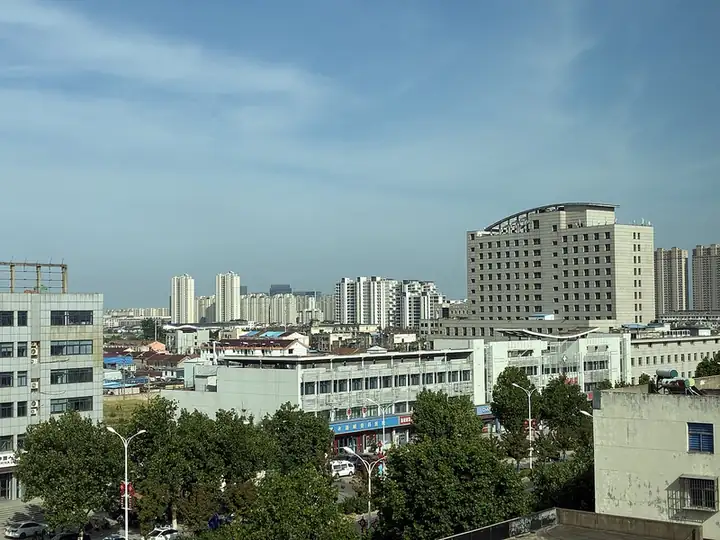
Photo adjustments
EXIF orientation normalized; resized without changing aspect ratio; converted to WebP. No subject edits.
- Administrative area
- County · 县
- Part of
- Yancheng
- Chinese name
- 响水县
- Local areas
- County guide
Area & population
- Area in the source
- 1,461.00 km²
- Population · 2018
- 600,000
Source: cited geographic source, as of the dates shown.
Setting and landscape
Rivers mark most of the border. The Guan River (灌河) runs along the north, and across the Zhongshan River (中山河) to the south lies Binhai County (滨海县); Guannan (灌南县) and Lianshui (涟水县) counties adjoin it on the west. The county government gives heights of 6 to 8 metres above sea level in the south-west, falling to about 2 metres in the north-east.
Before the Southern Song most of today's county was bay, shallow sea or tidal flat; once the Yellow River took over the Huai River's route to the sea, its silt settled here and pushed the coast steadily east.
History
The name means "sounding water". Under the Qianlong Emperor the settlement on the Guan River was called Wuji (吴集). The river bed there is steep and deep, and as the tide rose and fell its side streams dropped with a roar that could be heard several li away, so in the Jiaqing era the place became Xiangshui Kou (响水口), now Xiangshui town (响水镇), the county seat. Early in the Ming, the migration known as Hongwu Ganshan (洪武赶散) brought many settlers who lived by boiling salt and fishing. On 9 March 1966 the State Council decided to form a county from the land north of the Zhongshan River, and it was proclaimed on 1 April that year.
In 2018 the China Tian Han Research Society named the county a home of the art of short plays (小戏).
What to see
The Ancient Yunti Pass site (古云梯关遗址) in Huangxu town (黄圩镇) marks where the old Huai River once met the sea. The county government lists it as a provincial key protected heritage site and names its remains: the stone tablet carved "Gu Yunti Guan", the Xiaozi memorial arch (孝子坊), Yuwang Temple (禹王寺), the Wanghai Tower (望海楼), a horse trough and a stretch of the old Yellow River bed (黄河故道). China Jiangsu Net describes the pass as China's first customs post in history and a former hub of defence, grain shipment, water control and religion; its buildings include a Sea God Hall (海神殿).
Food and local products
Xiangshui carries the titles of China's home of shallow-water lotus root, of eucommia and of broccoli. Huangxu town grows yellow peaches, grapes, jujubes, shallow-water lotus root and dendrobium, and packages peaches, grapes and lotus root as local products.
Getting oriented
The county lies where Lianyungang (连云港), Huai'an (淮安) and Yancheng meet. National highways 204 and 228 pass through, and Xiangshui County station (响水县站) is on the Qingdao–Yancheng railway (青盐铁路).
Highlights
- Ancient Yunti Pass site 古云梯关遗址: Former mouth of the old Huai River in Huangxu town; a provincial key protected heritage site with a stone tablet, Yuwang Temple and the Wanghai Tower.
- Old Yellow River course 黄河故道: Former bed of the Yellow River, listed among the remains at the Yunti Pass site.
- Shallow-water lotus root 浅水藕: Xiangshui holds the title of China's home of shallow-water lotus root; Huangxu packages it as a local product.
Sources for this guide
响水概况 · Xiangshui County People's Government
盐城响水县黄圩镇:农旅融合扮靓特色乡村 · China Jiangsu Net (中国江苏网)
响水县 · Wikipedia (Chinese) · CC BY-SA 4.0
Original English written from the listed sources and checked sentence by sentence against quoted extracts by a separate reviewer. Updated 2026-09-25.
Explore Xiangshui County
Core places to explore, with English and Chinese names.
Xiangshui County 响水县
Plan your visit
Getting there
Xiangshui County is about 100 km in a straight line from central Yancheng. Search for 响水县 in a map app to find stations and your accommodation.
Where to stay →More in Yancheng
Sources & geographic information
Administrative names and parent areas: Official geographic directory · Reference date 2026-09-06.
Some facts checked against 响水县 — Wikipedia contributors, CC BY-SA 4.0.
Map data © OpenStreetMap contributors. Pins mark approximate centres, not entrances or boundaries.