


Get to know Ganxian District
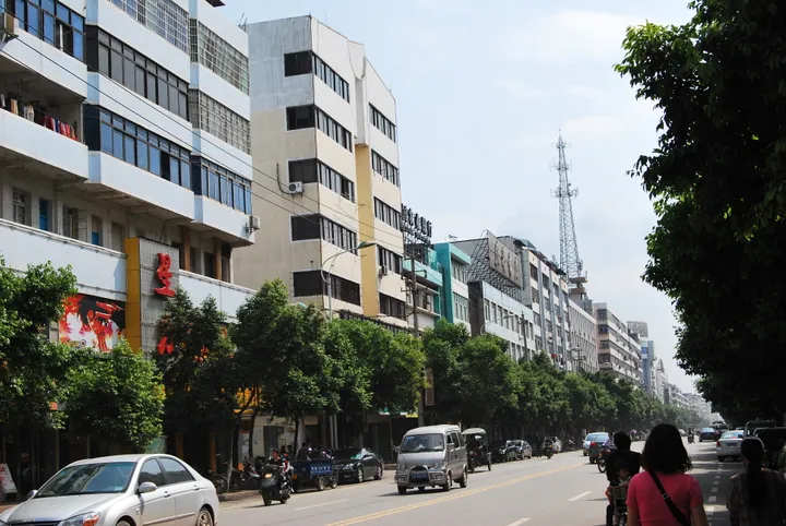
Photo adjustments
Full frame retained; proportionally resized and converted to WebP. No retouching or changes to the photographed subject. Card displays may crop the view.
- Administrative area
- District · 市辖区
- Part of
- Ganzhou
- Chinese name
- 赣县区
- Local areas
- District guide
Area & population
- Area in the source
- 2,993.09 km²
- Population · 2014
- 641,677
- Administrative seat
- Meilin Town
Source: cited geographic source, as of the dates shown.
History
Ganxian was set up as a county in 201 BC under Emperor Gaozu of Han, and the district government counts it among the 18 oldest counties in Jiangxi. The name is traced to a line in the Classic of Mountains and Seas (山海经) about a "giant of Gan in the south". The county became a district of Ganzhou in October 2016. The district government calls it one of the birthplaces of Hakka culture and of Donghe opera (东河戏), and it was a county of the Central Soviet Area; General Lai Chuanzhu (赖传珠) was born here.
What to see
The district government lists Qizhen Temple (契真寺) from the Han, Chujun Temple (储君庙) from the Jin and Baohua Temple (宝华寺) from the Tang, the old village of Bailu (白鹭古村), and the Jiangxi Hakka Museum (江西客家博物院), which it describes as the province's first museum devoted to Hakka folk culture. Natural sights include Baolian Mountain (宝莲山), Taohua Island (桃花岛), Xiangyun Lake (祥云湖) and the Danxia landforms of Zhaijiu'ao (寨九坳).
Xiafu (夏府村), in Hujiang (湖江镇) on the west bank of the Gan, is a peninsula with water on three sides. It lies between Tianzhu and Hengxian, the two most dangerous of the Gan's Eighteen Rapids (十八滩), where boats unloaded their cargo to be carried past, and by the mid-Ming it was a market town. Its ancestral halls include the Qi clan's main hall, founded in the Ming and rebuilt in 1906, with 18 red stone pillars and an opera stage, and the Xie clan hall. An old post road more than 200 metres long still runs through the village, which is a Jiangxi historic and cultural village and on the list of Chinese traditional villages.
Food and local products
Huangyuan rice cake (黄元米果) is a Hakka winter food that, by local tradition, was listed as a local tribute in the Ming. Made the traditional way, rice is soaked overnight in lye water filtered from the ash of huangyuan wood (黄元柴), steamed, mixed with more lye water, dried and steamed again, then pounded in a stone mortar with a hardwood pole and cut into shapes. The cakes are yellow and are kept under lye water in jars until the following summer. Chinese Wikipedia notes that Ganxian is known as China's home of pressed salted duck (板鸭).
Highlights
- Xiafu village 夏府村: Gan River village between two of the Eighteen Rapids, with Ming-founded clan halls and an old post road.
- Jiangxi Hakka Museum 江西客家博物院: Described as the province's first museum devoted to Hakka folk culture.
- Zhaijiu'ao 寨九坳: Area of Danxia landforms named by the district government.
- Huangyuan rice cake 黄元米果: Rice cake made with lye water from huangyuan wood ash, pounded and stored in jars.
Sources for this guide
赣县区 - 维基百科,自由的百科全书 · Chinese Wikipedia · CC BY-SA 4.0
赣县区区情简介 | 赣县区人民政府 · Ganxian District People's Government
历史沿革 | 赣县区人民政府 · Ganxian District People's Government
赣县夏府村倚江千载古为“客家南迁中转站” | 赣县区人民政府 · Ganxian District People's Government
黄元米果 | 赣县区人民政府 · Ganxian District People's Government
Original English written from the listed sources and checked sentence by sentence against quoted extracts by a separate reviewer. Updated 2026-09-25.
Explore Ganxian District
Core places to explore, with English and Chinese names.
Ganxian District 赣县区
Plan your visit
Getting there
Ganxian District is about 15 km in a straight line from central Ganzhou. Search for 赣县区 in a map app to find stations and your accommodation.
Where to stay →More in Ganzhou
Sources & geographic information
Administrative names and parent areas: Official geographic directory · Reference date 2026-09-06.
Some facts checked against 赣县区 — Wikipedia contributors, CC BY-SA 4.0.
Map data © OpenStreetMap contributors. Pins mark approximate centres, not entrances or boundaries.