


Get to know Chongyi County
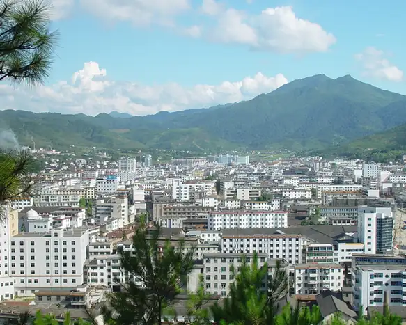
Photo adjustments
EXIF orientation normalized; resized without changing aspect ratio; converted to WebP. No subject edits.
- Administrative area
- County · 县
- Part of
- Ganzhou
- Chinese name
- 崇义县
- Local areas
- County guide
Area & population
- Area in the source
- 2,206.27 km²
- Population · 2010
- 187,234
Source: cited geographic source, as of the dates shown.
Setting and landscape
The land falls from the southwest to the northeast. Qiyun Mountain (齐云山), at 2,061.3 m in Sishun township (思顺乡), is the highest point in the county and in southern Jiangxi, and 232 peaks top 1,000 m. The rivers belong to the Gan River system and feed the Zhang River (章水); the main ones are the Dajiang, Xiaojiang and Yangmei rivers. The county government puts forest cover at 88.3 percent and calls the county Jiangxi's green treasure house, with ginkgo, southern yew and dawn redwood among its protected trees.
History
The county government dates Chongyi's founding to the winter of 1517, after the Ming official Wang Shouren (王守仁), better known as Wang Yangming, put down the uprising of Xie Zhishan (谢志山) and Lan Tianfeng (蓝天凤) at Hengshui (横水) and Tonggang (桶冈). Land was taken from Shangyou (上犹), Nankang (南康) and Dayu (大余), the seat was placed at Hengshui, and the county was named after Chongyi ward. In late 1927 Zhu De (朱德) and Chen Yi (陈毅) retrained the remnants of the Nanchang Uprising force at Shangbao, and in 1931 a soviet government was set up in the county.
What to see
The Shangbao Hakka terraces (上堡梯田) in Shangbao township, 50 km from the county town, are a national 4A scenic area and are listed by the UN Food and Agriculture Organization as a Globally Important Agricultural Heritage System; the county government calls them one of China's three great terrace landscapes. The site of the Shangbao retraining is also in the township. Jiangxi Yangming Mountain National Forest Park (阳明山国家森林公园), where Hunan, Guangdong and Jiangxi meet, was once called Guanyin Mountain (观音山); it was renamed Yangling (阳岭) in memory of Wang Yangming and took its present name in January 2017. Chinese Wikipedia also lists the Pingchaliao (平茶寮) inscription, a Ming cliff carving.
Food and local products
Chongyi calls itself China's home of bamboo and of the Chinese hog plum (南酸枣). Shangbao township grows selenium-rich rice and tea, including the high-mountain Chishuixian (赤水仙) tea.
Highlights
- Shangbao terraces 上堡梯田: Hakka rice terraces listed as a Globally Important Agricultural Heritage System; national 4A scenic area.
- Yangming Mountain National Forest Park 阳明山国家森林公园: Forest park on the Hunan–Guangdong–Jiangxi border, renamed in memory of Wang Yangming.
- Qiyun Mountain 齐云山: Highest peak in southern Jiangxi at 2,061.3 m.
Sources for this guide
自然地理 · Chongyi County People's Government
历史沿革 · Chongyi County People's Government
资源特色 · Chongyi County People's Government
上堡乡 · Chongyi County People's Government (Shangbao township page)
崇义县 · Wikipedia (Chinese) · CC BY-SA 4.0
江西阳明山国家森林公园 · Wikipedia (Chinese) · CC BY-SA 4.0
Original English written from the listed sources and checked sentence by sentence against quoted extracts by a separate reviewer. Updated 2026-09-25.
Explore Chongyi County
Core places to explore, with English and Chinese names.
Places to explore around Chongyi County
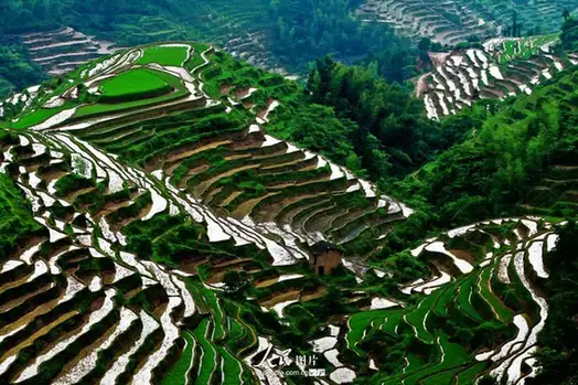 Shangbao Rice Terraces · 上堡梯田
Shangbao Rice Terraces上堡梯田
The Shangbao terraces (上堡梯田) are a system of hillside rice terraces in Shangbao Township in the west of Chongyi County, southern Jiangxi, on the border with Hunan.
Read the place guide →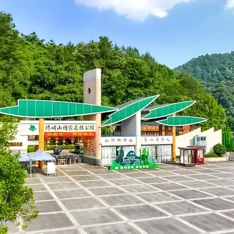 Yangmingshan National Forest Park · 阳明山国家森林公园
Yangmingshan National Forest Park阳明山国家森林公园
Yangmingshan National Forest Park (阳明山国家森林公园) is a forested upland in Chongyi County, southern Jiangxi, rising to the peak of Yangling at 1,259.5 metres.
Read the place guide →Plan your visit
Getting there
Chongyi County is about 65 km in a straight line from central Ganzhou. Search for 崇义县 in a map app to find stations and your accommodation.
Where to stay →Build your route
Shangbao Rice Terraces and Yangmingshan National Forest Park are both listed here. The linked place guides have entrance and visit details.
Continue with Ganzhou →More in Ganzhou
Sources & geographic information
Administrative names and parent areas: Official geographic directory · Reference date 2026-09-06.
Some facts checked against 崇义县 — Wikipedia contributors, CC BY-SA 4.0.
Some facts checked against 江西阳明山国家森林公园 — Wikipedia contributors, CC BY-SA 4.0.
Photo: Shangbao Rice Terraces · Source photographer · License not provided. EXIF orientation normalized; resized without changing aspect ratio; converted to WebP. No subject edits.
Photo: Yangmingshan National Forest Park · Source photographer · License not provided. EXIF orientation normalized; resized without changing aspect ratio; converted to WebP. No subject edits.
Map data © OpenStreetMap contributors. Pins mark approximate centres, not entrances or boundaries.