


Get to know Anyuan County
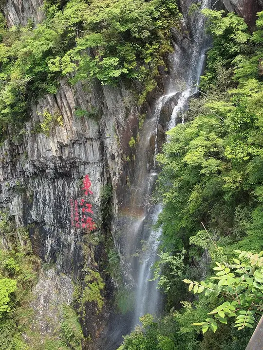
Photo adjustments
Full frame retained; resized proportionally to a maximum dimension of 960 pixels and converted to WebP quality 88. No crop, retouch, generated elements, or subject alteration. Final website rendition: full frame retained, proportionally resized to at most 720 pixels and converted to WebP. No additional retouching or subject alteration. Card displays may crop the view.
- Administrative area
- County · 县
- Part of
- Ganzhou
- Chinese name
- 安远县
- Local areas
- County guide
Area & population
- Area in the source
- 2,374.59 km²
- Population · 2012
- 382,855
Source: cited geographic source, as of the dates shown.
Setting and landscape
The county lies on an extension of the Nanling (南岭) ranges, a country of low and middle mountains and hills; mountain land makes up about 83 percent of its area. The Lian River (濂江), a tributary of the Gong (贡水), flows through it. The county lies on the upper Gan River in the Yangtze system and, at Sanbai Mountain, at the source of the Dongjiang in the Pearl River system. The seat is Xinshan town (欣山镇).
History
Anyuan was first set up in 544 under the Liang dynasty, carved from Yudu (雩都) and named after the Anyuan River, today's Lian River. It was merged back into Yudu under the Sui and re-established in 788 under the Tang. During the Land Revolution it was part of the Central Revolutionary Base Area, belonging from August 1933 to the Soviet province of Yue-Gan (粤赣省). Chinese Wikipedia names Anyuan as the birthplace of tea-picking opera (采茶戏).
What to see
Sanbai Mountain is the collective name for the peaks on Anyuan's southeastern border. It is a national scenic area, a national forest park and a national 5A scenic area with five touring zones, including Fuaotang (福鳌塘), a lake in an ancient volcanic crater at 850 m, and Dongfeng Lake (东风湖), a reservoir built in 1965 that visitors tour by boat. The Dongjiang First Waterfall (东江第一瀑) drops nearly 100 m. The Siyuan Cauldron (思源宝鼎), cast in 2007 on the model of a Western Zhou bronze, was paid for by donors from Jiangxi, Guangdong and Hong Kong. In the county town, Wuwei Temple Pagoda (无为寺塔) was built in 1097: a brick-and-timber tower of nine storeys outside and 17 floors inside, repaired in 1981 to 1984 and now 61.29 m tall. Other sights named by the county include Lianhua Cliff (莲花岩), Longquan Lake (龙泉湖) and Yongzhen Bridge (永镇桥).
Food and local products
Rice is the main crop. In the forested townships beekeeping has a long history, and shiitake, wood-ear fungus and dried bamboo shoots are traditional products. Chinese Wikipedia describes Anyuan as China's first demonstration county for pollution-free navel oranges, with a navel-orange orchard park at Dulidong (独立岽).
Highlights
- Sanbai Mountain 三百山: Source of the Dongjiang; national 5A scenic area with a crater lake and the Dongjiang First Waterfall.
- Wuwei Temple Pagoda 无为寺塔: Nine-storey brick-and-timber pagoda of 1097 in the county town, 61.29 m tall after repair.
- Fuaotang 福鳌塘: Lake in an ancient volcanic crater at 850 m on Sanbai Mountain.
- Anyuan navel oranges 安远脐橙: The county was China's first demonstration county for pollution-free navel oranges.
Sources for this guide
安远县情 · Anyuan County People's Government
历史沿革 · Anyuan County People's Government
文化名胜 · Anyuan County People's Government
风土人情 · Anyuan County People's Government
三百山国家级风景名胜区 · Anyuan County People's Government
地理位置 · Anyuan County People's Government
安远县 · Wikipedia (Chinese) · CC BY-SA 4.0
Original English written from the listed sources and checked sentence by sentence against quoted extracts by a separate reviewer. Updated 2026-09-25.
Explore Anyuan County
Core places to explore, with English and Chinese names.
Places to explore around Anyuan County
 Anyuan Sanbai Mountain (安远三百山), Anyuan County. Photograph: "Mount Sanbai, source of the Dongjiang River".
Anyuan Sanbai Mountain安远三百山
Sanbai Mountain is a forested mountain area in southeastern Anyuan associated with the headwaters of the Dongjiang River.
Read the place guide →Sanbai Mountains (三百山), Anyuan County. Photograph: "Mount Sanbai, source of the Dongjiang River".Sanbai Mountains三百山
Forested range in Anyuan County, Ganzhou, Jiangxi, at the source of the Dong River that supplies Hong Kong, with a crater lake, waterfalls and plank roads.
Read the place guide →Plan your visit
Getting there
Anyuan County is about 80 km in a straight line from central Ganzhou. Search for 安远县 in a map app to find stations and your accommodation.
Where to stay →Build your route
Anyuan Sanbai Mountain and Sanbai Mountains are both listed here. The linked place guides have entrance and visit details.
Continue with Ganzhou →More in Ganzhou
Sources & geographic information
Administrative names and parent areas: Official geographic directory · Reference date 2026-09-06.
Some facts checked against 安远县 — Wikipedia contributors, CC BY-SA 4.0.
Photo: Anyuan Sanbai Mountain · Underbar dk · CC BY-SA 4.0. Full frame retained; EXIF orientation normalized, proportionally resized to at most 800 pixels and converted to WebP. No generated pixels or subject changes. Cards may crop the display.

Photo: Sanbai Mountains · Underbar dk · CC BY-SA 4.0. Full frame retained; EXIF orientation normalized, proportionally resized to at most 800 pixels and converted to WebP. No generated pixels or subject changes. Cards may crop the display.
Map data © OpenStreetMap contributors. Pins mark approximate centres, not entrances or boundaries.