


Get to know Xiajiang County
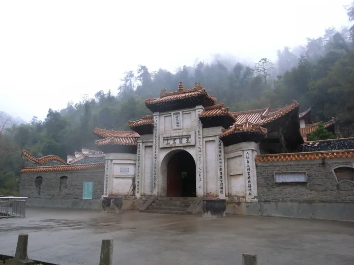
Photo adjustments
Full frame retained; proportionally resized and converted to WebP. No retouching or changes to the photographed subject. Card displays may crop the view.
- Administrative area
- County · 县
- Part of
- Ji'an
- Chinese name
- 峡江县
- Local areas
- County guide
Setting and landscape
The Gan flows north through the middle of the county for 38 kilometres, splitting it into east and west halves; south of Bajiu the river is only 400 metres wide, which the county government calls the narrowest point on its course, and the Xiajiang Water Control Project, built for flood control and power, stands there. The land rises toward the south-east and north-west. Wuduomeihua peak (五朵梅花) in Tonglin (桐林), at 644 metres, is the highest point, and the Gan valley at Renhe (仁和), at 26 metres, the lowest. Hills cover about 62 per cent of the county. The Yi (沂江), Huangjin (黄金江) and Panlong (盘龙江) rivers are the main tributaries.
History
The kingdom of Wu set up Bajiu County here in 267; it was abolished in 590, and Xiajiang County itself dates from 1526 under the Ming. The county seat stood at Bajiu on the west bank until 1 July 1997, when it moved to Shuibian (水边镇), 20 kilometres east of the river. A bridge over the Gan, opened in July 2004, joins the two halves.
What to see
Yusi Mountain (玉笥山), 2.5 kilometres south-west of the new county town, is counted in Daoist tradition as the 17th grotto-heaven and 8th blessed land, and is a provincial key scenic area and provincial forest park. The Xiajiang Meeting site (峡江会议旧址) recalls the Red Army's first steps toward defeating the encirclement campaigns. The Jinmeihua scenic area (金梅花景区), newly rated a national 4A scenic area, is in Jinping Ethnic Township (金坪民族乡), which the Jiujiang culture and tourism bureau describes as Jiangxi's only multi-ethnic township, home to nine ethnic groups; visitors can try batik, old-style papermaking and ethnic songs and dances.
Food and local products
Xiajiang traditional rice noodles (峡江传统米粉), dated to the early Southern Song and sent as tribute under the Ming, entered Jiangxi's second provincial intangible heritage list in 2007. They are made from late-season rice and water from Longxia village (龙下村) through fermenting, straining, boiling, stirring and pulling, and are eaten boiled, stir-fried, steamed, deep-fried or cold. Bean-and-chilli pickle (豆角辣椒), a fixture of Xiajiang tables, is made by mixing sun-dried long beans with fresh red chillies and salt and pickling them in pottery jars.
Getting oriented
The county lies 147 kilometres south of Nanchang, the provincial capital, and 74 kilometres north of Ji'an city. The Beijing–Kowloon railway, the Jiangxi–Guangdong expressway (赣粤高速公路), National Highway 105 and the Gan River waterway run north–south through the county.
Highlights
- Yusi Mountain 玉笥山: Daoist 17th grotto-heaven and 8th blessed land; provincial key scenic area and forest park.
- Jinmeihua scenic area 金梅花景区: National 4A scenic area in the multi-ethnic Jinping township, with batik and papermaking.
- Xiajiang Water Control Project 峡江水利枢纽工程: Flood-control and power dam at the 400-metre narrows south of Bajiu.
- Xiajiang traditional rice noodles 峡江传统米粉: Late-rice noodles on Jiangxi's provincial intangible heritage list since 2007.
Sources for this guide
峡江县人民政府-峡江概况 · Xiajiang County People's Government
九江市文化广电旅游局,江西新增12家国家4A级景区! · Jiujiang Municipal Bureau of Culture, Radio, Television and Tourism
快上车,最红高铁的神秘面纱要揭开了! · Shaanxi Daily (sxdaily.com.cn)
峡江县 - 维基百科,自由的百科全书 · Wikipedia (Chinese) · CC BY-SA 4.0
Original English written from the listed sources and checked sentence by sentence against quoted extracts by a separate reviewer. Updated 2026-09-25.
Explore Xiajiang County
Core places to explore, with English and Chinese names.
Xiajiang County 峡江县
Plan your visit
Getting there
Xiajiang County is about 60 km in a straight line from central Ji'an. Search for 峡江县 in a map app to find stations and your accommodation.
Where to stay →More in Ji'an
Sources & geographic information
Administrative names and parent areas: Official geographic directory · Reference date 2026-09-06.
Some facts checked against 峡江县 — Wikipedia contributors, CC BY-SA 4.0.
Map data © OpenStreetMap contributors. Pins mark approximate centres, not entrances or boundaries.