


Get to know Jingyu County
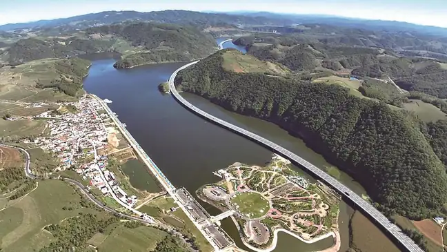
Photo adjustments
EXIF orientation normalized; resized without changing aspect ratio; converted to WebP. No subject edits.
- Administrative area
- County · 县
- Part of
- Baishan
- Chinese name
- 靖宇县
- Local areas
- County guide
Area & population
- Area in the source
- 3,094.00 km²
- Administrative seat
- Jingyu Town
Source: cited geographic source, as of the dates shown.
Getting oriented
The county is long and narrow, about 90 kilometres from north to south and 35 kilometres across. Fusong (抚松) lies to the east, Jiangyuan (江源) to the south, Huinan (辉南) and Liuhe (柳河) to the west, and Huadian (桦甸) to the north.
History
Under the Qing the area was known as Mengjiang (濛江). A land-reclamation office opened here in 1900, a Mengjiang department (州) was created in 1908, and it became Mengjiang County in 1913. Japanese troops occupied it on 17 October 1932. In February 1946 the county was renamed Jingyu, and it has been part of Baishan, first called Hunjiang city, since 1985.
The Yang Jingyu Memorial Hall (杨靖宇将军纪念馆) was first built in the county town in 1962 and moved on 15 August 1995 to the site where the general died. The county government's page on the hall pictures his wooden grave marker, a sword and a saddle he used, a map of his last marches and a tree stump that anti-Japanese fighters used for writing slogans. The site and hall became a Jilin provincial patriotic education base in 1994.
What to see
The Renyi scenic area (仁义风景区), which locals call Renyi Lazi (仁义砬子) on Baishan Lake (白山湖), is a 2A scenic area 20 kilometres from the county town in the southeast of the county. Sheer peaks up to 600 metres line the banks, and boat trips pass named rocks such as Renyi Peak (仁义峰) and Camel Peak (骆驼峰). A walking route of about 2 kilometres follows Qinghai gully (青海沟) up the Renyi gorge past the Yangguan Sandie waterfall (阳关三叠瀑布). In spring apricot blossom covers the hills, in autumn the maples turn red, and in winter the scenic area offers skating and dog sledding. Baishan Lake itself is the reservoir of the Baishan hydropower station (白山水电站) on the upper Songhua.
Highlights
- Yang Jingyu Memorial Hall 杨靖宇将军纪念馆: Moved in 1995 to the place where General Yang Jingyu died; a provincial patriotic education base since 1994.
- Renyi scenic area 仁义风景区: 2A scenic area of sheer peaks on Baishan Lake, with boat trips and a gorge walk.
Sources for this guide
自然地理 · Jingyu County People's Government
靖宇历史 · Jingyu County People's Government
杨靖宇纪念馆 · Jingyu County People's Government
仁义风景区 · Jingyu County People's Government
Jingyu County - Wikipedia · Wikipedia (English) · CC BY-SA 4.0
Original English written from the listed sources and checked sentence by sentence against quoted extracts by a separate reviewer. Updated 2026-09-25.
Explore Jingyu County
Core places to explore, with English and Chinese names.
Jingyu County 靖宇县
Plan your visit
Getting there
Jingyu County is about 30 km in a straight line from central Baishan. Search for 靖宇县 in a map app to find stations and your accommodation.
Where to stay →More in Baishan
Sources & geographic information
Administrative names and parent areas: Official geographic directory · Reference date 2026-09-06.
Some facts checked against Jingyu County — Wikipedia contributors, CC BY-SA 4.0.
Map data © OpenStreetMap contributors. Pins mark approximate centres, not entrances or boundaries.