


Get to know Liuhe County
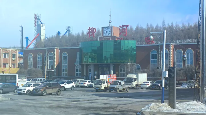
Photo adjustments
Full frame retained; proportionally resized and converted to WebP. No retouching or changes to the photographed subject. Card displays may crop the view.
- Administrative area
- County · 县
- Part of
- Tonghua
- Chinese name
- 柳河县
- Local areas
- County guide
Area & population
- Area in the source
- 3,348.00 km²
- Administrative seat
- Liuhe Town (柳河镇)
Source: cited geographic source, as of the dates shown.
Setting and landscape
The land is high in the south-east and south-west and slopes down to the north-east. Almost all of the county drains to the Huifa River (辉发河), a tributary of the Second Songhua River; only the Hani River (哈泥河) in the south-east flows to the Hun River (浑江) and the Yalu. The main rivers are the Yitong (一统河), Santong (三统河), Wuji (乌鸡河), Liangshui (凉水河) and Hani. Forest, part of the Changbai forest region, covers 54 percent of the county, and its main non-metallic deposits are limestone, basalt, peat and volcanic cinder.
History
In the early Qing the area was a sealed imperial hunting ground where settlers were barred and only tribute ginseng, game and mountain produce were gathered. From 1873 the Shengjing (盛京) military governor opened it to farming. Liuhe County was created on 4 August 1902 and named after its seat, Liuhe town, which took its name from the Liushu River (柳树河) east of the town. It came under Jilin province in 1954 and under Tonghua city in 1986.
What to see
Luotong Mountain City (罗通山城) is a national key cultural relic site, listed in 2001, on the 906-metre main peak of Luotong Mountain, 25 kilometres north-east of the county seat. Its eastern and western enclosures run about 7.8 kilometres in all, built of dressed limestone from the mountain itself or using sheer cliffs as walls. Built in the Wei and Jin period, the middle period of Goguryeo (高句丽), it has the typical features of a Goguryeo mountain fortress and remained in use under the Jurchen Jin dynasty. The county's second national site is the group of stone-slab dolmen tombs on the upper Huifa River (辉发河上游石棚墓). Luotong Mountain is also the county's only 4A scenic area, and the Shisanhu (十三户) peony valley is known for its herbaceous peonies.
Food and local products
Liuhe rice is a national regional public brand, and the county calls itself China's home of volcanic-rock rice. Wild grapes from Liuhe carry a national geographical indication, and the county makes wine from them. Forest-grown ginseng covers most of the county's ginseng fields, and the county names Yunling Wild Ginseng (云岭野山参) as the leading example among its ginseng processors. Local performing traditions include Guandong Lü opera (关东吕剧), Hui dragon lanterns and Luotong Mountain errenzhuan (二人转) duets.
Highlights
- Luotong Mountain City 罗通山城: A Goguryeo-type mountain fortress on a 906-metre peak, a national key cultural relic site since 2001.
- Liuhe wild grapes 柳河山葡萄: A Chinese geographical-indication product.
- Liuhe rice 柳河大米: Named a national regional public brand in China's agricultural brand catalogue.
Sources for this guide
柳河县 - 维基百科 · Chinese Wikipedia · CC BY-SA 4.0
自然地理 - 柳河县人民政府 · Liuhe County People's Government
历史沿革 - 柳河县人民政府 · Liuhe County People's Government
文化旅游 - 柳河县人民政府 · Liuhe County People's Government
名优特产 - 柳河县人民政府 · Liuhe County People's Government
罗通山城 - 维基百科 · Chinese Wikipedia · CC BY-SA 4.0
Original English written from the listed sources and checked sentence by sentence against quoted extracts by a separate reviewer. Updated 2026-09-25.
Explore Liuhe County
Core places to explore, with English and Chinese names.
Liuhe County 柳河县
Plan your visit
Getting there
Liuhe County is about 65 km in a straight line from central Tonghua. Search for 柳河县 in a map app to find stations and your accommodation.
Where to stay →More in Tonghua
Sources & geographic information
Administrative names and parent areas: Official geographic directory · Reference date 2026-09-06.
Some facts checked against 柳河县 — Wikipedia contributors, CC BY-SA 4.0.
Some facts checked against 罗通山城 — Wikipedia contributors, CC BY-SA 4.0.
Map data © OpenStreetMap contributors. Pins mark approximate centres, not entrances or boundaries.