


Get to know Huinan County
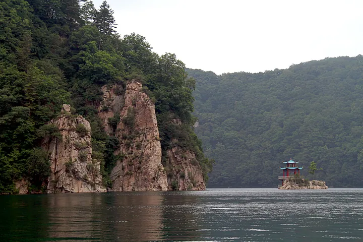
Photo adjustments
Full frame retained; proportionally resized and converted to WebP. No retouching or changes to the photographed subject. Card displays may crop the view.
- Administrative area
- County · 县
- Part of
- Tonghua
- Chinese name
- 辉南县
- Local areas
- County guide
Area & population
- Area in the source
- 2,277.00 km²
- Administrative seat
- Chaoyang (朝阳镇)
Source: cited geographic source, as of the dates shown.
Setting and landscape
The county government counts more than 70 rivers and streams and 41 reservoirs, and describes the county as lying "九河下哨" ("below the nine rivers"). Forest covers 50.8 percent of the county and more than 90 percent of the eastern hills. The county contains two reserves: the national Jilin Longwan Nature Reserve (吉林龙湾国家级自然保护区), and the provincial Dayishan Wetland Nature Reserve (大椅山湿地省级自然保护区). The ground also holds basalt, peat, iron and gold, and 60 tested mineral-water springs.
What to see
The Longwan lakes are maars, crater lakes formed by volcanic eruptions between the late Early Pleistocene and the early Middle Pleistocene. Eight lakes are called longwan ("dragon bays"); six are in Huinan. Great Longwan (大龙湾) in Jinchuan town (金川镇) is the largest, covering 81 hectares with a maximum depth of 97 metres, while Eastern Longwan (东龙湾) in Fumin town (抚民镇) is the deepest at 107 metres. Huinan's six lakes became the Jilin Longwan National Forest Park (龙湾群国家森林公园) in 1992, a national 4A scenic area in 2005, and joined the IUCN Green List of protected areas in 2015.
The Huifa city site (辉发城址) on Huifa Mountain, southwest of Huifacheng town (辉发城镇), is a national key cultural relic site. It was the royal seat of the Huifa (辉发) tribe, one of the four Hulun (扈伦) groups of the Haixi Jurchens (海西女真) in the Ming. Nurhaci (努尔哈赤) besieged it in 1607 and absorbed the Huifa tribe. Its earth-and-stone walls divide into inner, middle and outer enclosures, the inner one on the hilltop.
History and culture
The county government calls Huinan the birthplace of Huifa Manchu culture. The area was a Qing imperial hunting preserve, and the Kangxi and Qianlong emperors hunted here and wrote poems on the ruined Huifa city. Provincial intangible heritage from Huinan includes the "bawang bian" (霸王鞭, rattle-stick) dance, Huifa Manchu paper-cutting, traditional Huifa braised goose-making (辉发传统扒鹅制作技艺) and Changbai Mountain Manchu bean paste brewing. The county government also describes Huinan as the core area of Yang Jingyu's (杨靖宇) "Longgang strategic plan" for anti-Japanese resistance in southern Manchuria, and Sanjiao Longwan (三角龙湾) is a provincial patriotic education base.
Highlights
- Jilin Longwan National Forest Park 龙湾群国家森林公园: Six volcanic maar lakes in Huinan, made a forest park in 1992 and a 4A scenic area in 2005.
- Huifa city site 辉发城址: A national key cultural relic site: the hilltop seat of the Ming-era Huifa Jurchens, taken by Nurhaci in 1607.
- Huifa braised goose 辉发传统扒鹅: Its traditional making technique is on Jilin's provincial intangible heritage list.
Sources for this guide
地理位置 - 辉南县人民政府 · Huinan County People's Government
自然资源 - 辉南县人民政府 · Huinan County People's Government
历史沿革 - 辉南县人民政府 · Huinan County People's Government
吉林龙湾 - 维基百科 · Chinese Wikipedia · CC BY-SA 4.0
辉发城址 - 维基百科 · Chinese Wikipedia · CC BY-SA 4.0
Original English written from the listed sources and checked sentence by sentence against quoted extracts by a separate reviewer. Updated 2026-09-25.
Explore Huinan County
Core places to explore, with English and Chinese names.
Places to explore around Huinan County
 Longwan Crater Lakes National Forest Park (
Plan your visit
Getting there
Huinan County is about 105 km in a straight line from central Tonghua. Search for 辉南县 in a map app to find stations and your accommodation.
Where to stay →Build your route
Start with Longwan Crater Lakes National Forest Park. The linked place guides have entrance and visit details.
Continue with Tonghua →More in Tonghua
Sources & geographic information
Administrative names and parent areas: Official geographic directory · Reference date 2026-09-06.
Some facts checked against 吉林龙湾 — Wikipedia contributors, CC BY-SA 4.0.
Some facts checked against 辉发城址 — Wikipedia contributors, CC BY-SA 4.0.
Photo: Longwan Crater Lakes National Forest Park · Rolfmueller · CC BY-SA 3.0. Full frame retained; EXIF orientation normalized, proportionally resized to at most 800 pixels and converted to WebP. No generated pixels or subject changes. Cards may crop the display.

Map data © OpenStreetMap contributors. Pins mark approximate centres, not entrances or boundaries.