


Get to know Dongchang District
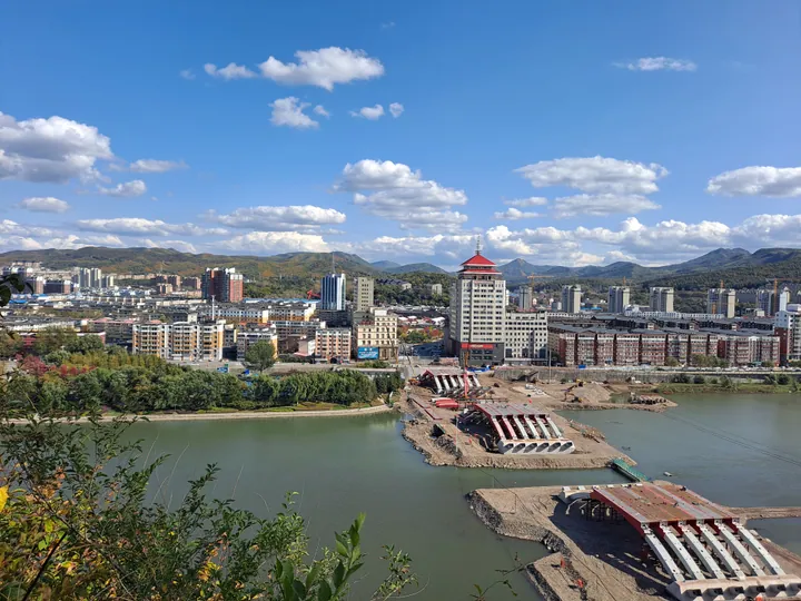
Photo adjustments
Full frame retained; proportionally resized and converted to WebP. No retouching or changes to the photographed subject. Card displays may crop the view.
- Administrative area
- District · 市辖区
- Part of
- Tonghua
- Chinese name
- 东昌区
- Local areas
- District guide
Area & population
- Area in the source
- 375.27 km²
- Population · 2020 census
- 1,812,114
- Administrative seat
- Minzhu Subdistrict
Source: cited geographic source, as of the dates shown.
Setting and history
Tonghua lies in the heart of the Changbai Mountains (长白山) on the upper Hun River, and its urban area is built on terraces along both banks. When a county was set up in 1877, its seat was at Toudaojiang (头道江), today part of Dongchang. The name Tonghua renders Tunggiya, the Manchu name of the Hun River, which was also called the Tongjia River (佟佳江) in Chinese.
What to see
Yuhuangshan Park (玉皇山公园) covers 115 hectares on Yuhuang Mountain, a 476.5-metre hill whose eastern cliff drops to the right bank of the Hun in the city centre. It is named after the Jade Emperor Pavilion (玉皇阁) built on it in the Guangxu reign, and its twenty-odd sights include the pavilion, the Wangjiang Pavilion (望江亭) and a Changbai Mountain stele garden; in autumn and winter the district government points to red leaves and rime frost.
Baiji Peak National Forest Park (白鸡峰国家森林公园), a national 4A site, lies at Longtou village (龙头村) in Jinchang town (金厂镇), about 25 kilometres from the city. Its name comes from its hard, snow-white rock and two peaks shaped like chickens, the front and rear Baiji peaks at 1,318 and 1,300 metres. Forest covers 98.7 percent of the park, wild ginseng grows under the canopy, and blocks of basalt on the summit form what the district calls white stone waterfalls. The park also holds the site of a secret camp of the Northeast Anti-Japanese United Army (东北抗联), and the district government says China's largest ginseng root was dug here in the Guangxu reign.
Jinjiang Flower Sea (金江花海), in Jiapi village (夹皮村) of Jinchang town beside the Nantun ancient tombs (南屯古墓群), is a field of more than a hundred kinds of flowers along the Hun, in full bloom in July and August.
Food and local products
The district government's food page lists ginseng chicken soup (人参鸡汤), pickled cabbage and pork hotpot (酸菜白肉火锅), open-fire barbecue (明火烤肉), braised pork bones (酱骨头), pig-slaughter stew (杀猪菜), cold noodles (冷面) and pounded rice cake (打糕).
Highlights
- Yuhuangshan Park 玉皇山公园: 115-hectare hill park above the Hun River, named after its Jade Emperor Pavilion.
- Baiji Peak National Forest Park 白鸡峰国家森林公园: Forest park with twin white-rock peaks of 1,318 and 1,300 m in Jinchang town; national 4A site.
- Jinjiang Flower Sea 金江花海: Flower fields along the Hun in Jinchang town, blooming in July and August.
- Ginseng chicken soup 人参鸡汤: Listed among Dongchang's local dishes.
Sources for this guide
通化市 - 维基百科,自由的百科全书 · Chinese Wikipedia · CC BY-SA 4.0
畅游东昌 - 玉皇山公园 · Dongchang District People's Government, Tonghua
畅游东昌 - 白鸡峰国家森林公园 AAAA · Dongchang District People's Government, Tonghua
畅游东昌 - 金江花海 AAA · Dongchang District People's Government, Tonghua
畅游东昌 - 品东昌美食 · Dongchang District People's Government, Tonghua
东昌区 - 维基百科,自由的百科全书 · Chinese Wikipedia · CC BY-SA 4.0
Original English written from the listed sources and checked sentence by sentence against quoted extracts by a separate reviewer. Updated 2026-09-25.
Explore Dongchang District
Core places to explore, with English and Chinese names.
Dongchang District 东昌区
Plan your visit
Getting there
Dongchang District covers the centre of Tonghua. Search for 东昌区 in a map app to find stations and your accommodation.
Where to stay →More in Tonghua
Sources & geographic information
Administrative names and parent areas: Official geographic directory · Reference date 2026-09-06.
Some facts checked against 通化市 — Wikipedia contributors, CC BY-SA 4.0.
Some facts checked against 东昌区 — Wikipedia contributors, CC BY-SA 4.0.
Map data © OpenStreetMap contributors. Pins mark approximate centres, not entrances or boundaries.