


Get to know Ji'an
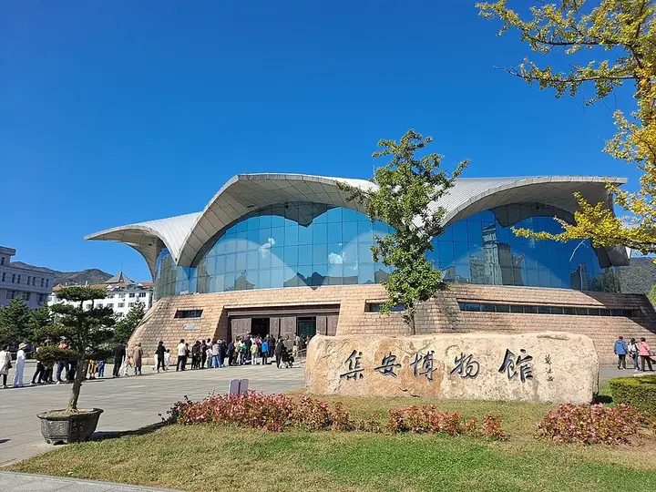
Photo adjustments
Full frame retained; resized proportionally to a maximum dimension of 960 pixels and converted to WebP quality 88. No crop, retouch, generated elements, or subject alteration. Final website rendition: full frame retained, proportionally resized to at most 720 pixels and converted to WebP. No additional retouching or subject alteration. Card displays may crop the view.
- Administrative area
- County-level city · 县级市
- Part of
- Tonghua
- Chinese name
- 集安市
- Local areas
- County-level city guide
Area & population
- Population · 2017
- 214,000
Source: cited geographic source, as of the dates shown.
Setting and landscape
The city lies on the southern slopes of the Changbai range, and woodland covers roughly two thirds of its area. The Laoling Mountains (老岭山脉) across the city shut out cold northern winds while moist Yellow Sea air travels up the Yalu valley; the city government ranks Ji'an first in Jilin for rainfall, accumulated temperature, frost-free days and low wind. The border with North Korea runs 203.5 kilometres along the river.
History
Under Emperor Wu of Han the area belonged to the Xuantu Commandery (玄菟郡). Goguryeo moved its capital here to Guonei City (国内城) in AD 3 and left for Pyongyang in 427; the city government counts 425 years and 19 kings. Closed to settlement under the Qing, the area became Ji'an County (辑安县) in 1902, renamed with new characters (集安县) in 1965. It became a county-level city in 1988 and a national historical and cultural city in 1994. On 1 July 2004 the Capital Cities and Tombs of the Ancient Koguryo Kingdom were inscribed on the World Heritage List.
What to see
The modern town is built on Guonei City, whose west and north walls and four corners survive. Wandu Mountain City (丸都山城), the wartime capital, stands on a hill north of the town. The Donggou Tombs (洞沟古墓群) cover 34.2 square kilometres; a 1966 survey counted 11,300 tombs, divided into seven zones, including the General's Tomb (将军坟), the Taiwang Tomb (太王陵) and more than 30 tombs with painted murals such as the Tomb of the Dancers (舞俑墓). The Gwanggaeto Stele (好太王碑), called the "first stele east of the sea" (海东第一碑), stands within its own scenic area in town.
The Yalu River National Gate scenic area (鸭绿江国门景区) includes the border railway bridge and a corridor marking the Chinese crossing into Korea in the Korean War. Wunü Peak National Forest Park (五女峰国家森林公园) has waterfalls and plank walkways through autumn-red forest.
Food and local products
The city government calls Ji'an the home of Chinese ginseng, with 1,700 years of use and about 500 of cultivation, and the only producing area of 'biantiao' ginseng (边条参). Ji'an biantiao ginseng, Ji'an ice wine (集安冰葡萄酒), chestnuts (集安板栗) and Yalu River salted duck eggs (集安鸭绿江咸鸭蛋) are national geographical-indication products.
Getting oriented
Ji'an is Tonghua's only border city and one of China's three rail crossings to North Korea. The Jilin section of the G331 border highway begins here, and the Shenyang–Baishan high-speed railway (沈白高铁) serves the city.
Highlights
- Guonei City 国内城: Goguryeo capital from AD 3; west and north walls and four corners survive under the modern town.
- Wandu Mountain City 丸都山城: Goguryeo wartime capital on a hill north of the town.
- Donggou Tombs 洞沟古墓群: 11,300 tombs counted in 1966 across seven zones, with over 30 mural tombs.
- Gwanggaeto Stele 好太王碑: Goguryeo stele known as the "first stele east of the sea".
- Yalu River National Gate scenic area 鸭绿江国门景区: Border scenic area with the railway bridge to North Korea.
- Wunü Peak National Forest Park 五女峰国家森林公园: Forest park with waterfalls and plank walkways.
Sources for this guide
集安市 - 维基百科,自由的百科全书 · Chinese Wikipedia · CC BY-SA 4.0
集安简介 · Ji'an Municipal People's Government (Ji'an Culture, Radio, Television and Tourism Bureau)
图说吉林:洞沟古墓群 · Jilin Provincial Local Chronicles Compilation Committee
“双节”首日集安文旅市场火爆 主要景区客流创新高 · People's Daily Online (Jilin channel)
Original English written from the listed sources and checked sentence by sentence against quoted extracts by a separate reviewer. Updated 2026-09-25.
Explore Ji'an
Core places to explore, with English and Chinese names.
Places to explore around Ji'an
 Koguryo Heritage Sites in Ji’an · 高句丽文物古迹景区
Koguryo Heritage Sites in Ji’an高句丽文物古迹景区
Ji’an’s Koguryo heritage brings together remains of capital cities and royal and noble tombs.
Read the place guide → Wunvfeng National Forest Park · 五女峰国家森林公园
Wunvfeng National Forest Park五女峰国家森林公园
Wunvfeng is a forested mountain park outside Ji'an, named for five distinctive peaks rather than the separate Wunü Mountain archaeological site in Liaoning. Its attractions combine rock ridges, wooded ravines and traces of…
Read the place guide → Yalu River National Gate Scenic Area (鸭绿江国门景区), Ji'an. Photograph: "Ji’an Kou’an".
Yalu River National Gate Scenic Area鸭绿江国门景区
Ji'an's Yalu River National Gate scenic area brings together road and railway border landmarks facing Manpo across the river.
Read the place guide →Plan your visit
Getting there
Ji'an is about 70 km in a straight line from central Tonghua. Search for 集安市 in a map app to find stations and your accommodation.
Where to stay →Build your route
Koguryo Heritage Sites in Ji’an and Wunvfeng National Forest Park are both listed here. The linked place guides have entrance and visit details.
Continue with Tonghua →More in Tonghua
Sources & geographic information
Administrative names and parent areas: Official geographic directory · Reference date 2026-09-06.
Some facts checked against 集安市 — Wikipedia contributors, CC BY-SA 4.0.
Photo: Koguryo Heritage Sites in Ji’an · Source photographer · License not provided. EXIF orientation normalized; resized without changing aspect ratio; converted to WebP. No subject edits.
Photo: Wunvfeng National Forest Park · Source photographer · License not provided. EXIF orientation normalized; resized without changing aspect ratio; converted to WebP. No subject edits.
Photo: Yalu River National Gate Scenic Area · Yumeto · CC BY-SA 4.0. Full frame retained; EXIF orientation normalized, proportionally resized to at most 800 pixels and converted to WebP. No generated pixels or subject changes. Cards may crop the display.

Map data © OpenStreetMap contributors. Pins mark approximate centres, not entrances or boundaries.