


Get to know Xifeng County
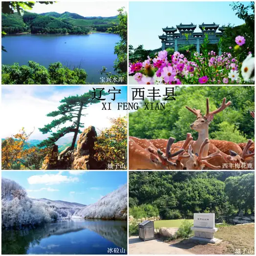
Photo adjustments
EXIF orientation normalized; resized without changing aspect ratio; converted to WebP. No subject edits.
- Administrative area
- County · 县
- Part of
- Tieling
- Chinese name
- 西丰县
- Local areas
- County guide
Area & population
- Area in the source
- 2,699.00 km²
- Population · 2020 census
- 225,123
- Administrative seat
- Xifeng Town (西丰镇)
Source: cited geographic source, as of the dates shown.
Setting and landscape
The land is high in the east and low in the west, and the county describes itself as seven parts hills to half a part water and two parts fields. More than 180 rivers and streams cross it. The largest, the Kou River (寇河), and the Nianpan River (碾盘河) in the south belong to the upper Liao River (辽河) system, while the Zhuzui River (猪咀河) in the north joins the East Liao. Winters are severe: snow lies for about 130 days, and the recorded low is −43.4 °C.
History
The Xichagou tombs (西岔沟古墓群) show that the area was an important centre of the northern Xiongnu in the early Western Han; weapons, horse gear and clothing from the site are displayed in the national history museum in Beijing. After Nurhaci (努尔哈赤) destroyed the Yehe (叶赫) in 1619, the area was closed off as part of the Qing imperial hunting grounds. It was reopened in 1896, settlers were invited to farm from 1897, and the county was created in 1902.
What to see
Chengzishan (城子山), 27 km south-east of the county town, has a mountain fortress built in the early-to-middle Western Han, important for the history of the Goguryeo and Fuyu (夫余) peoples. It became a national heritage site in 2013 and a national 4A scenic area in 2022; its 760-metre main peak is the second highest in northern Liaoning. Binglashan National Forest Park (冰砬山国家森林公园), where Liaoning's Xifeng and Qingyuan meet Jilin's Dongfeng, rises to 870.2 metres, the highest peak in northern Liaoning. Longhushan (龙虎山), 3 km from the county town, is a ski area with three runs.
Food and local products
Sika deer have been bred here for 300 years, and the Qing court made Xifeng the site of its royal deer park. Xifeng deer antler velvet (西丰鹿茸) is a protected geographical-indication product, and the county holds a large market for deer products, ginseng, forest frogs and herbs. Xifeng is also a centre of tussah (oak) silkworm rearing. Manchu dishes appear on tables from homes to hotels, and a folk rhyme handed down since the late Qing lists dishes such as blood sausage (血肠), and pork stewed with sour cabbage and glass noodles.
Highlights
- Chengzishan fortress 城子山山城: Western Han mountain fortress, national heritage site since 2013, inside a national 4A scenic area.
- Binglashan National Forest Park 冰砬山国家森林公园: Forest park on the Liaoning–Jilin border; its 870.2-metre summit is the highest in northern Liaoning.
- Xichagou tombs 西岔沟古墓群: Western Han cemetery linked to the northern Xiongnu, with finds shown in Beijing.
- Xifeng deer antler velvet 西丰鹿茸: Protected geographical-indication product from the county's 300-year sika deer tradition.
Sources for this guide
西丰概况 · Xifeng County People's Government
历史沿革 · Xifeng County People's Government
西丰县旅游资源 · Xifeng County Culture, Tourism, Radio and Television Bureau
Original English written from the listed sources and checked sentence by sentence against quoted extracts by a separate reviewer. Updated 2026-09-25.
Explore Xifeng County
Core places to explore, with English and Chinese names.
Xifeng County 西丰县
Plan your visit
Getting there
Xifeng County is about 100 km in a straight line from central Tieling. Search for 西丰县 in a map app to find stations and your accommodation.
Where to stay →More in Tieling
Sources & geographic information
Administrative names and parent areas: Official geographic directory · Reference date 2026-09-06.
Map data © OpenStreetMap contributors. Pins mark approximate centres, not entrances or boundaries.