


Get to know Xunhua Salar Autonomous County
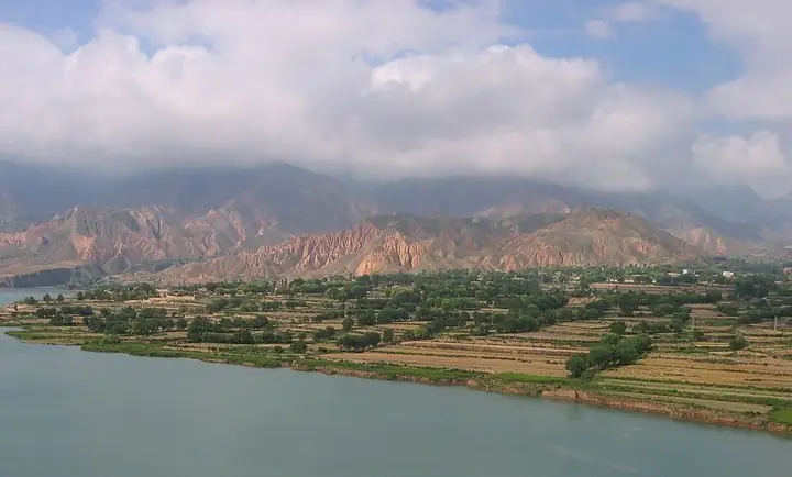
Photo adjustments
Full frame retained; resized proportionally to a maximum dimension of 960 pixels and converted to WebP quality 88. No crop, retouch, generated elements, or subject alteration. Final website rendition: full frame retained, proportionally resized to at most 720 pixels and converted to WebP. No additional retouching or subject alteration. Card displays may crop the view.
- Administrative area
- Autonomous county · 自治县
- Part of
- Haidong
- Chinese name
- 循化撒拉族自治县
- Local areas
- Autonomous county guide
Area & population
- Area in the source
- 2,100.00 km²
- Population · 2021
- 161,600
- Administrative seat
- Jishi
Source: cited geographic source, as of the dates shown.
Setting and landscape
The county sits at the eastern end of the Laji Mountains (拉鸡山), a branch of the Qilian range, and the Yellow River crosses its northern part from west to east for more than 90 km. Four large and medium hydropower stations have been built in the county: Gongboxia (公伯峡), Suzhi (苏只), Huangfeng (黄丰) and Jishixia (积石峡). The ground is high in the south and low in the north, ringed by mountains, and the county is one of the lower-lying parts of Qinghai. The county seat, Jishi (积石镇), takes its name from its position below Jishi Mountain (积石山) and stands at 1,840 metres. Its valley farms grow winter wheat, thin-shelled walnuts, long chillies and Sichuan pepper.
History
According to the county government, the Salar came from Turkmenistan in Central Asia along the Silk Road around the early 13th century and settled in Xunhua, more than 800 years ago. Salar tradition tells of two brothers, Galemang (尕勒莽) and Ahemang (阿合莽), who left Samarkand with a white camel carrying water, soil and a Quran; that Quran is still kept at Jiezi Mosque (街子清真大寺). The Qing set up Xunhua sub-prefecture (循化厅) in 1762. Its territory shrank under the Republic: Labrang (拉卜楞) was split off in 1926, and in 1930 parts of it went to the new counties of Minhe (民和) and Tongren (同仁).
What to see
The county government names Camel Spring (骆驼泉), a landmark of Salar history, the lake of Mengda Tianchi (孟达天池), a national AAAA scenic area, the former home of the Tenth Panchen Lama (十世班禅大师故居), and Hongguang village (红光村), built by soldiers of the Western Route Red Army. The Panchen Lama was born in Wendu (文都) on 19 February 1938. Wendu township also has the 800-year-old Wendu Monastery (文都大寺), a large Tibetan-style stupa of ten thousand Buddhas (万佛塔) and the old town of Wendu (文都古城), a provincial heritage site. In Qingshui township (清水乡), east of the county seat on the south bank of the Yellow River, Tashapo Mosque (塔沙坡清真寺) is a nationally protected site, and Dazhuang (大庄) keeps old wattle-walled houses (古篱笆楼).
Food and local products
Hand-pulled noodles are the county's signature trade. With little farmland per person, many local people left to open noodle shops, and the county government counts nearly ten thousand shops under the "Salar Family" (撒拉人家) brand across Chinese cities, with some in Pakistan, Malaysia and Singapore. The noodle trade in turn supports local walnut and pepper growing, which the county sums up as "one nut and two peppers" (一核两椒).
Highlights
- Mengda Tianchi 孟达天池: National AAAA scenic area in Qingshui township, named by the county government among its main sights.
- Camel Spring 骆驼泉: Scenic area the county government describes as a landmark of Salar history and culture.
- Jiezi Mosque 街子清真大寺: Keeps the Quran that Salar tradition says the founding brothers brought from Samarkand.
- Tenth Panchen Lama's former home 十世班禅大师故居: Birthplace in Wendu township, where he was born on 19 February 1938.
- Tashapo Mosque 塔沙坡清真寺: Nationally protected mosque in Qingshui township.
Sources for this guide
县情介绍 · Xunhua Salar Autonomous County People's Government
历史概况 · Xunhua Salar Autonomous County People's Government
循化撒拉族自治县 - 维基百科,自由的百科全书 · Wikipedia · CC BY-SA 4.0
积石镇 · Xunhua Salar Autonomous County People's Government
清水乡 · Xunhua Salar Autonomous County People's Government
文都乡 · Xunhua Salar Autonomous County People's Government
撒拉族 - 维基百科,自由的百科全书 · Wikipedia · CC BY-SA 4.0
Original English written from the listed sources and checked sentence by sentence against quoted extracts by a separate reviewer. Updated 2026-09-26.
Explore Xunhua Salar Autonomous County
Core places to explore, with English and Chinese names.
Places to explore around Xunhua Salar Autonomous County
 Mengda Heavenly Lake · 孟达天池
Mengda Heavenly Lake孟达天池
Mengda Tianchi (孟达天池) is a barrier lake of about 20 hectares lying in the heart of the Mengda National Nature Reserve, in Xunhua Salar Autonomous County, Haidong, Qinghai. The reserve was established in 1980 and approved as a national nature reserve in April 2000, and its protection target is a forest ecosystem.
Read the place guide →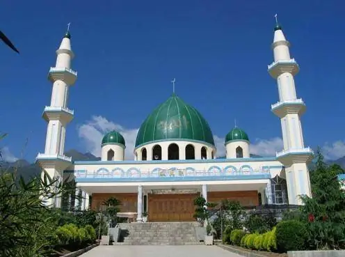 Jiezi Great Mosque and Salar Folk Culture · 街子清真大寺与撒拉族民俗
Jiezi Great Mosque and Salar Folk Culture街子清真大寺与撒拉族民俗
Jiezi Great Mosque (街子清真大寺) is the ancestral mosque of the Salar people, in Sanlanbahai village, Jiezi town, Xunhua Salar Autonomous County, Haidong, Qinghai. The catalogue pairs it with Salar folk custom, and the pages cited here carry that half as well: the story of the Salar migration, the spring and the ancestors' tombs within a hundred paces of the mosque, and the customs kept at them.
Read the place guide →Plan your visit
Getting there
Xunhua Salar Autonomous County is about 70 km in a straight line from central Haidong. Search for 循化撒拉族自治县 in a map app to find stations and your accommodation.
Where to stay →Build your route
Mengda Heavenly Lake and Jiezi Great Mosque and Salar Folk Culture are both listed here. The linked place guides have entrance and visit details.
Continue with Haidong →More in Haidong
Sources & geographic information
Administrative names and parent areas: Official geographic directory · Reference date 2026-09-06.
Some facts checked against 循化撒拉族自治县 — Wikipedia contributors, CC BY-SA 4.0.
Some facts checked against 撒拉族 — Wikipedia contributors, CC BY-SA 4.0.
Photo: Mengda Heavenly Lake · Source photographer · License not provided. EXIF orientation normalized; resized without changing aspect ratio; converted to WebP. No subject edits.
Photo: Jiezi Great Mosque and Salar Folk Culture · Source photographer · License not provided. EXIF orientation normalized; resized without changing aspect ratio; converted to WebP. No subject edits.
Map data © OpenStreetMap contributors. Pins mark approximate centres, not entrances or boundaries.