


Get to know Xinghai County
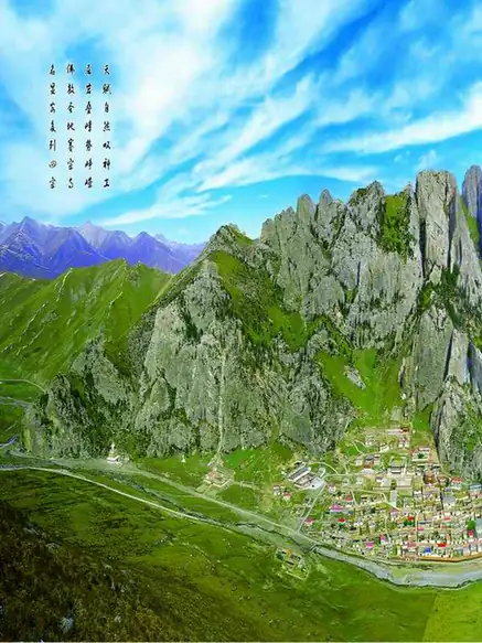
Photo adjustments
EXIF orientation normalized; resized without changing aspect ratio; converted to WebP. No subject edits.
- Administrative area
- County · 县
- Part of
- Hainan Tibetan Autonomous Prefecture
- Chinese name
- 兴海县
- Local areas
- County guide
Area & population
- Area in the source
- 13,158.00 km²
- Population · 2020
- 75,833
- Administrative seat
- Zigortang
Source: cited geographic source, as of the dates shown.
Setting and landscape
This is high country: the average altitude is 3,924 metres, and the county seat, Ziketan (子科滩镇), stands at 3,303 metres. The top is Suigen'ergang (虽根尔岗) in the Ela Mountains (鄂拉山) at 5,305 metres; the lowest point, 2,590 metres, is where the Yellow River leaves the county at Wuhetuo (吾合托) in Heka (河卡镇). The Yellow River runs 146.2 km through Xinghai, and three cascade hydropower stations on it, at Banduo (班多), Yangqu (羊曲) and Ciha (茨哈), are key national development projects. There are 19 hot spring points, with water at 40–58°C and up to 80°C. The frost-free season averages only 38 days.
History
In the Yongjia era (307–312) the Tuyuhun (吐谷浑), a Xianbei people who had moved west from Liaodong, set up their rule along the Daheba (大河坝) river. The Tang–Tibetan road later passed through: Princess Wencheng is said to have halted at Dafeichuan (大非川) near Daheba, and a Nalu (那录驿) post station stood on the Huangqing (黄清) river. In 1939 a Daheba office was carved out of Gonghe, and in 1945 it was raised to Xinghai County.
What to see
Saizong Mountain rises 30 km south-west of the county seat. Local tradition counts it among the three sacred Buddhist mountains of Amdo, and its name means "monkey fortress"; the mountain is of white rock. Saizong Monastery (赛宗寺) at its foot was founded in 1923 by Arig Tsang III (阿饶仓三世) of Rongwo Monastery (隆务寺) in Tongren (同仁), and grew into the largest Gelug monastery of the Hainan area, centred on a hundred-pillar assembly hall. Pilgrims circle the mountain past the "eighteen sights of Saizong" (赛宗十八景), including Guru Rinpoche's holy-water cave. The county also promotes the Heka grassland (河卡草原) and the Womengou waterfall (沃门沟瀑布).
Food and local products
The county has some 30 Chinese and Tibetan medicinal herbs, including snow lotus and rhubarb, and is one of Qinghai's main caterpillar fungus areas, harvesting about 10,000 kg a year. Local crafts include stone carving, Tibetan paper and Tibetan embroidery.
Highlights
- Saizong Monastery 赛宗寺: Founded 1923; the largest Gelug monastery of the Hainan area.
- Saizong Mountain 赛宗山: White-rock pilgrimage mountain with eighteen sacred sights; national AAA scenic area.
- Heka grassland 河卡草原: Promoted by the county on its main ecological tourism route.
- Womengou waterfall 沃门沟瀑布: Waterfall paired with Heka grassland and Saizong on the county's ecotourism route.
Sources for this guide
兴海县_各县概况_圣洁海南_海南藏族自治州人民政府 · Hainan Tibetan Autonomous Prefecture People's Government
赛宗民俗文化旅游景区_特色旅游_兴海县人民政府 · Xinghai County People's Government (county investment and tourism bureau)
兴海县推动生态文化旅游事业高质量发展_特色旅游_兴海县人民政府 · Xinghai County People's Government
兴海县 - 维基百科,自由的百科全书 · Wikipedia (Chinese) · CC BY-SA 4.0
Original English written from the listed sources and checked sentence by sentence against quoted extracts by a separate reviewer. Updated 2026-09-26.
Explore Xinghai County
Core places to explore, with English and Chinese names.
Xinghai County 兴海县
Plan your visit
Getting there
Xinghai County is about 95 km in a straight line from central Hainan Tibetan Autonomous Prefecture. Search for 兴海县 in a map app to find stations and your accommodation.
Where to stay →More in Hainan Tibetan Autonomous Prefecture
Sources & geographic information
Administrative names and parent areas: Official geographic directory · Reference date 2026-09-06.
Some facts checked against 兴海县 — Wikipedia contributors, CC BY-SA 4.0.
Map data © OpenStreetMap contributors. Pins mark approximate centres, not entrances or boundaries.