


Get to know Delingha
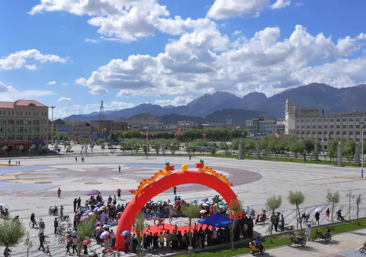
Photo adjustments
Full frame retained; proportionally resized and converted to WebP. No retouching or changes to the photographed subject. Card displays may crop the view.
- Administrative area
- County-level city · 县级市
- Part of
- Haixi Mongol and Tibetan Autonomous Prefecture
- Chinese name
- 德令哈市
- Local areas
- County-level city guide
Area & population
- Area in the source
- 27,700.00 km²
- Population · 2020
- 88,227
- Administrative seat
- Hexi Subdistrict
Source: cited geographic source, as of the dates shown.
Setting and landscape
The city's territory mixes mountains, lake basins, oases, gobi and desert, and the city government calls it one of the largest irrigated oasis farming areas in the Qaidam Basin. The town centre stands at 2,980 metres. The Bayin River rises in the Harke Mountains (哈尔科山) and flows west into Keluke Lake (可鲁克湖). In the north, in the heart of the Qilian range, lies Hala Lake (哈拉湖), fed mainly by glacial meltwater. It covers 607 square kilometres at 4,077 metres, and the city's tourism bureau lists it as Qinghai's second-largest lake after Qinghai Lake. Tuanjie Peak (团结峰), the main peak of the Qilian range at 5,826 metres, rises on its northern side.
History
The city government describes the area as a former stop on the southern Silk Road and an old Qiang territory. Mongols entered the Qaidam in 1512 and 1636, and today's local Mongols descend from Gushi Khan (固始汗) of the Khoshut. A Delingha county existed from 1958 to 1962 before merging into Ulan (乌兰县); the present city was split from Ulan on 19 April 1988. Mongol "Dedu" culture (德都蒙古文化) and the culture of state farms and settler migration both shape the city.
What to see
Keluke Lake (可鲁克湖) and Tuosu Lake (托素湖), about 42 km south-west of the city, form a national AAA scenic area. A 7 km channel links them: Keluke, the northern one, is fresh with reed beds, while Tuosu to the south has only an inlet and has turned salty through evaporation. The tourism bureau ranks an island in Tuosu as Qinghai's second bird-watching spot after Bird Island (鸟岛) on Qinghai Lake, and the lake's north-east corner is the so-called "alien relics" site with metal pipe-like objects. Locals call the pair the lovers' lakes. The Huaitoutala rock paintings (怀头他拉岩画), about 40 km north-west of Huaitoutala in the Haqiqiebuqie gully (哈其切布切沟), are provisionally dated to the late Northern dynasties and the Sui and Tang, and show animals, hunting, herding and dance. Baishu Mountain (柏树山) is known for its old cypresses. The poet Haizi (海子) wrote the poem "Sister, tonight I am in Delingha", and the city has a Haizi poetry exhibition hall (海子诗歌陈列馆).
Food and local products
In 1973 the prefecture stocked Keluke Lake with carp and crucian carp, the start of freshwater fish farming in the Qaidam; shrimp and crabs followed after 1986, and visitors eat highland freshwater fish there. Delingha is also a breeding base for Qaidam cashmere goats.
Highlights
- Keluke and Tuosu lakes 可鲁克湖、托素湖: Linked freshwater and saltwater lakes, a national AAA scenic area.
- Hala Lake 哈拉湖: Glacier-fed lake at 4,077 metres, Qinghai's second largest.
- Huaitoutala rock paintings 怀头他拉岩画: Rock art provisionally dated to the late Northern dynasties, Sui and Tang.
- Haizi poetry exhibition hall 海子诗歌陈列馆: Named for the poet who wrote "Sister, tonight I am in Delingha".
Sources for this guide
德令哈市 - 维基百科,自由的百科全书 · Wikipedia (Chinese) · CC BY-SA 4.0
德令哈市情简介-德令哈市人民政府 · Delingha Municipal People's Government
怀头他拉岩画-德令哈市人民政府 · Delingha Municipal People's Government
哈拉湖-德令哈市人民政府 · Delingha Municipal Bureau of Culture, Sports, Tourism, Radio and Television
可鲁克湖、托素湖国家AAA级高原生态旅游景区-德令哈市人民政府 · Delingha Municipal Bureau of Culture, Sports, Tourism, Radio and Television
Original English written from the listed sources and checked sentence by sentence against quoted extracts by a separate reviewer. Updated 2026-09-26.
Explore Delingha
Core places to explore, with English and Chinese names.
Places to explore around Delingha
 AI illustration · AI
 Plan your visit
Getting there
Delingha covers the centre of Haixi Mongol and Tibetan Autonomous Prefecture. Search for 德令哈市 in a map app to find stations and your accommodation.
Where to stay →Build your route
Start with Keluke Lake. The linked place guides have entrance and visit details.
Continue with Haixi Mongol and Tibetan Autonomous Prefecture →More in Haixi Mongol and Tibetan Autonomous Prefecture
Sources & geographic information
Administrative names and parent areas: Official geographic directory · Reference date 2026-09-06.
Some facts checked against 德令哈市 — Wikipedia contributors, CC BY-SA 4.0.
Map data © OpenStreetMap contributors. Pins mark approximate centres, not entrances or boundaries.