


Get to know Golmud
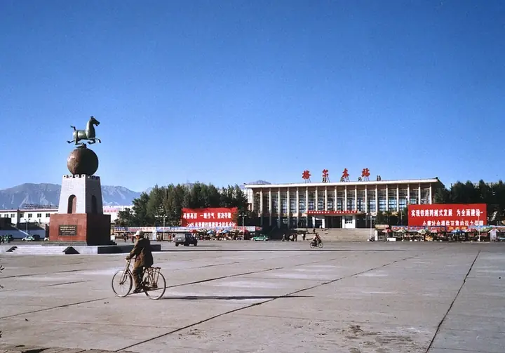
Photo adjustments
Full frame retained; resized proportionally to a maximum dimension of 960 pixels and converted to WebP quality 88. No crop, retouch, generated elements, or subject alteration. Final website rendition: full frame retained, proportionally resized to at most 720 pixels and converted to WebP. No additional retouching or subject alteration. Card displays may crop the view.
- Administrative area
- County-level city · 县级市
- Part of
- Haixi Mongol and Tibetan Autonomous Prefecture
- Chinese name
- 格尔木市
- Local areas
- County-level city guide
Area & population
- Area in the source
- 119,165.00 km²
- Population · 2020
- 221,863
- Administrative seat
- Kunlun Road Subdistrict
Source: cited geographic source, as of the dates shown.
Setting and landscape
The city borders the Hoh Xil (可可西里) national nature reserve to the south and the Qarhan Salt Lake (察尔汗盐湖) to the north, and its Tanggula Mountains (唐古拉山) area is part of the Sanjiangyuan (三江源) nature reserve. The city counts the source of the Yangtze among its natural sights. Wetlands such as the Yushui River (渔水河), Wuzi Lake (五子湖) and Jinyu Lake (金鱼湖) ring the town. The prefecture government lists sunshine of more than 3,500 hours a year.
History
Golmud was set up as an administration in 1954 and rose as an industrial town based on potash, salt-lake chemicals, oil and gas. General's Building Park (将军楼公园), a 4A scenic area, is built around the former residence of General Mu Shengzhong (慕生忠) and the office of the road-building troops, and commemorates the building of the Qinghai–Tibet Highway and Railway. Its Tianlu memorial tower (天路纪念塔) is 39.16 m high, a figure matched to the combined length of the two routes, and the park also holds a geological museum and a memorial hall to the general.
What to see
The Qarhan Salt Lake lies at 2,670 m and covers 5,856 square km, fed by the Golmud (格尔木河) and Qaidam (柴达木河) rivers; its scenic area is graded 4A. The Qinghai–Tibet Railway and Highway run straight across a natural salt crust 15 to 18 m thick with brine beneath, a stretch known as the "Ten-Thousand-Zhang Salt Bridge" (万丈盐桥). The lake is also a national mine geopark and an important base of China's potash production, and its salt flowers crystallise in many shapes.
Kunlun Pass (昆仑山口), at 4,767 m, carries the Qinghai–Tibet Highway and Railway and is a viewpoint over the Kunlun Mountains. Yuzhu Peak (玉珠峰), 6,178 m high and 140 km from the city, is 40 km from National Highway 109 and draws climbers. The city's profile also names the Yaochi Pool of the Queen Mother of the West (西王母瑶池) and a Euphrates poplar forest (胡杨林) among its scenic spots.
Getting oriented
Three trunk highways meet at Golmud, the Qinghai–Tibet, Qinghai–Xinjiang and Golmud–Dunhuang roads, and the Qinghai–Tibet, Golmud–Korla and Golmud–Dunhuang railways pass through the city. The prefecture government describes it as a hub linking Gansu, Xinjiang, Qinghai and Tibet.
Highlights
- Qarhan Salt Lake 察尔汗盐湖: A salt lake at 2,670 m, with a 4A scenic area, whose salt crust, 15 to 18 m thick, carries the Qinghai–Tibet Railway and Highway.
- Kunlun Pass 昆仑山口: A 4,767 m pass on the Qinghai–Tibet Highway and Railway with views of the Kunlun Mountains.
- General's Building Park 将军楼公园: A 4A park built around General Mu Shengzhong's residence, commemorating the Qinghai–Tibet road and railway.
- Yuzhu Peak 玉珠峰: A 6,178 m mountain 40 km from National Highway 109, visited by climbers.
Sources for this guide
格尔木市-海西州人民政府 · Haixi Mongol and Tibetan Autonomous Prefecture People's Government
格尔木察尔汗盐湖景区AAAA-海西州人民政府 · Haixi Mongol and Tibetan Autonomous Prefecture People's Government
昆仑山口-海西州人民政府 · Haixi Mongol and Tibetan Autonomous Prefecture People's Government
格尔木将军楼公园AAAA-海西州人民政府 · Haixi Mongol and Tibetan Autonomous Prefecture People's Government
玉珠峰-海西州人民政府 · Haixi Mongol and Tibetan Autonomous Prefecture People's Government
Original English written from the listed sources and checked sentence by sentence against quoted extracts by a separate reviewer. Updated 2026-09-26.
Explore Golmud
Core places to explore, with English and Chinese names.
Places to explore around Golmud
 AI illustration · AI 示意图(仅供参考,非该地点实拍)
Qarhan Salt Lake Visitor Area察尔汗盐湖正规开放游览区
Chaerhan Salt Lake (察尔汗盐湖) is a 5,856 sq km salt lake in the south-central Qaidam basin in Golmud city, Haixi Mongolian and Tibetan Autonomous Prefecture, Qinghai, whose scenic area was named a national AAAA-grade tourist scenic area in August 2023.
Read the place guide →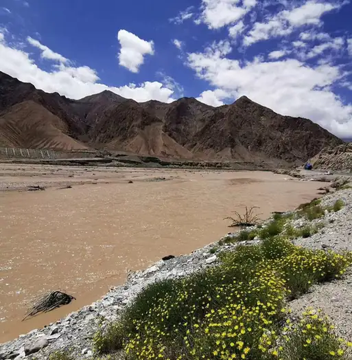 Kunlun Pass Roadside Viewpoint · 昆仑山口正规公路观景点
Kunlun Pass Roadside Viewpoint昆仑山口正规公路观景点
Kunlun Pass (昆仑山口) is the pass on the Qinghai-Tibet highway and railway south of Golmud in Haixi Mongolian and Tibetan Autonomous Prefecture, Qinghai, at an altitude the two cited accounts give as 4,767 m and 4,768 m.
Read the place guide →Plan your visit
Getting there
Golmud is about 245 km in a straight line from central Haixi Mongol and Tibetan Autonomous Prefecture. Search for 格尔木市 in a map app to find stations and your accommodation.
Where to stay →Build your route
Qarhan Salt Lake Visitor Area and Kunlun Pass Roadside Viewpoint are both listed here. The linked place guides have entrance and visit details.
Continue with Haixi Mongol and Tibetan Autonomous Prefecture →More in Haixi Mongol and Tibetan Autonomous Prefecture
Sources & geographic information
Administrative names and parent areas: Official geographic directory · Reference date 2026-09-06.
Photo: Kunlun Pass Roadside Viewpoint · Source photographer · License not provided. EXIF orientation normalized; resized without changing aspect ratio; converted to WebP. No subject edits.
Map data © OpenStreetMap contributors. Pins mark approximate centres, not entrances or boundaries.