


Get to know Tianjun County
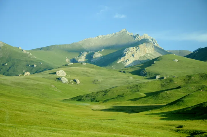
Photo adjustments
Full frame retained; proportionally resized and converted to WebP. No retouching or changes to the photographed subject. Card displays may crop the view.
- Administrative area
- County · 县
- Part of
- Haixi Mongol and Tibetan Autonomous Prefecture
- Chinese name
- 天峻县
- Local areas
- County guide
Area & population
- Area in the source
- 25,989.00 km²
- Population · 2020
- 23,203
- Administrative seat
- Xinyuan
Source: cited geographic source, as of the dates shown.
Setting and landscape
The county sits mostly above 4,000 m, with a low point of 2,850 m and a high point of 5,826.8 m. It has no frost-free season and an average of 97 days of strong wind a year; crops do not ripen, and herding is the base of the economy. Natural grassland and land suited to sown pasture make up about 61 per cent of its area. Tianjun borders Qilian (祁连县) and Gangca (刚察县) counties to the east, Delingha (德令哈市) to the west and Subei (肃北蒙古族自治县) in Gansu to the northwest.
Hala Lake (哈拉湖), a saltwater lake shared with Delingha at the foot of the Shule Nanshan (疏勒南山), is fed by glacier meltwater and covers 607 square km. Chinese Wikipedia lists it as the largest lake in the Qaidam Basin, with a large population of naked carp (湟鱼) and breeding geese, sandpipers and gulls.
History
In AD 4 the area came under the Xihai commandery (西海郡) set up under Wang Mang (王莽); it later passed to the Tuyuhun (吐谷浑) and, in 663, to the Tibetan empire. From 1725, under the Qing, two Khoshut (和硕特) Mongol banners grazed the land, and in the early Xianfeng reign the Tibetan Wangshidaihai (汪什代海) tribe moved in. The Tianjun Tibetan Autonomous Area was formed on 25 July 1954 and became Tianjun County on 1 July 1955.
What to see
The Shenhu Zhiyuan scenic area (神湖之源风景区), graded 3A in December 2010, groups ten sites including Mount Tianjun (天峻山), a stone forest and Hala Lake. Hundreds of karst stone pillars stand on the southern slope of the main peak of Mount Tianjun, and Xiulong Gully (秀龙沟) has waterfalls, springs and dense shrubs.
Among local foods, the prefecture government names Tianjun milk skin (天峻奶皮), a hand-made dairy product with a history of nearly a century.
Getting oriented
The Qinghai–Tibet Railway crosses the south of the county for 95 km, with stations at Jianghe (江河站) and Tianjun. Tianjun station is 307 km by rail from Xining (西宁) and 229 km from the prefecture seat at Delingha.
Highlights
- Hala Lake 哈拉湖: A 607 square km glacier-fed saltwater lake shared with Delingha, with naked carp and nesting waterbirds.
- Shenhu Zhiyuan scenic area 神湖之源风景区: A 3A scenic area since 2010 with the karst stone forest of Mount Tianjun and Xiulong Gully.
- Tianjun milk skin 天峻奶皮: A hand-made dairy product with a history of nearly a century.
Sources for this guide
天峻县 - 维基百科,自由的百科全书 · Wikipedia (Chinese) · CC BY-SA 4.0
天峻神湖之源风景区 AAA-海西州人民政府 · Haixi Mongol and Tibetan Autonomous Prefecture People's Government
天峻奶皮-海西州人民政府 · Haixi Mongol and Tibetan Autonomous Prefecture People's Government
哈拉湖 (青海) - 维基百科,自由的百科全书 · Wikipedia (Chinese) · CC BY-SA 4.0
Original English written from the listed sources and checked sentence by sentence against quoted extracts by a separate reviewer. Updated 2026-09-26.
Explore Tianjun County
Core places to explore, with English and Chinese names.
Tianjun County 天峻县
Plan your visit
Getting there
Tianjun County is about 130 km in a straight line from central Haixi Mongol and Tibetan Autonomous Prefecture. Search for 天峻县 in a map app to find stations and your accommodation.
Where to stay →More in Haixi Mongol and Tibetan Autonomous Prefecture
Sources & geographic information
Administrative names and parent areas: Official geographic directory · Reference date 2026-09-06.
Some facts checked against 天峻县 — Wikipedia contributors, CC BY-SA 4.0.
Some facts checked against 哈拉湖 (青海) — Wikipedia contributors, CC BY-SA 4.0.
Map data © OpenStreetMap contributors. Pins mark approximate centres, not entrances or boundaries.