


Get to know Ulan County

Photo adjustments
Full frame retained; EXIF orientation normalized, proportionally resized to at most 800 pixels and converted to WebP. No generated pixels or subject changes. Cards may crop the display.
- Administrative area
- County · 县
- Part of
- Haixi Mongol and Tibetan Autonomous Prefecture
- Chinese name
- 乌兰县
- Local areas
- County guide
Area & population
- Area in the source
- 12,858.16 km²
- Population · 2020
- 31,507
- Administrative seat
- Xireg
Source: cited geographic source, as of the dates shown.
Setting and landscape
The county seat, Xireg (希里沟镇), stands at 2,960 m in a dry continental climate with a mean annual temperature of 3.2°C. The county has two salt lakes, Chaka and Keke (柯柯), and its mineral deposits include lake salt, mirabilite, feldspar and quartz. Sunshine runs to 2,800 to 3,100 hours a year.
History
The land was grazing ground of the Khoshut (和硕特) Mongols and belonged to Dulan County (都兰县) in the Republican era. Ulan County was created in January 1959; Delingha County was merged into it in June 1962, and in April 1988 its western district and five townships were split off to form the city of Delingha (德令哈市).
What to see
Chaka takes its name from the Tibetan word for "salt". The lake covers more than 100 square km, with crystalline salt under a salt crust, and has been worked for more than 3,000 years; the prefecture government calls it the salt lake with the longest history in the Qaidam Basin. Its scenic area is graded 4A. Visitors can watch large salt-dredging boats at work and see salt flowers and piled salt, while a small train runs along the shore.
Halihatu National Forest Park (哈里哈图国家森林公园), approved at national level in 2006, holds one of the best-preserved natural forests in Haixi, with 62 natural and four cultural sites. The county also contains the Jinzihai national desert park (金子海国家沙漠公园) and Dulan Monastery (都兰寺), a Tibetan Buddhist temple.
Food and local products
Chaka sheep (茶卡羊) graze on natural pasture by the salt lake and carry a national geographical-indication listing for agricultural products. Their meat is served as hand-held boiled mutton, whole roast lamb and kang-pot lamb ribs (炕锅羊排). The county also raises quinoa and Bactrian camels.
Getting oriented
The Qinghai–Tibet Highway, the Qinghai–Xinjiang Highway and the Qinghai–Tibet Railway run through the county. The county town is 374 km west of Xining (西宁) and 115 km east of the prefecture seat at Delingha.
Highlights
- Chaka Salt Lake 茶卡盐湖: A salt lake worked for more than 3,000 years, with a 4A scenic area.
- Halihatu National Forest Park 哈里哈图国家森林公园: A national forest park since 2006 protecting one of Haixi's best-preserved natural forests.
- Chaka sheep 茶卡羊: Lakeside-grazed sheep with a national geographical-indication listing.
Sources for this guide
乌兰县-海西州人民政府 · Haixi Mongol and Tibetan Autonomous Prefecture People's Government
乌兰茶卡盐湖景区 AAAA-海西州人民政府 · Haixi Mongol and Tibetan Autonomous Prefecture People's Government
乌兰县哈里哈图国家森林公园 AA-海西州人民政府 · Haixi Mongol and Tibetan Autonomous Prefecture People's Government
茶卡羊肉-海西州人民政府 · Haixi Mongol and Tibetan Autonomous Prefecture People's Government
乌兰县 - 维基百科,自由的百科全书 · Wikipedia (Chinese) · CC BY-SA 4.0
Original English written from the listed sources and checked sentence by sentence against quoted extracts by a separate reviewer. Updated 2026-09-26.
Explore Ulan County
Core places to explore, with English and Chinese names.
Places to explore around Ulan County
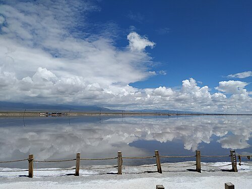 Chaka Salt Lake, Haixi ·
 Plan your visit
Getting there
Ulan County is about 100 km in a straight line from central Haixi Mongol and Tibetan Autonomous Prefecture. Search for 乌兰县 in a map app to find stations and your accommodation.
Where to stay →Build your route
Start with Chaka Salt Lake. The linked place guides have entrance and visit details.
Continue with Haixi Mongol and Tibetan Autonomous Prefecture →More in Haixi Mongol and Tibetan Autonomous Prefecture
Sources & geographic information
Administrative names and parent areas: Official geographic directory · Reference date 2026-09-06.
Some facts checked against 乌兰县 — Wikipedia contributors, CC BY-SA 4.0.
Photo: Chaka Salt Lake · 西安兵马俑 · CC BY-SA 4.0. Wikimedia thumbnail; fitted to the ranking-card frame.

Map data © OpenStreetMap contributors. Pins mark approximate centres, not entrances or boundaries.