


Get to know Chengzhong District
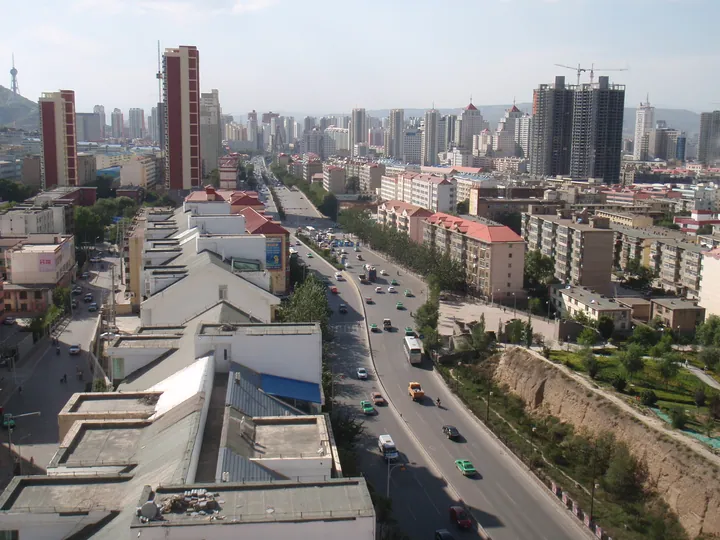
Photo adjustments
Full frame retained; proportionally resized and converted to WebP. No retouching or changes to the photographed subject. Card displays may crop the view.
- Administrative area
- District · 市辖区
- Part of
- Xining
- Chinese name
- 城中区
- Local areas
- District guide
Area & population
- Population · 2020
- 325,813
- Administrative seat
- Yinma Street Subdistrict
Source: cited geographic source, as of the dates shown.
Setting and landscape
The Huangshui River (湟水) separates the district from Chengbei District (城北区) to the north. On the west, the Nanchuan River (南川河) and the Xishan hills (西山) form the line with Chengxi District (城西区), while Wuyi Road (五一路), the Huayuan North and South Streets (花园南北街) and Jianxin Lane (建新巷) mark the eastern edge with Chengdong District (城东区). The ground rises towards the south-west and falls away to the north-east, at an average altitude of about 2,231 metres. The district contains seven urban subdistricts and one town, Zongzhai (总寨镇).
What to see
Several of Xining's historic sites lie in the district and are on Qinghai's provincial heritage list: the Confucian Temple (文庙), placed on the first list, Nanchan Temple (南禅寺) on the fourth, and the City God Temple (城隍庙) and the Nantan Old City (南滩古城) on the fifth. The Nantan Old City is a Ming-period site listed on 15 September 1988. Later lists added the Xiangshuiyuan section of the Xining city wall (西宁古城墙香水园段), the Great Buddha Temple (大佛寺), the old buildings of Hongjue Temple Street (宏觉寺街) and the Shanxi-Shaanxi Guild Hall (山陕会馆).
Nanchan Temple's "Clouds lingering over Phoenix Terrace" (凤台留云) is counted among the Eight Views of Xining, and crowds climb Phoenix Terrace (凤凰台) at the Double Ninth Festival. The Xining Martyrs' Cemetery (西宁烈士陵园) and the Memorial Hall of the Western Route Army of the Chinese Workers' and Peasants' Red Army (中国工农红军西路军纪念馆) are the province's main places for remembering revolutionary dead. Chinese Wikipedia also names the Central Square (中心广场) and Nanshan Park (南山公园) among the district's places to visit.
Highlights
- Nanchan Temple 南禅寺: Provincial heritage site (fourth list); its "Clouds lingering over Phoenix Terrace" scene is one of the Eight Views of Xining.
- Confucian Temple 文庙: On the first list of Qinghai provincial heritage sites.
- Nantan Old City 南滩古城: Ming-period site, provincial heritage listing of 15 September 1988.
- Western Route Army Memorial Hall 中国工农红军西路军纪念馆: One of Qinghai's main sites for commemorating revolutionary martyrs.
Sources for this guide
城中区概况-青海省西宁市城中区政府网 · Chengzhong District People's Government, Xining
城中区 (西宁市) - 维基百科,自由的百科全书 · Chinese Wikipedia · CC BY-SA 4.0
青海省文物保护单位 - 维基百科,自由的百科全书 · Chinese Wikipedia · CC BY-SA 4.0
南滩古城 - 维基百科,自由的百科全书 · Chinese Wikipedia · CC BY-SA 4.0
Original English written from the listed sources and checked sentence by sentence against quoted extracts by a separate reviewer. Updated 2026-09-26.
Explore Chengzhong District
Core places to explore, with English and Chinese names.
Chengzhong District 城中区
Plan your visit
Getting there
Chengzhong District covers the centre of Xining. Search for 城中区 in a map app to find stations and your accommodation.
Where to stay →More in Xining
Sources & geographic information
Administrative names and parent areas: Official geographic directory · Reference date 2026-09-06.
Some facts checked against 城中区 (西宁市) — Wikipedia contributors, CC BY-SA 4.0.
Some facts checked against 青海省文物保护单位 — Wikipedia contributors, CC BY-SA 4.0.
Some facts checked against 南滩古城 — Wikipedia contributors, CC BY-SA 4.0.
Map data © OpenStreetMap contributors. Pins mark approximate centres, not entrances or boundaries.