


Get to know Huangyuan County
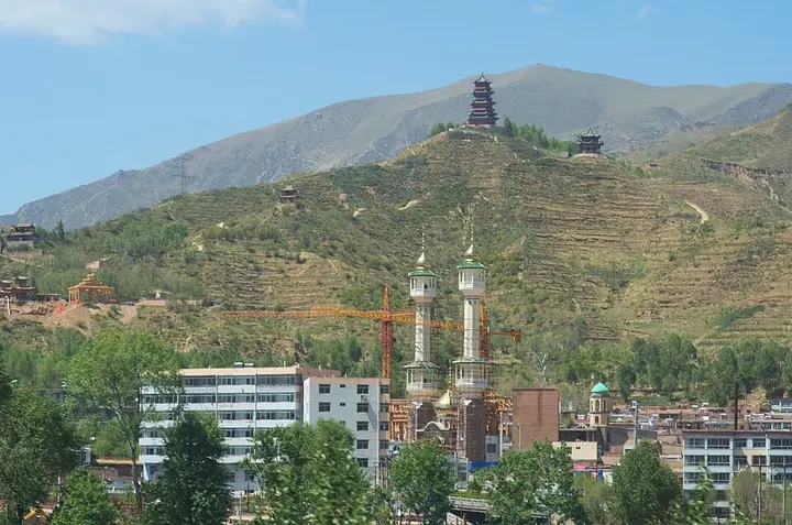
Photo adjustments
Full frame retained; proportionally resized and converted to WebP. No retouching or changes to the photographed subject. Card displays may crop the view.
- Administrative area
- County · 县
- Part of
- Xining
- Chinese name
- 湟源县
- Local areas
- County guide
Area & population
- Area in the source
- 1,545.00 km²
- Population · 2020
- 109,802
- Administrative seat
- Chengguan Town
Source: cited geographic source, as of the dates shown.
Setting and landscape
Apart from two narrow valleys along the Huangshui and the Yaoshui River (药水河), which join southeast of the county town, the county is mountainous, and elevations range from 2,470 to 4,898 metres. The county town stands at 2,690 metres. Four gorges lead to the town: Xishi (西石峡), Yaoshui (药水峡), Bayan (巴燕峡) and Lasha (拉沙峡). Summers are short and cool and winters long and dry.
History
The county town was known as Dan'gaer (丹噶尔), a market for the tea-horse trade and everyday goods. Under the Qing Jiaqing and Daoguang emperors merchants crowded in, and it was called the "little Beijing of the Qinghai-Tibet Plateau". A Dan'gaer sub-prefecture (丹噶尔厅) under Xining Prefecture was created in the Daoguang reign because of this trade, and in 1913 it became Huangyuan County, named for the source of the Huangshui.
What to see
Dan'gaer Ancient Town (丹噶尔古城) began as a garrison town in the Hongwu reign of the Ming. Its old streets run for 800 metres, mainly Dan'gaer Street and Fengsheng Street (丰盛街), past the City God Temple, the Dan'gaer sub-prefecture office, a Confucian temple, old shopfronts and the Huozu Pavilion (火祖阁). Shops along its streets display Huangyuan paper-cutting and embroidery. Huangyuan lanterns (湟源排灯) are listed as intangible cultural heritage of Huangyuan County.
Riyue Mountain (日月山), 40 kilometres southwest of the county town, was anciently called Chiling (赤岭), "red ridge", after the colour of its rock. The Qinghai-Tibet Highway crosses it at a 3,520-metre pass. Princess Wencheng (文成公主) passed this way on her journey to Tibet, and the scenic area has her statue, the Sun and Moon pavilions and a museum of the ancient Qinghai roads. It became a national 4A scenic area in December 2019. The mountain marks several natural boundaries: farmland lies to the east and open pasture to the west, with Qinghai Lake (青海湖) to the northwest.
Food and local products
Huangyuan grows wheat, highland barley, potatoes and broad beans; its "horse-tooth" broad beans (马牙蚕豆) are exported to Japan and Southeast Asia. Huangyuan mature vinegar (湟源陈醋) is a national geographical-indication product.
Highlights
- Dan'gaer Ancient Town 丹噶尔古城: Former Ming garrison and tea-horse trading town with 800 metres of old streets.
- Riyue Mountain 日月山: Pass on Princess Wencheng's route to Tibet, dividing farmland from pasture; 4A scenic area since 2019.
- Huangyuan lanterns 湟源排灯: Lanterns listed as intangible cultural heritage of Huangyuan County.
- Huangyuan mature vinegar 湟源陈醋: National geographical-indication product.
Sources for this guide
湟源概况_湟源概况_新闻_湟源县人民政府门户网 · Huangyuan County People's Government (county gazetteer office)
走进“青藏高原的小北京”_湟源风光_新闻_湟源县人民政府门户网 · Huangyuan County People's Government (reprinting Qinghai News)
细细感受日月山的美_文化旅游_新闻_湟源县人民政府门户网 · Huangyuan County People's Government (reprinting Qinghai Daily)
日月山景区荣升为AAAA级国家旅游景区_文化旅游_新闻_湟源县人民政府门户网 · Huangyuan County People's Government
湟源县 - 维基百科,自由的百科全书 · Chinese Wikipedia · CC BY-SA 4.0
Original English written from the listed sources and checked sentence by sentence against quoted extracts by a separate reviewer. Updated 2026-09-25.
Explore Huangyuan County
Core places to explore, with English and Chinese names.
Places to explore around Huangyuan County
 A gate at Danggar Ancient Town · 丹噶尔古城 Photograph date recorded by the source: 9 October 2015.
Danggar Ancient Town丹噶尔古城
Danggar in Huangyuan grew as a town on the routes between the farming valleys and the plateau. Its east and west gates, Yingchun and Gonghai, provide a clear way to understand the old street axis. Temples dedicated to the City…
Read the place guide → The Sun and Moon Mountain visitor approach in Qinghai, October 2015.
Sun and Moon Mountain日月山
Riyue Mountain marks a transition between the farming valleys around Xining and the pastoral landscapes towards Qinghai Lake. The pass is associated with the historical Tang–Tibet route and with legends of Princess Wencheng’s…
Read the place guide →Local life & food
Huangyuan County local specialties
湟源县特色美食 · 1 specialties to discover
 Qinghai sour-spicy pork soup 青海酸辣里脊AI dish illustration / AI 菜品示意图
Expect tender or lightly coated pork, crisp vegetable pieces and a sharp, warming broth. Peppery heat and vinegar sourness are distinct, so asking for less chilli may not change the soup's acidity.
Source ↗Read the dish guide →All dish names · 全部菜名 (1)
More dishes from across Qinghai are in the Qinghai food guide.
Plan your visit
Getting there
Huangyuan County is about 45 km in a straight line from central Xining. Search for 湟源县 in a map app to find stations and your accommodation.
Where to stay →Build your route
Danggar Ancient Town and Sun and Moon Mountain are about 30 km apart in a straight line. The linked place guides have entrance and visit details.
Continue with Xining →More in Xining
Sources & geographic information
Administrative names and parent areas: Official geographic directory · Reference date 2026-09-06.
Some facts checked against 湟源县 — Wikipedia contributors, CC BY-SA 4.0.
Photo: Danggar Ancient Town · 慕尼黑啤酒 · CC BY-SA 4.0. Full frame retained; proportionally resized and converted to WebP. No retouching or changes to the photographed subject. Card displays may crop the view.

Photo: Sun and Moon Mountain · 慕尼黑啤酒 · CC BY-SA 3.0. Proportionally resized and converted to WebP without cropping, retouching or changing the photographed subject.

Map data © OpenStreetMap contributors. Pins mark approximate centres, not entrances or boundaries.