


Get to know Jiaxiang County
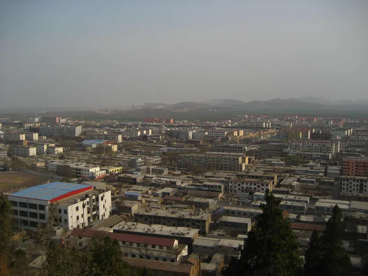
Photo adjustments
Full frame retained; proportionally resized and converted to WebP. No retouching or changes to the photographed subject. Card displays may crop the view.
- Administrative area
- County · 县
- Part of
- Jining
- Chinese name
- 嘉祥县
- Local areas
- County guide
Area & population
- Area in the source
- 838.56 km²
- Population · 2019
- 933,614
Source: cited geographic source, as of the dates shown.
Setting and landscape
The county is a long rectangle running northwest to southeast, 47.5 kilometres long and 16 wide, and the land slopes down in that direction, mostly between 35 and 40 metres above sea level. Its hills, mostly aligned northeast to southwest, rise like islands from the plain. The highest is Mengliang Mountain (孟良山), once called Tashan, at 243.1 metres, on the border of Zhifang (纸坊) and Maji (马集) towns. The county town sits in the middle of the county, 22 kilometres west of Jining.
History
Stone knives, axes and chisels dug up at Shuangfeng (双凤村) and Changzhiji (长直集村) villages show people living here in the Neolithic. The county itself was created in 1147, under the Jin, from parts of Juye (巨野) and Rencheng (任城) counties, with its seat at Shankou (山口镇). The name, 'fine and auspicious', recalls the story that Duke Ai of Lu (鲁哀公) caught a qilin while hunting in the west. Besides Zengzi, several of his disciples, among them Yuezheng Zichun (乐正子春) and Gongming Yi (公明仪), were Jiaxiang people.
What to see
The Wu Family Shrines stand at the north foot of Wuzhai Mountain (武翟山), formerly Ziyun Mountain, in Zhifang town: three stone offering halls and a pair of gate pillars from a late Eastern Han family cemetery, begun in 147. Their carvings were on the first national heritage list. The Wu Liang Shrine (武梁祠) of 151 is a single-bay stone hall 2.41 metres wide, its pictures cut in flat low relief with incised lines by a craftsman named Wei Gai (卫改) and laid out in registers of sages, rulers, filial sons, assassins and processions. A museum founded on the site in 2015 holds 422 items, including 46 Han pictorial stones from the original shrines.
The Zeng Temple (曾庙), or Zongsheng Temple (宗圣庙), honours Zeng Can (曾参) at the south foot of South Wushan (南武山), 23 kilometres south of the county town. It is a group of official-style buildings with a clear Ming character, faces south, measures 230 by 120 metres with more than thirty buildings, and was listed as a national heritage site in 2006. Qingshan Temple (青山寺), 8.2 kilometres south of the county town on the west side of Qing Hill (青山), is a group of old buildings centred on the Huijigong Temple (惠济公庙), first a shrine to the Lord of Jiao (焦王).
Highlights
- Wu Family Shrines 武氏祠: Late Eastern Han stone offering halls begun in 147, with carvings on the first national heritage list.
- Wu Liang Shrine 武梁祠: Stone hall of 151 whose relief pictures were carved by the craftsman Wei Gai.
- Zeng Temple 曾庙: Ming-style temple to Zeng Can below South Wushan, national heritage site since 2006.
- Qingshan Temple 青山寺: Old buildings around the Huijigong Temple, once the shrine of the Lord of Jiao.
Sources for this guide
嘉祥县 - 维基百科,自由的百科全书 · Wikipedia (Chinese) · CC BY-SA 4.0
武氏祠 - 维基百科,自由的百科全书 · Wikipedia (Chinese) · CC BY-SA 4.0
Wu Family Shrines - Wikipedia · Wikipedia (English) · CC BY-SA 4.0
Original English written from the listed sources and checked sentence by sentence against quoted extracts by a separate reviewer. Updated 2026-09-23.
Explore Jiaxiang County
Core places to explore, with English and Chinese names.
Jiaxiang County 嘉祥县
Plan your visit
Getting there
Jiaxiang County is about 20 km in a straight line from central Jining. Search for 嘉祥县 in a map app to find stations and your accommodation.
Where to stay →More in Jining
Sources & geographic information
Administrative names and parent areas: Official geographic directory · Reference date 2026-09-06.
Some facts checked against 嘉祥县 — Wikipedia contributors, CC BY-SA 4.0.
Some facts checked against 武氏祠 — Wikipedia contributors, CC BY-SA 4.0.
Some facts checked against Wu Family Shrines — Wikipedia contributors, CC BY-SA 4.0.
Map data © OpenStreetMap contributors. Pins mark approximate centres, not entrances or boundaries.