


Get to know Wenshang County
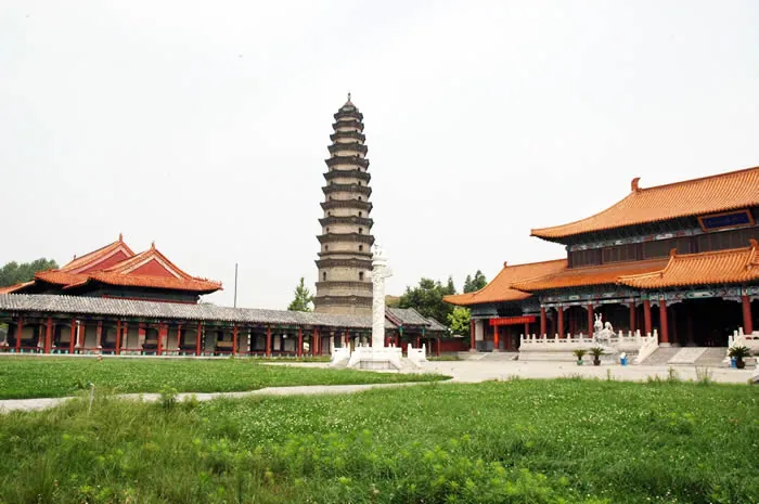
Photo adjustments
Full frame retained; proportionally resized and converted to WebP. No retouching or changes to the photographed subject. Card displays may crop the view.
- Administrative area
- County · 县
- Part of
- Jining
- Chinese name
- 汶上县
- Local areas
- County guide
Area & population
- Area in the source
- 877.00 km²
- Population · 2019
- 824,710
Source: cited geographic source, as of the dates shown.
Setting and landscape
The land falls from worn hills in the northeast to the old Daye Marsh (大野泽) in the southwest, with a flat Yellow River floodplain in between. The highest point is the summit of Tanshan (昙山), at 171.7 metres. Taibai Mountain (太白山), also called Water Buffalo Mountain (水牛山), carries cliff inscriptions and is named after a visit by the Tang poet Li Bai. The Dawen River (大汶河) runs 15.3 kilometres along the northern border and the Grand Canal (京杭大运河) 12 kilometres along the southwest, where the Nanwang (南旺), Shushan (蜀山) and Mata (马踏) lakes cover about 65 square kilometres. Neighbours are Yanzhou (兖州) and Ningyang (宁阳) to the east, Liangshan (梁山) and Jiaxiang (嘉祥) to the west, Rencheng (任城) to the south and Dongping (东平) to the north.
History
The Dongjiabai site (东贾柏遗址), 3 kilometres east of the town, is a Beixin culture (北辛文化) settlement about 7,000 years old, the earliest Neolithic site found in Jining. In 501 BC Duke Ding of Lu made Confucius magistrate of Zhongdu (中都), a town in the area. A county, Dongpinglu (东平陆), was first set up around 52 BC; in 742 it was renamed Zhongdu and moved to the present town, and in 1208 the Jin dynasty gave it the name Wenshang.
What to see
Baoxiang Temple (宝相寺), in the northwest corner of the county town, was founded in the Northern Wei as Zhaokong Temple (昭空寺) and renamed by the Song emperor Zhenzong when he stopped in Wenshang on his way to sacrifice at Mount Tai. In 1994 repairs to its Prince's Relic Pagoda (太子灵踪塔) revealed a Buddha tooth relic and a gold coffin and silver casket in its crypt. At Nanwang (南旺), the Ming water expert Bai Ying (白英) and minister Song Li (宋礼) diverted the Wen River to the Grand Canal's highest point, where a stone divider split the water north and south; halls to both men and a Dragon King temple followed in the Zhengde reign. The Confucian Temple (文庙), founded in 725, houses a museum on Confucius's time as magistrate of Zhongdu.
Food and local products
Wenshang reed-flower chicken (汶上芦花鸡) is a local breed with barred black-and-white feathers, raised for both meat and eggs; it has been a registered geographical mark since 2009 and joined the national list of protected livestock breeds in 2014. Hu zhou (糊粥), a thick rice porridge with a bean flavour and a faintly scorched taste, has been eaten in the county for over a century; it forms a skin as it cools while staying hot underneath.
Highlights
- Baoxiang Temple 宝相寺: Northern Wei foundation whose pagoda crypt yielded a Buddha tooth relic in 1994.
- Nanwang water-dividing works 南旺分水枢纽: Ming works that fed the Wen River into the Grand Canal at its highest point.
- Wenshang Confucian Temple 汶上文庙: Founded in 725; museum on Confucius as magistrate of Zhongdu.
- Taibai Mountain 太白山: Hill with cliff inscriptions, named after the poet Li Bai.
- Wenshang reed-flower chicken 汶上芦花鸡: Barred-feather local breed on the national protected breeds list since 2014.
Sources for this guide
汶上县 · Wikipedia · CC BY-SA 4.0
汶上县人民政府 自然地理 · Wenshang County People's Government
汶上县人民政府 历史沿革 汶上县历史沿革 · Wenshang County People's Government
汶上县人民政府 汶上风采 宝相寺 · Wenshang County People's Government
汶上县人民政府 文物古迹 汶上南旺分水枢纽工程 · Wenshang County People's Government
汶上县人民政府 风土人情 特色名菜 · Wenshang County People's Government
汶上县人民政府 风土人情 汶上芦花鸡 · Wenshang County People's Government
汶上县人民政府 汶上风采 汶上文庙 · Wenshang County People's Government
Original English written from the listed sources and checked sentence by sentence against quoted extracts by a separate reviewer. Updated 2026-09-23.
Explore Wenshang County
Core places to explore, with English and Chinese names.
Places to explore around Wenshang County
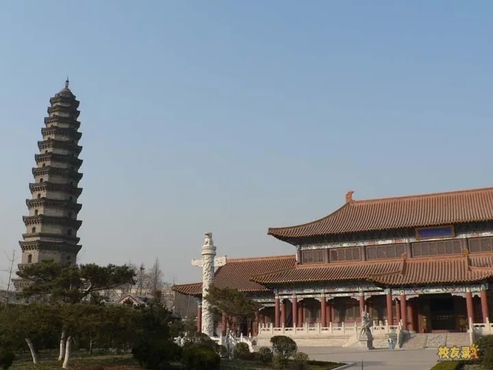 The courtyard of
 Plan your visit
Getting there
Wenshang County is about 35 km in a straight line from central Jining. Search for 汶上县 in a map app to find stations and your accommodation.
Where to stay →Build your route
Start with Baoxiang Temple. The linked place guides have entrance and visit details.
Continue with Jining →More in Jining
Sources & geographic information
Administrative names and parent areas: Official geographic directory · Reference date 2026-09-06.
Some facts checked against 汶上县 — Wikipedia contributors, CC BY-SA 4.0.
Photo: Baoxiang Temple · 枫行天下 · CC BY-SA 3.0. Full frame retained; proportionally resized and converted to WebP. No retouching or changes to the photographed subject. Card displays may crop the view.

Map data © OpenStreetMap contributors. Pins mark approximate centres, not entrances or boundaries.