


Get to know Burang County
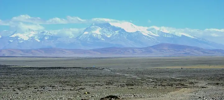
Photo adjustments
Full frame retained; resized proportionally to a maximum dimension of 960 pixels and converted to WebP quality 88. No crop, retouch, generated elements, or subject alteration. Final website rendition: full frame retained, proportionally resized to at most 720 pixels and converted to WebP. No additional retouching or subject alteration. Card displays may crop the view.
- Administrative area
- County · 县
- Part of
- Ngari Prefecture
- Chinese name
- 普兰县
- Local areas
- County guide
Area & population
- Area in the source
- 12,539.00 km²
- Population · 2020
- 12,242
Source: cited geographic source, as of the dates shown.
History
The area belonged in ancient times to the Zhangzhung (象雄) kingdom. Chinese texts of the Song and Yuan dynasties wrote its name as Burang (布让), and the Ming used the form Pulan. After 1959 the old Burang dzong (宗, a Tibetan district) became Burang County, with its government in Purang Town (普兰镇).
What to see
Mount Kailash rises in Bagar (巴嘎). Chinese Wikipedia gives its height as 6,638 m, the figure used by the Chinese Academy of Sciences, and calls it the second-highest peak of the Gangdise range (冈底斯山脉); the Sênggê Zangbo (狮泉河), the upper Indus, rises at its northern foot. Pilgrims walk around the mountain: Buddhists and Hindus go clockwise, followers of Bon anticlockwise. The outer circuit is about 52 km long, starting from Darchen (塔尔钦) on the south side and crossing the Drolma La pass (卓玛拉山口) at 5,648 m.
South of the mountain lie two lakes. Lake Manasarovar, revered by Hindus, Buddhists, Jains and Bon followers, is a freshwater lake about 88 km round, at about 4,600 m; it is a national nature reserve and is on China's World Heritage tentative list. A natural channel, the Ganga Chu (岗嘎曲), carries its water into the salt lake Lhanag Tso (拉昂错) beside it.
Khorchag Monastery (科迦寺) stands in Khorzhak village (科迦村) in Purang Town and is protected at the national level. The translator Rinchen Zangpo (仁钦桑布) founded it in 996; it first belonged to the Kadam (噶当派) school and later passed to the Sakya (萨迦派). Its main festival, on the twelfth day of the first Tibetan month, features masked dances, and in the sixth Tibetan month it shows its old thangka paintings, the only display of the year.
Food and local products
Khorzhak lies in the Peacock River (孔雀河) valley, where villagers grow highland barley (青稞) on fields above 3,800 m. The Zangqing 2000 variety was first trial-planted there in 2014, and the village has built a tsampa (糌粑, roasted barley flour) factory through its women's cooperative.
Highlights
- Mount Kailash 冈仁波齐峰: 6,638 m peak in Bagar; its outer pilgrim circuit is about 52 km and crosses the Drolma La at 5,648 m.
- Lake Manasarovar 玛旁雍错: Freshwater lake sacred to four religions; a national nature reserve on the World Heritage tentative list.
- Lhanag Tso 拉昂错: Salt lake beside Manasarovar, fed by the Ganga Chu channel.
- Khorchag Monastery 科迦寺: Sakya monastery founded in 996 by Rinchen Zangpo; protected at the national level.
Sources for this guide
普兰县 - 维基百科,自由的百科全书 · Chinese Wikipedia · CC BY-SA 4.0
走进普兰科迦村:孔雀河谷青稞迎来丰收季_普兰政府新闻网_阿里_西藏 · Burang County People's Government
玛旁雍错 - 维基百科,自由的百科全书 · Chinese Wikipedia · CC BY-SA 4.0
冈仁波齐峰 - 维基百科,自由的百科全书 · Chinese Wikipedia · CC BY-SA 4.0
科迦寺 - 维基百科,自由的百科全书 · Chinese Wikipedia · CC BY-SA 4.0
Original English written from the listed sources and checked sentence by sentence against quoted extracts by a separate reviewer. Updated 2026-09-25.
Entry & permits for Tibet (Xizang)
Foreign tourists need Tibet entry approval, commonly called a Tibet Travel Permit, and an organised visit arranged through a specialist travel agency in China. Confirm your approved route before booking transport. Requirements differ for Taiwan residents and for travellers using mainland or Hong Kong/Macao Chinese resident documents; check the document guide before you book.
Check the travel-document requirements →Policy scope verified: 2026-09-06. UK FCDO: China regional travel advice ↗ State Council Taiwan Affairs Office: Tibet entry approval ↗ Xizang Department of Culture and Tourism: Medog border permit notice ↗
Explore Burang County
Core places to explore, with English and Chinese names.
Places to explore around Burang County
 AI illustration · AI 示意图(仅供参考,非该地点实拍)
Mount Kailash Kora Route冈仁波齐正规开放转山线路
Mount Kailash (冈仁波齐) stands in Baga Township, Purang County, in the Ngari Prefecture of the Tibet Autonomous Region, and is 6,656 metres high. The Purang County guide commentary translates its Tibetan name as king of snow mountains and records it as revered by the indigenous Tibetan Bon religion, by Tibetan Buddhism, by Hinduism and by Jainism, and called the centre of the world.
Read the place guide → AI illustration · AI 示意图(仅供参考,非该地点实拍)
Rakshastal Lake Official Viewpoint拉昂错正规观景点
La'nga Co (拉昂错), the lake the sources call the ghost lake, lies in Purang County in the Ngari Prefecture of the Tibet Autonomous Region at 4,573 metres, a slightly brackish lake. The Purang County government's commentary on the county's scenic sites describes it as standing beside the sacred lake Manasarovar with only a channel between them.
Read the place guide → Lake Manasarovar · 玛旁雍措
Lake Manasarovar玛旁雍错
Manasarovar is a large freshwater lake in Burang, lying near Kailash and beside the contrasting saline waters of Rakshastal. Its religious significance extends across several Himalayan traditions, but the physical landscape is…
Read the place guide →Plan your visit
Getting there
Burang County is about 265 km in a straight line from central Ngari Prefecture. Search for 普兰县 in a map app to find stations and your accommodation.
Where to stay →Build your route
Mount Kailash Kora Route and Rakshastal Lake Official Viewpoint are both listed here. The linked place guides have entrance and visit details.
Continue with Ngari Prefecture →More in Ngari Prefecture
Sources & geographic information
Administrative names and parent areas: Official geographic directory · Reference date 2026-09-06.
Some facts checked against 普兰县 — Wikipedia contributors, CC BY-SA 4.0.
Some facts checked against 玛旁雍错 — Wikipedia contributors, CC BY-SA 4.0.
Some facts checked against 冈仁波齐峰 — Wikipedia contributors, CC BY-SA 4.0.
Some facts checked against 科迦寺 — Wikipedia contributors, CC BY-SA 4.0.
Photo: Lake Manasarovar · Jean-Marie Hullot · CC BY-SA 4.0. Wikimedia thumbnail; fitted to the ranking-card frame.

Map data © OpenStreetMap contributors. Pins mark approximate centres, not entrances or boundaries.