


Get to know Akto County
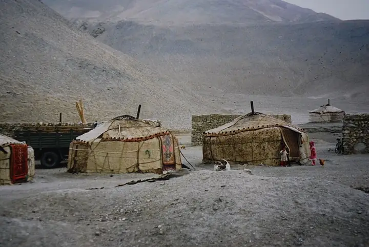
Photo adjustments
Full frame retained; resized proportionally to a maximum dimension of 960 pixels and converted to WebP quality 88. No crop, retouch, generated elements, or subject alteration. Final website rendition: full frame retained, proportionally resized to at most 720 pixels and converted to WebP. No additional retouching or subject alteration. Card displays may crop the view.
- Administrative area
- County · 县
- Part of
- Kizilsu Kyrgyz Autonomous Prefecture
- Chinese name
- 阿克陶县
- Local areas
- County guide
Area & population
- Area in the source
- 24,176.00 km²
- Population · 2020
- 226,005
Source: cited geographic source, as of the dates shown.
Setting and landscape
The county government counts three landscapes within its borders: the Pamirs, the northern slopes of the Kunlun (昆仑山) and the oases of the western Tarim Basin. Mountains cover 96.4 per cent of the land, rising from the northeast to the southwest. In the centre stands the Kongur massif (公格尔山), whose main summit reaches 7,719 metres and Kongur Tiube (公格尔九别峰) 7,530 metres, and Muztagh Ata (慕士塔格峰, 7,541 metres) stands on the boundary with Taxkorgan. More than 40 modern glaciers below the snowline feed the Gez (盖孜河) and Kushan (库山河) rivers, and the county lists snow lotus, snow leopards and argali among the rare species of its mountains.
What to see
Kizilsu Glacier Park (克州冰川公园), in Oytagh Town (奥依塔克镇) about 85 kilometres from the county seat, has been a national 4A scenic area since April 2011 and spans 2,300 to 5,300 metres. The snow peak of Ayilanish (阿依拉尼什雪山, 6,684 metres) feeds the source of the Oytagh River (奥依塔克河), and the Qikelaz glacier (其克拉孜冰川), whose tongue reaches down into the forest belt, is described by the county as one of China's lowest modern glaciers, at 2,800 metres.
The county also has the Karakul Lake (喀拉库勒湖) scenic area and the Baisha Mountain and Baisha Lake (白沙山白沙湖) scenic area, both under its culture and tourism bureau. The county's own description of the lakes at the foot of Muztagh Ata has their water shifting between green, black, blue, pale yellow and orange.
Fruit and local products
The oasis is known in Xinjiang for its fruit, and the county names Baren apricots (巴仁杏), pomegranates, blood plums and pale, translucent Munage grapes (木纳格葡萄) among its harvest, with mulberries ripening in May, apricots in June and melons still eaten beside the stove in winter.
Getting oriented
The county was formed in 1955 from parts of Taxkorgan, Yengisar (英吉沙县), Shufu (疏附县) and Wuqia (乌恰县) counties. Its border with Kyrgyzstan and Tajikistan runs for 380 kilometres, and Chinese Wikipedia puts it 37 kilometres from Kashgar (喀什市).
Highlights
- Kizilsu Glacier Park 克州冰川公园: National 4A scenic area (2011) in Oytagh Town with the low-lying Qikelaz glacier.
- Kongur Tiube 公格尔九别峰: 7,530-metre peak of the Kongur massif in the centre of the county.
- Karakul Lake 喀拉库勒湖: Lake scenic area under the county culture and tourism bureau.
- Baisha Mountain and Baisha Lake 白沙山白沙湖: Lake scenic area of the county under its culture and tourism bureau.
- Baren apricots 巴仁杏: Yellow apricots named among the county's oasis harvest.
Sources for this guide
群山聚首的帕米尔高原 · Akto County People's Government
克州冰川公园景区 · Akto County People's Government (county culture, sports, radio, television and tourism bureau)
关于禁止在白沙山白沙湖景区、喀拉库勒湖景区湖上游玩的公告 · Akto County People's Government
璀璨明珠——阿克陶 · Akto County People's Government
四季飘香的瓜果之乡 · Akto County People's Government
阿克陶县 - 维基百科,自由的百科全书 · Wikipedia · CC BY-SA 4.0
Original English written from the listed sources and checked sentence by sentence against quoted extracts by a separate reviewer. Updated 2026-09-25.
Explore Akto County
Core places to explore, with English and Chinese names.
Places to explore around Akto County
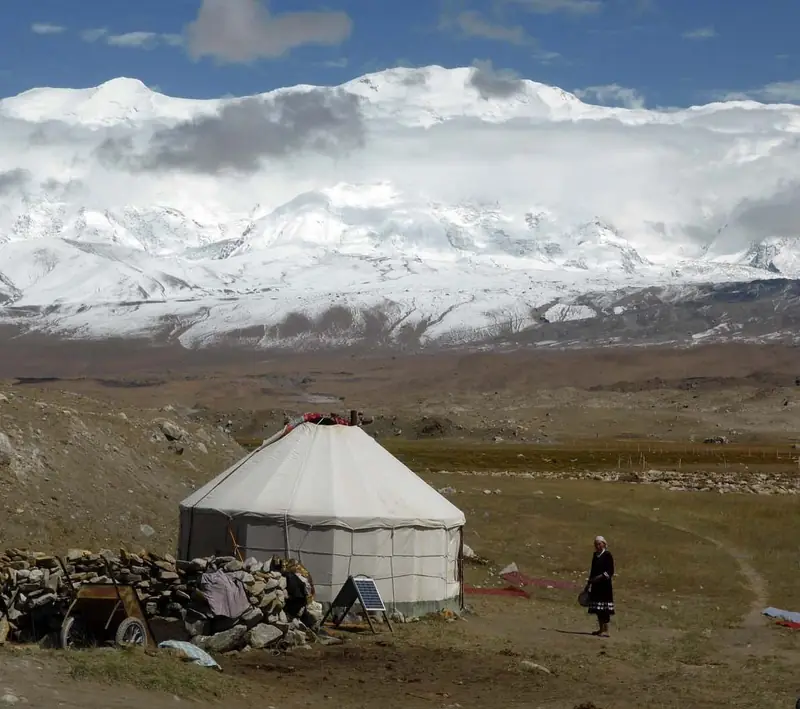 Kongur Tiube Peak Highway Viewpoint · 公格尔九别峰公路观景
Kongur Tiube Peak Highway Viewpoint公格尔九别峰公路观景
Gongger Jiubiefeng Highway Viewpoint (公格尔九别峰公路观景) is the catalogue's entry for a highway viewing place at Kongur Tiubie peak in Akto County, Kizilsu Kirghiz Autonomous Prefecture, Xinjiang; no page cited here names a viewpoint, a viewing platform or a designated viewing place, but the prefecture's account says the China–Pakistan international highway runs past the foot of the peak and that the ice formations on the peaks are clearly visible from that road.
Read the place guide →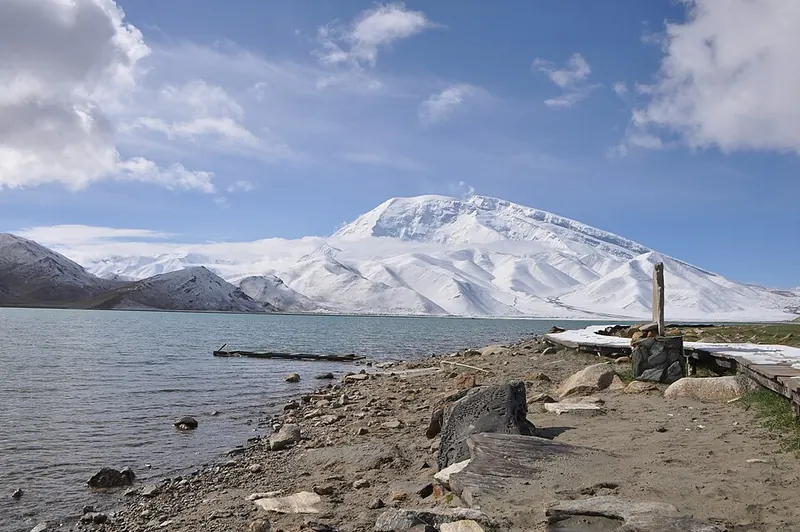 Karakul Lake with Muztagh Ata behind · 喀拉库勒湖 Photograph date recorded by the source: 2012-06-17 11:01:55.
Karakul (China)喀拉库勒湖
Karakul in Akto County is a high-altitude lake beside the Karakoram Highway, with Muztagh Ata and the Kongur mountain group forming its wider setting. Still conditions can create striking reflections, while wind changes the…
Read the place guide → AI illustration · AI 示意图(仅供参考,非该地点实拍)
Oytagh Glacier Park奥依塔克冰川公园
Oytagh Glacier Park, also called Kizilsu Glacier Park, combines glacier scenery with conifer forest, grassland and snow-covered mountains. The approach branches away from the main Pamir highway into the mountains west of Oytagh…
Read the place guide → Baisha Lake and Baisha Mountain Viewing Area · 白沙湖与白沙山正规观景区
Baisha Lake and Baisha Mountain Viewing Area白沙湖与白沙山正规观景区
Baisha Lake and Baisha Mountain (白沙湖与白沙山) is a scenic area in Bulunkou township, Akto County, Kizilsu Kirghiz Autonomous Prefecture, Xinjiang — a township the county's gazetteer places on the Pamir; the county's own pages call the area 白沙山—白沙湖景区 and describe it as silvery-white sand hills set against deep blue water.
Read the place guide →Plan your visit
Getting there
Akto County is about 65 km in a straight line from central Kizilsu Kyrgyz Autonomous Prefecture. Search for 阿克陶县 in a map app to find stations and your accommodation.
Where to stay →Build your route
Kongur Tiube Peak Highway Viewpoint and Karakul (China) are both listed here. The linked place guides have entrance and visit details.
Continue with Kizilsu Kyrgyz Autonomous Prefecture →More in Kizilsu Kyrgyz Autonomous Prefecture
Sources & geographic information
Administrative names and parent areas: Official geographic directory (dmfw.mca.gov.cn) · Reference date 2026-09-06.
Some facts checked against 阿克陶县 — Wikipedia contributors, CC BY-SA 4.0.
Photo: Kongur Tiube Peak Highway Viewpoint · Source photographer · License not provided. EXIF orientation normalized; resized without changing aspect ratio; converted to WebP. No subject edits.
Photo: Karakul (China) · Yoshi Canopus · CC BY-SA 3.0. Full frame retained; proportionally resized and converted to WebP. No retouching or changes to the photographed subject. Card displays may crop the view.

Photo: Baisha Lake and Baisha Mountain Viewing Area · Source photographer · License not provided. EXIF orientation normalized; resized without changing aspect ratio; converted to WebP. No subject edits.
Map data © OpenStreetMap contributors. Pins mark approximate centres, not entrances or boundaries.