


Get to know Dingyuan County
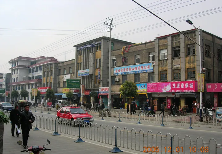
Photo adjustments
Full frame retained; proportionally resized and converted to WebP. No retouching or changes to the photographed subject. Card displays may crop the view.
- Administrative area
- County · 县
- Part of
- Chuzhou
- Chinese name
- 定远县
- Local areas
- County guide
Area & population
- Area in the source
- 2,998.00 km²
- Population · 2017
- 974,900
Source: cited geographic source, as of the dates shown.
Setting and landscape
The county belongs to the Jianghuai hills (江淮丘陵) and slopes from north to south, nowhere above 350 metres. Hills line the north and east, most of the county is rolling plain dotted with low knolls, and a narrow valley plain follows the Chi River. Gaotang Lake (高塘湖), its only lake, is a long narrow strip on the western border shared with Fengyang (凤阳), Changfeng (长丰) and Huainan (淮南); the town of Luqiao (炉桥镇) stands on its shore.
History
The Houjiazhai site (侯家寨遗址), found in 1978 and excavated in 1985, gave its name to the Houjiazhai culture, an early prehistoric culture of the Yangtze–Huai region. Under the Qin the area held the counties of Yinling (阴陵) and Dongcheng (东城), and Xiang Yu (项羽) crossed it after his defeat at Gaixia (垓下). The name Dingyuan, "settling the distant lands", dates from 524, when the Liang general Cao Shizong (曹世宗) recovered territory south of the Huai and three counties became Dingyuan commandery and county; the seat moved to Dingcheng (定城) in 745 and has barely moved since.
In the war against Japan, the county was where the eastern Anhui base area began and lay at the centre of the Huainan base. Liu Shaoqi (刘少奇), under the alias Hu Fu, arrived near Outang on 29 November 1939 and held several meetings of the Party's Central Plains Bureau (中原局) there.
What to see
The tomb of Yu Ji, locally Jiexu Dun (嗟虞墩), is a large earth mound beside Tan village in Erlong (二龙) township, 30 kilometres south of the county town, with a stele naming her as consort of the Hegemon-King of Western Chu; Su Shi (苏轼) and Su Zhe (苏辙) both wrote poems on it. The Outang Martyrs' Cemetery and the Central Plains Bureau meeting site were named in 2004 among China's hundred classic red-tourism sites. At Luqiao the Ming five-arched Qiaoshangqiao (桥上桥), "bridge on a bridge", was found in 1984 to stand over an older red-stone slab bridge. Taiping Bridge (太平桥) at Chihe (池河镇), built in the Ming for the post road between Nanjing and Fengyang, has 32 carved lions on its white stone railings.
Food and local products
Local specialities include Dingyuan qiaowei (定远桥尾), brined old goose (卤老鹅), Luqiao knife-cut noodles (炉桥小刀面), Chihe snowflake cake (池河雪片糕) and meibai fish (梅白鱼).
Getting oriented
The Beijing–Shanghai high-speed railway, the Huainan railway and the Hefei–Xuzhou expressway (G3) cross the county. Outang lies 35 kilometres southeast of the county town.
Highlights
- Tomb of Yu Ji 虞姬墓: Earth mound in Erlong township identified with the consort of Xiang Yu; Su Shi and Su Zhe wrote poems on it.
- Houjiazhai Site 侯家寨遗址: Mound excavated in 1985 that names the Houjiazhai prehistoric culture.
- Qiaoshangqiao 桥上桥: Ming five-arched bridge at Luqiao built over an older red-stone bridge.
- Outang Martyrs' Cemetery 藕塘烈士陵园: Listed in 2004 among China's hundred classic red-tourism sites.
Sources for this guide
定远县 - 维基百科,自由的百科全书 · Chinese Wikipedia · CC BY-SA 4.0
历史沿革_定远县人民政府 · Dingyuan County People's Government (county Party history and local gazetteer office)
自然地理_定远县人民政府 · Dingyuan County People's Government (county Party history and local gazetteer office)
定远县境内主要文物名胜 · Dingyuan County Committee of the CPPCC (local history materials)
发展红色旅游 彰显定远特色 · Dingyuan County Committee of the CPPCC
Original English written from the listed sources and checked sentence by sentence against quoted extracts by a separate reviewer. Updated 2026-09-23.
Explore Dingyuan County
Core places to explore, with English and Chinese names.
Dingyuan County 定远县
Plan your visit
Getting there
Dingyuan County is about 75 km in a straight line from central Chuzhou. Search for 定远县 in a map app to find stations and your accommodation.
Where to stay →More in Chuzhou
Sources & geographic information
Administrative names and parent areas: Official geographic directory · Reference date 2026-09-06.
Some facts checked against 定远县 — Wikipedia contributors, CC BY-SA 4.0.
Map data © OpenStreetMap contributors. Pins mark approximate centres, not entrances or boundaries.