


Get to know Fengyang County
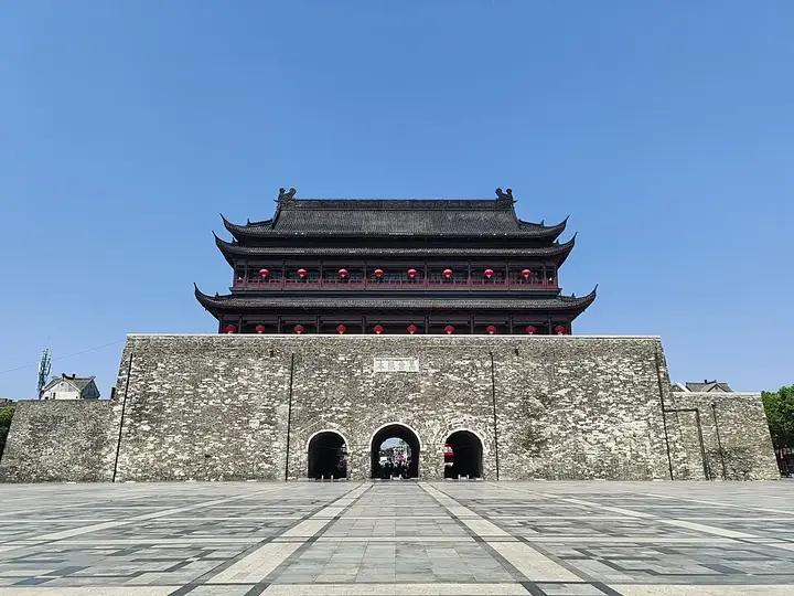
Photo adjustments
Full frame retained; resized proportionally to a maximum dimension of 960 pixels and converted to WebP quality 88. No crop, retouch, generated elements, or subject alteration. Final website rendition: full frame retained, proportionally resized to at most 720 pixels and converted to WebP. No additional retouching or subject alteration. Card displays may crop the view.
- Administrative area
- County · 县
- Part of
- Chuzhou
- Chinese name
- 凤阳县
- Local areas
- County guide
Area & population
- Area in the source
- 1,949.50 km²
- Population · 2018
- 683,200
Source: cited geographic source, as of the dates shown.
Setting and landscape
The county's own description runs "hills in the south, water in the north, and rolling land with flat valleys in between" (南是山,北是湾,中间丘陵夹平川). Uplands and low hills cover 85.7 per cent of the county, part of the hill country between the Yangtze and Huai; the land falls from eroded hills in the south to a flat alluvial plain in the north; the Huai runs 52.5 kilometres through the county. The climate sits between the northern subtropics and the southern temperate zone.
History
In the Spring and Autumn period this was the state of Zhongli (钟离), and the county government links it to the "fish in the Hao River" (濠梁观鱼) dialogue between Zhuangzi (庄子) and Hui Shi (惠施). From 582 it was Haozhou (濠州). In 1369 Zhu Yuanzhang ordered a Middle Capital (中都) built here with walls and palaces on the model of the capital; in 1374 he moved the prefecture seat to the south side of Phoenix Hill (凤凰山) and gave his home town the name Fengyang. Bengbu (蚌埠) was split off from the county in 1947, and Fengyang has belonged to Chuzhou since 1993.
What to see
The site of the Ming Middle Capital (明中都皇故城遗址) and the stone carvings of the Ming Imperial Tomb (明皇陵) are listed together as a national protected site. The tomb, 7 kilometres south of the county town, was built between 1366 and 1379 for Zhu Yuanzhang's parents; its spirit way is lined with 28 pairs of stone carvings, among them qilin, lions, tigers, rams, civil officials, generals and eunuchs. The restored Hongwu Gate (洪武门), the southern gate of the Middle Capital's outer wall, anchors the old north-south axis together with the Daming Gate (大明门), the Chengtian Gate (承天门) and the Meridian Gate (午门).
At Xiaogang village, eighteen red fingerprints opened China's rural reform, in the county government's words, and the leaders of the village's dabaogan (大包干) contracting were honoured as a group with the title "Reform Pioneers" (改革先锋).
Food and local products
Fengyang flower-drum singing (凤阳花鼓), probably formed in the Ming, is on the first national intangible-heritage list of 2006; one or two performers sing while beating a small drum and gong, and performers who took it on the road to beg spread it across China. Local products named by the county include Fengyang peanuts (凤阳花生), Meishi salted goose (梅市盐水鹅), Fengyang vine tea (凤阳藤茶), Huayuan Lake hairy crab (花园湖大闸蟹) and Huangnipu grapes (黄泥铺葡萄).
Highlights
- Ming Middle Capital site 明中都皇故城遗址: Capital begun by Zhu Yuanzhang in 1369; national protected site.
- Ming Imperial Tomb 明皇陵: Tomb of Zhu Yuanzhang's parents, 7 km south of the county town, with 28 pairs of stone carvings on its spirit way.
- Xiaogang village 小岗村: Called by the county government the main birthplace of China's rural reform.
- Hongwu Gate 洪武门: Restored southern gate of the Middle Capital's outer wall.
- Fengyang flower-drum singing 凤阳花鼓: National intangible heritage since 2006.
Sources for this guide
凤阳概况_凤阳县人民政府 · Fengyang County People's Government (Fengyang Culture and Tourism Bureau)
历史人文_凤阳县人民政府 · Fengyang County People's Government
自然地理_凤阳县人民政府 · Fengyang County People's Government
洪武门_凤阳县人民政府 · Fengyang County People's Government
凤阳花鼓 - 中国非物质文化遗产网·中国非物质文化遗产数字博物馆 - 中国非物质文化遗产网非遗 · China Intangible Cultural Heritage Network (ihchina.cn)
明皇陵 - 维基百科,自由的百科全书 · Chinese Wikipedia · CC BY-SA 4.0
Original English written from the listed sources and checked sentence by sentence against quoted extracts by a separate reviewer. Updated 2026-09-25.
Explore Fengyang County
Core places to explore, with English and Chinese names.
Places to explore around Fengyang County
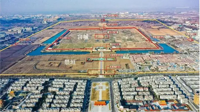 Ming Zhongdu Imperial City Ruins · 明中都皇故城遗址
Ming Zhongdu Imperial City Ruins明中都皇故城遗址
Ming Zhongdu in Fengyang preserves the walls, gate platforms and other remains of the imperial capital that Zhu Yuanzhang began building in his home region in 1369.
Read the place guide →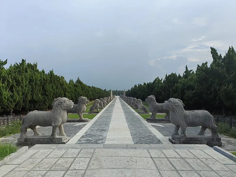 Stone animals lining the sacred way at the Ming Imperial Tombs in Fengyang. Photograph date recorded by the source: 2024-08-08 16:41:45.
Ming Imperial Tombs (Fengyang)明皇陵
The Ming Imperial Tombs near Fengyang were built by Zhu Yuanzhang for his parents between 1366 and 1379. They lie south of the county town, separate from the imperial mausoleums near Nanjing and Beijing.
Read the place guide → Xiaogang Village · 小岗村
Xiaogang Village小岗村
Fengyang County village where 18 farmers split collective land into family plots in 1978, now a national protected site with a reform museum.
Read the place guide →Plan your visit
Getting there
Fengyang County is about 100 km in a straight line from central Chuzhou. Search for 凤阳县 in a map app to find stations and your accommodation.
Where to stay →Build your route
Ming Zhongdu Imperial City Ruins and Ming Imperial Tombs (Fengyang) are both listed here. The linked place guides have entrance and visit details.
Continue with Chuzhou →More in Chuzhou
Sources & geographic information
Administrative names and parent areas: Official geographic directory (dmfw.mca.gov.cn) · Reference date 2026-09-06.
Some facts checked against 明皇陵 — Wikipedia contributors, CC BY-SA 4.0.
Photo: Ming Zhongdu Imperial City Ruins · Source photographer · License not provided. EXIF orientation normalized; resized without changing aspect ratio; converted to WebP. No subject edits.
Photo: Ming Imperial Tombs (Fengyang) · Yumeto · CC BY-SA 4.0. Full frame retained; proportionally resized and converted to WebP. No retouching or changes to the photographed subject. Card displays may crop the view.

Photo: Xiaogang Village · luchangjiang~鲁昌江 · CC BY-SA 3.0. EXIF orientation normalized; resized without changing aspect ratio; converted to WebP. No subject edits.

Map data © OpenStreetMap contributors. Pins mark approximate centres, not entrances or boundaries.