


Get to know Jinta County

Photo adjustments
EXIF orientation normalized; resized without changing aspect ratio; converted to WebP. No subject edits.
- Administrative area
- County · 县
- Part of
- Jiuquan
- Chinese name
- 金塔县
- Local areas
- County guide
Area & population
- Area in the source
- 18,800.00 km²
- Population · 2017
- 145,600
- Administrative seat
- Jinta Town
Source: cited geographic source, as of the dates shown.
Setting and landscape
Hills close the county in on the east, south and north, and the low, flat Jinta Basin (金塔盆地) in the middle sits at 1,100 to 1,300 metres. The east and south-east reach into the edge of the Badain Jaran Desert (巴丹吉林沙漠) and the Heli Mountains (合黎山), and the west is gobi desert. Neighbours are Gaotai County (高台县) to the east, Yumen (玉门市) to the west, and Suzhou District (肃州区) and Jiayuguan (嘉峪关市) to the south.
The climate is dry and continental, with an annual mean of 9.4°C and only 39 millimetres of rain a year. The Heihe and the Taolai River (讨赖河), both rising in the glaciers of the Qilian Mountains (祁连山), bring water into the county, which has twelve reservoirs, among them Yuanyangchi (鸳鸯池).
History
In 111 BC the Han created Huishui County (会水县) here under Jiuquan Commandery (酒泉郡). In 421 Juqu Mujian (沮渠牧犍), eldest son of the Northern Liang (北凉) king, set up a herding estate in the west of the county, later called Wangzizhuang (王子庄), the prince's estate. In 1913 the county was renamed Jinta after the Jinta Temple (金塔寺) south-east of the town, and in March 1956 neighbouring Dingxin County (鼎新县) was merged into it.
What to see
Dawan (大湾城), Diwan (地湾城) and the Jianshui Jinguan pass (肩水金关) are national key protected sites. The Juyan Han slips (居延汉简) excavated there are listed among the four great Chinese archaeological discoveries of the 20th century.
The Jinta Desert Poplar Forest (金塔沙漠胡杨林) was developed as a scenic area in 2009 around ten thousand mu of desert poplars and is now a national 4A scenic area; the trees turn gold in October. A road built in 2021 runs from the forest to the Heihe Loop (黑河环流), one of the "Eight Views of Jinta" (金塔八景), where sand desert and gobi alternate; the Heihe runs for 150 kilometres through the county. In Hongguang village (红光村), Jinta town, apricot trees fill the village and have been made the basis of a rural tourism area.
Highlights
- Jinta Desert Poplar Forest 金塔沙漠胡杨林: Developed in 2009 around ten thousand mu of desert poplars; a national 4A scenic area, golden in October.
- Jianshui Jinguan pass 肩水金关: National key protected site where Juyan Han slips were excavated.
- Heihe Loop 黑河环流: One of the Eight Views of Jinta, among desert and gobi, reached by a road built in 2021.
Sources for this guide
金塔县县情简介 · Jinta County People's Government
自然地理 · Jinta County People's Government
历史沿革 · Jinta County People's Government
旅游资源 · Jinta County People's Government
Original English written from the listed sources and checked sentence by sentence against quoted extracts by a separate reviewer. Updated 2026-09-23.
Explore Jinta County
Core places to explore, with English and Chinese names.
Places to explore around Jinta County
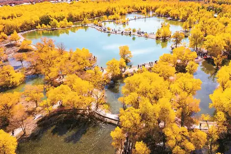 Jinta Desert Poplar Forest ·
 Plan your visit
Getting there
Jinta County is about 45 km in a straight line from central Jiuquan. Search for 金塔县 in a map app to find stations and your accommodation.
Where to stay →Build your route
Start with Jinta Desert Poplar Forest. The linked place guides have entrance and visit details.
Continue with Jiuquan →More in Jiuquan
Sources & geographic information
Administrative names and parent areas: Official geographic directory · Reference date 2026-09-06.
Photo: Jinta Desert Poplar Forest · Source photographer · License not provided. EXIF orientation normalized; resized without changing aspect ratio; converted to WebP. No subject edits.
Map data © OpenStreetMap contributors. Pins mark approximate centres, not entrances or boundaries.