


Get to know Aksay Kazak Autonomous County
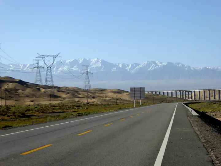
Photo adjustments
Full frame retained; proportionally resized and converted to WebP. No retouching or changes to the photographed subject. Card displays may crop the view.
- Administrative area
- Autonomous county · 自治县
- Part of
- Jiuquan
- Chinese name
- 阿克塞哈萨克族自治县
- Local areas
- Autonomous county guide
Area & population
- Area in the source
- 31,374.00 km²
- Population · 2020
- 10,970
- Administrative seat
- Jengghelde (Hongliuwan)
Source: cited geographic source, as of the dates shown.
Setting and landscape
The county is a long strip, 425 kilometres east to west, rising from 1,500 metres in the northwest to 5,798 metres in the southeast. Five ranges, among them the Altun Mountains (阿尔金山) and the Danghe Nanshan (党河南山), run northwest to southeast around it, with permanent snow and glaciers above the snowline. Between them the Sugan Lake basin (苏干湖盆地) spreads gobi and desert at 2,800 to 3,000 metres. The Greater and Lesser Harteng rivers (哈尔腾河) feed the two Sugan lakes: the larger is salt, the smaller fresh. Rainfall ranges from 18.8 to 176 millimetres a year, and the county's wildlife includes wild camels, wild yaks, argali and snow leopards.
History
In ancient times the area belonged to Sanwei (三危); the Yuezhi and Wusun grazed here in the Warring States, Qin and Han periods, and the Tang placed it under Shazhou (沙州). Aksay's Kazakhs came from the Altay, Hami and Barkol areas of Xinjiang, moving into Gansu and Qinghai as herders from the early 20th century. The autonomous county was founded in April 1954 with its seat at Boluozhuanjing (博罗转井), and in 1998 the whole seat moved to Hongliuwan (红柳湾镇), today's county town.
What to see
The former seat at Boluozhuanjing is now the old county town film base, where films including Jiuceng Yaota (九层妖塔) were shot. In Duobagou (多坝沟), a fertile, irrigated farming valley, the Euphrates poplar gorge turns gold in autumn against red, wind-carved sandstone, and an old beacon-tower site stands among the trees. The Haizi grassland (海子草场), named from the Kazakh word for lake, is one of the county's three main pastures. Kazakh felt yurts serve as places to eat Kazakh food and watch traditional song and dance, and the county lists 102 intangible heritage items, and schools run heritage clubs for the dombra (冬不拉) and Kara Zhorga (黑走马).
Highlights
- Old county town film base 阿克塞老县城: The county seat at Boluozhuanjing until 1998, now a film base.
- Duobagou poplar gorge 多坝沟胡杨峡: Euphrates poplars and red sandstone cliffs, with an old beacon-tower site.
- Sugan lakes 苏干湖: A salt lake and a fresh lake fed by the Harteng rivers in a high basin at 2,800–3,000 m.
Sources for this guide
阿克塞哈萨克族自治县概况 · Aksay Kazak Autonomous County People's Government
阿克塞之旅:探索古西域秘密与现代文化交融 · Aksay County Media Centre (Aksay County People's Government portal)
【非凡“十四五”】阿克塞:“非遗+”出文旅新天地 · Aksay County Media Centre (Aksay County People's Government portal)
金秋秘境:阿克塞多坝沟胡杨峡的赤色浪漫 · Aksay County Media Centre (Aksay County People's Government portal)
Original English written from the listed sources and checked sentence by sentence against quoted extracts by a separate reviewer. Updated 2026-09-23.
Explore Aksay Kazak Autonomous County
Core places to explore, with English and Chinese names.
Places to explore around Aksay Kazak Autonomous County
 Aksay Old County Town Ruins ·
 Plan your visit
Getting there
Aksay Kazak Autonomous County is about 355 km in a straight line from central Jiuquan. Search for 阿克塞哈萨克族自治县 in a map app to find stations and your accommodation.
Where to stay →Build your route
Start with Aksay Old County Town Ruins. The linked place guides have entrance and visit details.
Continue with Jiuquan →More in Jiuquan
Sources & geographic information
Administrative names and parent areas: Official geographic directory · Reference date 2026-09-06.
Photo: Aksay Old County Town Ruins · Source photographer · License not provided. EXIF orientation normalized; resized without changing aspect ratio; converted to WebP. No subject edits.
Map data © OpenStreetMap contributors. Pins mark approximate centres, not entrances or boundaries.