


Get to know Handan
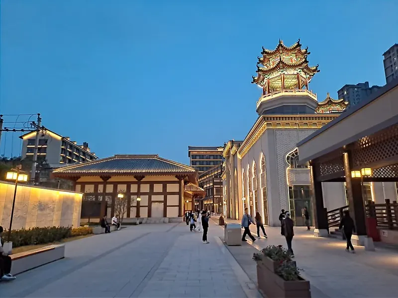
Photo adjustments
Full frame retained; proportionally resized and converted to WebP. No retouching or changes to the photographed subject. Card displays may crop the view.
- Administrative area
- Prefecture-level city · 地级市
- Part of
- Hebei
- Chinese name
- 邯郸市
- Local areas
- 18 local areas
Area & population
- Area in the source
- 12,068.00 km²
- Population · 2020
- 9,433,000
- Administrative seat
- Congtai District
Source: cited geographic source, as of the dates shown.
Setting and landscape
The land steps down from west to east. The Beijing–Guangzhou railway roughly divides the western mountains and hills from the plain, which covers more than two-thirds of the prefecture. Its rivers, among them the Zhang (漳河), Wei (卫河) and Fuyang (滏阳河), belong to the Hai River (海河) system.
History
People lived near Cishan (磁山) more than 8,000 years ago, and the city government describes it as an origin of foxtail millet cultivation. The name Handan first appears in the Bamboo Annals (竹书纪年), which record palaces built here by the last Shang king. In 386 BC Handan became the capital of the state of Zhao (赵), whose King Wuling (赵武灵王) introduced nomad dress and mounted archery. In 213 Cao Cao (曹操) made Ye (邺城), in today's Linzhang (临漳), his capital, and Ye later served five northern dynasties; in 1042 the Song made Daming (大名) its secondary northern capital. During the war against Japan, She County (涉县) housed the headquarters of the Eighth Route Army's 129th Division.
What to see
Guangfu Ancient City (广府古城) in Yongnian (永年) is the birthplace of Yang-style (杨式) and Wu-style (武式) tai chi, both on the national intangible-heritage list and inscribed by UNESCO in 2020 as part of Chinese tai chi; the town became a national 5A scenic area in 2017. Wahuang Palace (娲皇宫) in She County, rated 5A in 2015, marks where legend says the goddess Nüwa (女娲) mended the sky and shaped people from clay, and keeps six Buddhist sutras carved into the cliff in the Northern Qi. The city government calls the Xiangtangshan Caves (响堂山石窟) the largest cave temple of the Northern Qi. In the city centre, the Handan Road historic district (邯郸道), opened in 2025, links the Wuling Congtai terrace (武灵丛台) with the Xuebu Bridge (学步桥) of the idiom 'learning to walk in Handan' (邯郸学步).
Food and local products
The city credits Cizhou ware (磁州窑), dating to the Northern Song, with pioneering black painting on a white ground. Local dishes named by the city include Ermao roast chicken from Daming (大名二毛烧鸡), Guoba huoshao (郭八火烧), Wu'an pulled noodles (武安拽面), Cixian smoked chicken (磁县熏鸡) and Wei County big-pot stew (魏县大锅菜). Daming's stone-milled sesame oil (大名小磨香油) joined the national intangible-heritage list in 2021.
Getting oriented
Handan is about 200 kilometres from the provincial capitals Shijiazhuang, Taiyuan, Jinan and Zhengzhou. Handan Airport lies 10 kilometres south of the city centre.
Highlights
- Guangfu Ancient City 广府古城: Birthplace of Yang-style (杨式) and Wu-style (武式) tai chi; national 5A scenic area since 2017.
- Wahuang Palace 娲皇宫: Nüwa shrine in She County with six Northern Qi sutras carved into the cliff; 5A since 2015.
- Xiangtangshan Caves 响堂山石窟: Called by the city the largest cave temple of the Northern Qi.
- Da Ming Er Mao Shao Ji 大名二毛烧鸡: Daming roast chicken named in the city's food list.
- Wu An Zhuai Mian 武安拽面: Pulled noodles from Wu'an named by the city government.
Sources for this guide
综合概况 - 邯郸市人民政府 · Handan Municipal People's Government
历史沿革 - 邯郸市人民政府 · Handan Municipal People's Government
地理环境 - 邯郸市人民政府 · Handan Municipal People's Government
历史文化 - 邯郸市人民政府 · Handan Municipal People's Government
风景名胜 - 邯郸市人民政府 · Handan Municipal People's Government
美食特产 - 邯郸市人民政府 · Handan Municipal People's Government
交通运输 - 邯郸市人民政府 · Handan Municipal People's Government
文化和旅游部数据服务栏目 (5A级旅游景区) · Ministry of Culture and Tourism of the People's Republic of China
Original English written from the listed sources and checked sentence by sentence against quoted extracts by a separate reviewer. Updated 2026-10-01.
Explore Handan
Core places to explore, with English and Chinese names.
Wahuang Palace 娲皇宫
Guangfu Ancient City 广府古城
Xiangtangshan Caves 响堂山石窟
Handan Museum 邯郸市博物馆
Zhaowangcheng Ruins Park 赵王城遗址公园
Congtai Park 丛台公园
Daming Ancient City 大名古城
East Taihang Scenic Area 东太行
Qibugou Valley 七步沟
Jingniang Lake 京娘湖
Eighth Route Army 129th Division Headquarters Site 八路军一二九师司令部旧址
Hanshan District 邯山区
Congtai District 丛台区
Fuxing District 复兴区
Fengfeng Mining District 峰峰矿区
Feixiang District 肥乡区
Yongnian District 永年区
Linzhang County 临漳县
Cheng'an County 成安县
Daming County 大名县
Shexian 涉县
Cixian 磁县
Qiuxian 邱县
Jize County 鸡泽县
Guangping County 广平县
Guantao County 馆陶县
Weixian 魏县
Quzhou County 曲周县
Wu'an 武安市
Places to explore around Handan
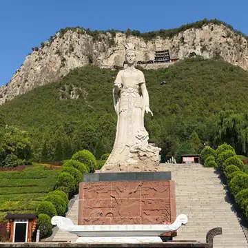 Wahuanggong ("Palace of the Goddess Nüwa")
Wahuang Palace娲皇宫
Wahuang Palace clings to Fenghuang Mountain in She County, with temple buildings set against a cliff and above steep drops. The site brings together the worship of Nüwa with older Buddhist material: Northern Qi scriptures were…
Read the place guide → A historic gate and city wall at Guangfu Ancient City in Hebei. Photographed on 16 April 2012.
Guangfu Ancient City广府古城
Guangfu's brick walls and water-rich surroundings preserve the outline of a fortified town on the Yongnian plain. Inside and beside those walls, courtyard houses connect the town with the development of Yang- and Wu-style…
Read the place guide → The stone approach and entrance structures at the northern Xiangtangshan Grottoes. Photographed on 7 May 2025.
Xiangtangshan Caves响堂山石窟
Xiangtangshan's Buddhist caves were cut into dense limestone during the sixth-century Northern Qi period. The northern group on Mount Gu contains large central-pillar chambers, while other groups occupy separate sites. Look at…
Read the place guide → The contemporary Handan Museum building · 邯郸市博物馆现馆建筑 Source-recorded photograph date: 2025-05-06 11:44:09.
Handan Museum邯郸市博物馆
Handan Museum connects the city's early history with two distinctive regional traditions: Cizhou ceramics and stone carving. Its historical survey supplies the setting for Handan's changing role, while the specialist galleries…
Read the place guide →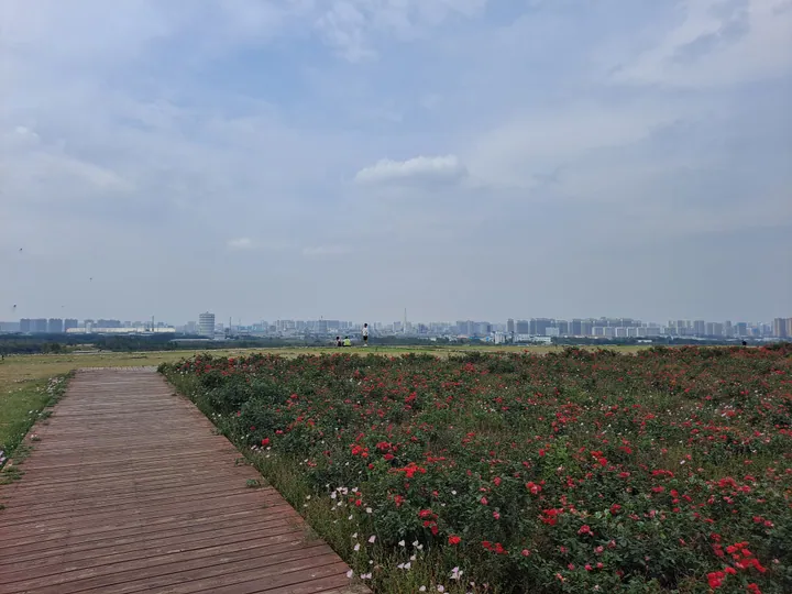 A rose garden atop the earthen ruins mound at Zhaowangcheng Ruins Park, Handan · 邯郸赵王城遗址公园夯土台上的玫瑰花田与城市远景 Source-recorded photograph date: 2025-05-31 14:38:50.
Zhaowangcheng Ruins Park赵王城遗址公园
Zhaowangcheng preserves the earthwork outline of the Zhao royal city rather than a standing ancient palace. The archaeological complex had eastern, western and northern compounds, with substantial platforms and rammed-earth…
Read the place guide →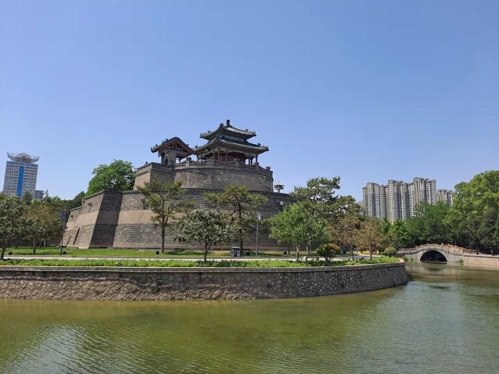 The Wuling Congtai terrace and pavilion within Congtai Park, Handan · 邯郸丛台公园内的武灵丛台 Source-recorded photograph date: 2025-05-06 13:23:58.
Congtai Park丛台公园
Handan's historic park built around Wuling Congtai, a Zhao-era terrace rebuilt under the Qing, with a lake pavilion, shrine and stele forest.
Read the place guide → The Ti Ren Men east gate tower of Da Ming Gu Cheng (Daming Ancient City), Daming County · 大名县大名古城体仁门(东门) Source-recorded photograph date: 2014-04-25.
Daming Ancient City大名古城
Daming Ancient City (大名古城) is Daming County's Ming-Qing walled city, built at a new site after flooding buried the older Damingfu settlement in 1401.
Read the place guide → A tall isolated rock pillar with a cliffside walkway at East Taihang Scenic Area, Wu'an · 武安市东太行景区悬崖栈道与石柱 Source-recorded photograph date: 2025-06-02 11:42:02.
East Taihang Scenic Area东太行
East Taihang Scenic Area (东太行) is a mountain scenic area in Wu'an distinguished by red quartz-sandstone peaks and paths fixed high on the cliffs.
Read the place guide → A waterfall and boardwalk along the lake at Qibugou Valley scenic area, Wu'an · 武安市七步沟景区湖畔栈道与瀑布 Source-recorded photograph date: 2015-07-04 12:52:25.
Qibugou Valley七步沟
Qibugou Valley (七步沟) is a mountain-valley scenic area in Wu'an's Huoshui area, combining waterfalls, forest and named rock formations.
Read the place guide → Tour boats moored on Jingniang Lake lake between forested hills, Wu'an · 武安京娘湖,游船停靠,两岸青山环绕 Source-recorded photograph date: 2025-06-02 07:24:53.
Jingniang Lake京娘湖
Jingniang Lake (京娘湖) is a branching reservoir amid steep red cliffs in northwestern Wu'an, named for the legend of Zhao Kuangyin escorting Jingniang home.
Read the place guide → AI illustration · AI 示意图(仅供参考,非该地点实拍)
Eighth Route Army 129th Division Headquarters Site八路军一二九师司令部旧址
Wartime headquarters of the 129th Division in Chi'an village, Shexian, Hebei, with Liu Bocheng's and Deng Xiaoping's courtyards and Jiangjun Ridge.
Read the place guide →Local life & food
Handan local specialties
邯郸市特色美食 · 10 specialties to discover
 Doumo Millet Porridge 豆沫AI illustration · AI 示意图(仅供参考,非实拍)
Doumo Millet Porridge (豆沫) is a savoury millet preparation eaten in Handan (邯郸).
Read the dish guide → Daming Ermao Braised Chicken 大名二毛烧鸡Reference photo of a similar dish · 同类菜品参考照片
Daming Ermao Braised Chicken (大名二毛烧鸡) is a strongly savoury chicken from Daming (大名), cooked in seasoned stock until its meat is tender enough to come away from the bones. It is also called Zhenjicheng chicken (珍积成烧鸡).
Source ↗Read the dish guide →
Photo adjustments
Full frame retained; EXIF orientation normalized, proportionally resized to at most 800 pixels and converted to WebP. No generated pixels or subject changes. Cards may crop the display.
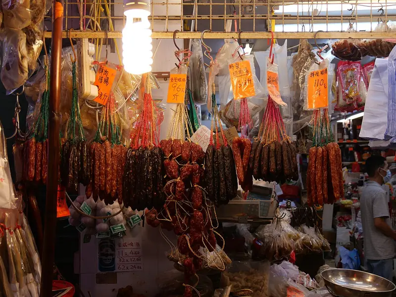 Daming Wubaiju Sausage 大名五百居香肠Reference photo of a similar dish · 同类菜品参考照片
Daming Wubaiju Sausage (大名五百居香肠) is a seasoned, air-dried and steamed sausage from Daming (大名). Its preparation uses a measured balance of lean and fatty meat, cut into small dice.
Source ↗Read the dish guide →
Photo adjustments
Full frame retained; EXIF orientation normalized, proportionally resized to at most 800 pixels and converted to WebP. No generated pixels or subject changes. Cards may crop the display.
Yongnian Donkey Meat Sausage 永年驴肉香肠Reference photo of a similar dish · 同类菜品参考照片
Yongnian Donkey Meat Sausage (永年驴肉香肠) is a smoked sausage of minced donkey meat from Linmingguan (临洺关), the seat of Yongnian District in Handan, Hebei.
Read the dish guide →Photo adjustments
Full frame retained; EXIF orientation normalized, proportionally resized to at most 800 pixels and converted to WebP. No generated pixels or subject changes. Cards may crop the display.
 Cixian Pangni Smoked Chicken 磁县胖妮熏鸡AI illustration · AI 示意图(仅供参考,非实拍)
Cixian Pangni Smoked Chicken (磁县胖妮熏鸡) is listed among the local specialties of Handan, Hebei. The name includes 鸡 (chicken). 熏 describes smoking.
Read the dish guide → Guo Ba Layered Flatbread 郭八火烧
Guo Ba Layered Flatbread (郭八火烧) is a thick, round griddle bread of many paper-thin layers from Daming County (大名县) in Handan (邯郸), Hebei.
Read the dish guide →Photo adjustments
EXIF orientation normalized; resized without changing aspect ratio; converted to WebP. No subject edits.
 Wu'an Hand-Pulled Noodles 武安拽面AI illustration · AI 示意图(仅供参考,非实拍)
Wu'an Hand-Pulled Noodles (武安拽面), zhuaimian in Chinese, are the pulled noodles of Wu'an (武安) in Handan (邯郸), Hebei.
Read the dish guide →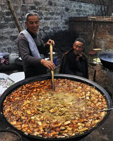 Weixian Big-Pot Stew 魏县大锅菜
Weixian Big-Pot Stew (魏县大锅菜), also called Weizhou big-pot stew (魏州大锅菜), is a one-pot dish of mixed vegetables and lean pork from Wei County (魏县) in Handan (邯郸).
Read the dish guide →Photo adjustments
EXIF orientation normalized; resized without changing aspect ratio; converted to WebP. No subject edits.
All dish names · 全部菜名 (10)
- Doumo Millet Porridge · 豆沫
- Daming Ermao Braised Chicken · 大名二毛烧鸡
- Daming Wubaiju Sausage · 大名五百居香肠
- Yongnian Donkey Meat Sausage · 永年驴肉香肠
- Cixian Pangni Smoked Chicken · 磁县胖妮熏鸡
- Guo Ba Layered Flatbread · 郭八火烧
- Wu'an Hand-Pulled Noodles · 武安拽面
- Weixian Big-Pot Stew · 魏县大锅菜
- Linzhang Braised Rabbit · 临漳扒兔
- Handan Soft-Bone Braised Fish · 邯郸酥鱼
More dishes from across Hebei are in the Hebei food guide.
Counties & districts in Handan
18 areas belong directly to Handan.
18 areas
Hanshan District邯山区
Hanshan is a district of the city of Handan, Hebei, People's Republic of China.
Explore the area →DistrictCongtai District丛台区
Congtai District (simplified Chinese: 丛台区; traditional Chinese: 叢台區; pinyin: Cóngtái Qū) is a district of the city of Handan, Hebei, China, with a population of 330,000 residing in an area of just 28 km² (11…
Explore the area →DistrictFuxing District复兴区
Fuxing District (simplified Chinese: 复兴区; traditional Chinese: 復興區; pinyin: Fùxīng Qū) is a district of the city of Handan, Hebei province, China, with a population of 250,000 residing in an area of 37 km²…
Explore the area →DistrictFengfeng Mining District峰峰矿区
Fengfeng Mining District (simplified Chinese: 峰峰矿区; traditional Chinese: 峰峰礦區; pinyin: Fēngfēng Kuàngqū) is a district of the city of Handan, Hebei, People's Republic of China.
Explore the area →Show fewer areas
Feixiang District肥乡区
Feixiang (simplified Chinese: 肥乡; traditional Chinese: 肥鄉; pinyin: Féixiāng) is a district of southern Hebei province, China, served directly by China National Highway 309.
Explore the area →DistrictYongnian District永年区
Yongnian is an urban district of the city of Handan, Hebei province, China. It is the seat of the Roman Catholic Diocese of Yongnian.
Explore the area →CountyLinzhang County临漳县
Linzhang County (simplified Chinese: 临漳县; traditional Chinese: 臨漳縣; pinyin: Línzhāng Xiàn) is a county of southmost Hebei province, China, named after the Zhang River within its borders.
Explore the area →CountyCheng'an County成安县
Cheng'an is a county of southern Hebei province, China. It is under the administration of Handan City, about 25 km (16 mi) to the northwest.
Explore the area →CountyDaming County大名县
Daming County is a county under the jurisdiction of Handan City in far southern Hebei Province, China. It was formerly one of the capitals of the Northern Song.
Explore the area →CountyShexian涉县
She County (simplified Chinese: 涉县; traditional Chinese: 涉縣; pinyin: Shè Xiàn), or Shexian, is a county of southwestern Hebei Province, China, located on the lower reaches of the Zhang River and bordering…
Explore the area →CountyCixian磁县
Ci County or Cixian (simplified Chinese: 磁县; traditional Chinese: 磁縣; pinyin: Cí Xiàn) is a county of Hebei, China. It is under the administration of Handan City.
Explore the area →CountyQiuxian邱县
Qiu County or Qiuxian (simplified Chinese: 邱县; traditional Chinese: 邱縣; pinyin: Qiū Xiàn) is a county in the south of Hebei province, China. It is under the administration of Handan City.
Explore the area →CountyJize County鸡泽县
Jize County (simplified Chinese: 鸡泽县; traditional Chinese: 雞澤縣; pinyin: Jīzé Xiàn) is a county of southern Hebei province, China.
Explore the area →CountyGuangping County广平县
Guangping County (simplified Chinese: 广平县; traditional Chinese: 廣平縣; pinyin: Guǎngpíng Xiàn; lit. 'broad flatness' is a county of southern Hebei province, China.
Explore the area →CountyGuantao County馆陶县
Guantao County (simplified Chinese: 馆陶县; traditional Chinese: 館陶縣; pinyin: Guǎntáo Xiàn) is a county of southern Hebei province, China, bordering Shandong's Guan County and Linqing to the east across the Wei…
Explore the area →CountyWeixian魏县
Wei County or Weixian (simplified Chinese: 魏县; traditional Chinese: 魏縣; pinyin: Wèi Xiàn) is a county in the south of Hebei province, China, bordering Henan province to the south.
Explore the area →CountyQuzhou County曲周县
Quzhou is a county under the administration of the prefecture-level city of Handan, in the south of Hebei Province, China. It means "where the river bends".
Explore the area →County-level cityWu'an武安市
Wu'an is a county-level city in the southwest of Hebei Province, China, bordering Shanxi Province to the west. It is under the administration of the prefecture-level city of Handan.
Explore the area →No areas match this name.
Plan your visit
Getting there
Search for 邯郸市 in a map app to find stations and your accommodation.
Where to stay →Build your route
Wahuang Palace and Guangfu Ancient City are about 100 km apart in a straight line. The linked place guides have entrance and visit details.
Continue with Hebei →More in Hebei
Sources & geographic information
Administrative names and parent areas: Official geographic directory · Reference date 2026-09-06.
Photo: Wahuang Palace · Anagoria · CC BY 3.0. Resized and WebP compressed; subject not altered.

Photo: Guangfu Ancient City · Xylener Nee · CC BY-SA 3.0. Proportionally resized and converted to WebP without cropping, retouching or changing the photographed subject.

Photo: Xiangtangshan Caves · H2v5o68z · CC0. Proportionally resized and converted to WebP without cropping, retouching or changing the photographed subject.

Photo: Handan Museum · H2v5o68z · CC0. Full-frame source proportionally resized and converted to WebP for display. No subject alteration. Source-supplied marks and edits remain; cards may crop the view.

Photo: Zhaowangcheng Ruins Park · H2v5o68z · CC0. Full frame retained; proportionally resized and converted to WebP. No retouching or changes to the photographed subject. Card displays may crop the view.

Photo: Congtai Park · H2v5o68z · CC0. Full frame retained; proportionally resized and converted to WebP. No retouching or changes to the photographed subject. Card displays may crop the view.

Photo: Daming Ancient City · 我乃野云鹤 · CC BY-SA 4.0. Full frame retained; proportionally resized and converted to WebP. No retouching or changes to the photographed subject. Card displays may crop the view.

Photo: East Taihang Scenic Area · H2v5o68z · CC0. Full frame retained; proportionally resized and converted to WebP. No retouching or changes to the photographed subject. Card displays may crop the view.

Photo: Qibugou Valley · 我乃野云鹤 · CC BY-SA 4.0. Full frame retained; proportionally resized and converted to WebP. No retouching or changes to the photographed subject. Card displays may crop the view.

Photo: Jingniang Lake · H2v5o68z · CC0. Full frame retained; proportionally resized and converted to WebP. No retouching or changes to the photographed subject. Card displays may crop the view.

Map data © OpenStreetMap contributors. Pins mark approximate centres, not entrances or boundaries.