


Get to know Sham Shui Po District

Photo adjustments
Full frame retained; proportionally resized and converted to WebP. No retouching or changes to the photographed subject. Card displays may crop the view.
- Administrative area
- District · 地區
- Part of
- Hong Kong
- Chinese name
- 深水埗
- Local areas
- District guide
Area & population
- Area in the source
- 9.48 km²
- Population · 2016
- 405,869
Source: cited geographic source, as of the dates shown.
Setting and areas
The Home Affairs Department sets the district's limits as the Lion Rock Country Park to the north, the East Rail line to the east, Boundary Street to the south and the waterfront, including Stonecutters Island (昂船洲), to the west. Within those lines it divides the district into seven areas: Central Sham Shui Po, Shek Kip Mei (石硤尾), Lai Chi Kok (荔枝角), the West Kowloon Reclamation, Mei Foo (美孚), Cheung Sha Wan (長沙灣) and the low-density Yau Yat Chuen (又一村).
History
Public housing in Hong Kong began here. After a fire in the district's squatter shanties in December 1953 left thousands homeless, the government built a resettlement estate on the burnt-out site; the district council records Shek Kip Mei Estate, from 1954, as Hong Kong's first public rental housing estate. Private housing has a local first too: Mei Foo Sun Chuen, built in 1968, is described by the council as Hong Kong's first large-scale private estate, with 99 blocks in eight phases. In the 1970s the district also held a camp for Vietnamese refugees.
What to see
The Lei Cheng Uk Han Tomb (李鄭屋漢墓) in Cheung Sha Wan is a cross-shaped brick tomb believed to date from the Eastern Han dynasty. It came to light by chance in August 1955, when the government was levelling a slope for resettlement blocks; visitors now view it through glass, and an exhibition hall opened in 1988, the year it became a declared monument. Mei Ho House (美荷樓), Block H of the 1950s Shek Kip Mei Estate, is the last single-block example of the Mark I design and reopened in 2013 as a youth hostel and heritage museum. In Lai Chi Kok, a former prison built between 1921 and 1924, later Lai Chi Kok Hospital, now houses the Jao Tsung-I Academy (饒宗頤文化館), with Chinese landscaped gardens and heritage galleries.
The district council notes wholesale and retail businesses in textiles, clothing, piece goods and non-staple food concentrated in Cheung Sha Wan and Lai Chi Kok, and describes the district as a distribution centre for computer and electronic goods, known for its computer shopping centres.
Highlights
- Mei Ho House 美荷楼生活馆: Surviving 1950s Mark I block of Shek Kip Mei Estate, reopened in 2013 as a youth hostel and heritage museum.
- Jao Tsung-I Academy 饶宗颐文化馆: Former prison and infectious-diseases hospital in Lai Chi Kok, with Chinese gardens and galleries.
- Lei Cheng Uk Han Tomb 李鄭屋漢墓: Eastern Han brick tomb found in 1955; declared a monument in 1988.
Sources for this guide
Home Affairs Department - Sham Shui Po District · Home Affairs Department, Hong Kong SAR Government
Sham Shui Po District Council - District Highlights · Sham Shui Po District Council, Hong Kong SAR Government
Sham Shui Po District · Wikipedia · CC BY-SA 4.0
Mei Ho House · Wikipedia · CC BY-SA 4.0
Lai Chi Kok Hospital · Wikipedia · CC BY-SA 4.0
Lei Cheng Uk Han Tomb Museum · Wikipedia · CC BY-SA 4.0
Original English written from the listed sources and checked sentence by sentence against quoted extracts by a separate reviewer. Updated 2026-09-25.
Explore Sham Shui Po District
Core places to explore, with English and Chinese names.
Places to explore around Sham Shui Po District
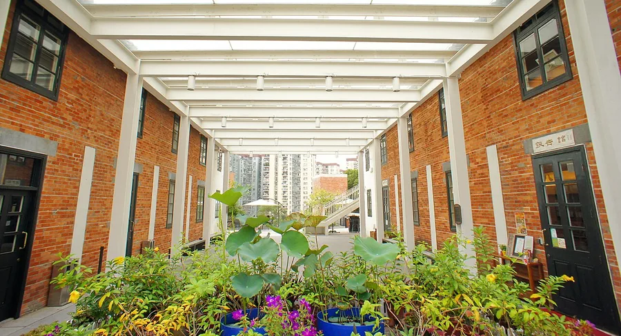 The Skylight Atrium in the Middle Zone of Jao Tsung-I Academy, Hong Kong. Photographed on 11 November 2014.
Jao Tsung-I Academy饶宗颐文化馆
Jao Tsung-I Academy reuses the former Lai Chi Kok Hospital as a cultural complex. Red-brick walls and pitched Chinese-tile roofs preserve the character of the historic buildings, which are grouped across three levels. The lower…
Read the place guide → Mei Ho House exterior in Shek Kip Mei · 石硖尾美荷楼外观 Photograph date recorded by the source: 24 May 2013, 11:11:26.
Mei Ho House美荷楼生活馆
Mei Ho House preserves an H-shaped early public-housing block, now adapted as a hostel and heritage museum. The exhibition uses residents’ oral histories, donated household objects and reconstructed units to show how living…
Read the place guide →A view across Sham Shui Po, photographed in 2009 · 深水埗 Photograph date recorded by the source: 14 March 2009.Sham Shui Po深水埗
Sham Shui Po is best explored through streets with different trading specialities. Apliu Street’s electronics and second-hand goods contrast with the cloth and sewing materials around Nam Cheong Street and Ki Lung Street. The…
Read the place guide →Local life & food
Sham Shui Po District local specialties
深水埗特色美食 · 1 specialties to discover
 Put chai ko cup puddings 砵仔糕AI dish illustration / AI 菜品示意图
The pudding has a springy, cohesive bite with soft beans. It differs from silky spoonable tofu pudding.
Source ↗Read the dish guide →All dish names · 全部菜名 (1)
More dishes from across Hong Kong are in the Hong Kong food guide.
Plan your visit
Getting there
Sham Shui Po District covers the centre of Hong Kong. Search for 深水埗 in a map app to find stations and your accommodation.
Where to stay →Build your route
Jao Tsung-I Academy and Mei Ho House are about 2 km apart in a straight line. The linked place guides have entrance and visit details.
Continue with Hong Kong →More in Hong Kong
Sources & geographic information
Administrative names and parent areas: Official geographic directory · Reference date 2026-09-06.
Some facts checked against Sham Shui Po District — Wikipedia contributors, CC BY-SA 4.0.
Some facts checked against Mei Ho House — Wikipedia contributors, CC BY-SA 4.0.
Some facts checked against Lai Chi Kok Hospital — Wikipedia contributors, CC BY-SA 4.0.
Some facts checked against Lei Cheng Uk Han Tomb Museum — Wikipedia contributors, CC BY-SA 4.0.
Photo: Jao Tsung-I Academy · Mk2010 · CC BY-SA 4.0. Proportionally resized and converted to WebP without cropping, retouching or changing the photographed subject.
.jpg)
Photo: Mei Ho House · Qwer132477 · Qwer132477 — Shek_Kip_Mei_Estate_2013_part6.JPG — CC BY-SA 3.0 · CC BY-SA 3.0. The exact downloaded source bytes are separately retained and hashed. Prepared JPEG is proportionally reduced to a maximum 720-pixel long edge; full frame retained, no subject alteration. Final website rendition: full frame retained, proportionally resized to at most 720 pixels and converted to WebP. No additional retouching or subject alteration. Card displays may crop the view.

Photo: Sham Shui Po · WiNG · CC BY-SA 3.0. Full frame retained; proportionally resized and converted to WebP. No retouching or changes to the photographed subject. Card displays may crop the view.

Map data © OpenStreetMap contributors. Pins mark approximate centres, not entrances or boundaries.