


Get to know Wujiang District
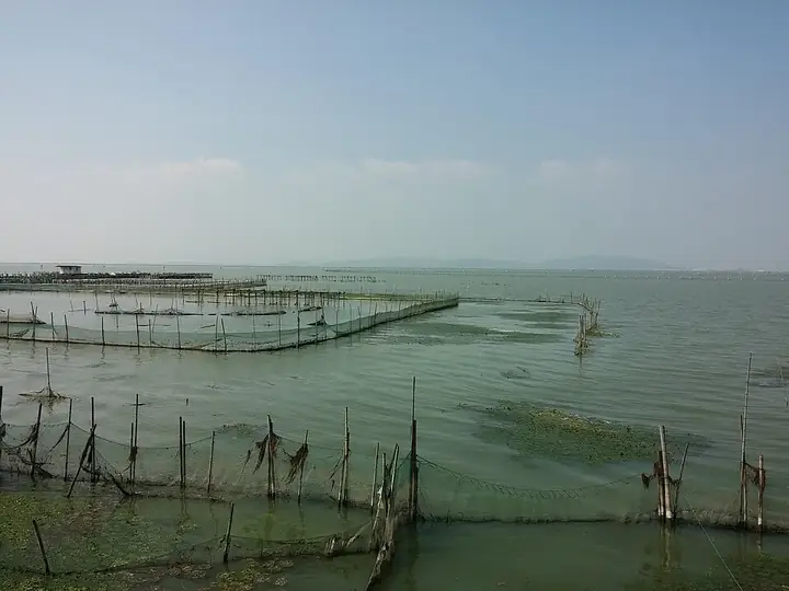
Photo adjustments
Full frame retained; resized proportionally to a maximum dimension of 960 pixels and converted to WebP quality 88. No crop, retouch, generated elements, or subject alteration. Final website rendition: full frame retained, proportionally resized to at most 720 pixels and converted to WebP. No additional retouching or subject alteration. Card displays may crop the view.
- Administrative area
- District · 市辖区
- Part of
- Suzhou
- Chinese name
- 吴江区
- Local areas
- District guide
Area & population
- Area in the source
- 1,176.68 km²
- Population · 2020 census
- 1,545,023
Source: cited geographic source, as of the dates shown.
Setting and landscape
Water covers 314.44 square kilometres of the district, a water ratio of 25.41 per cent. The district counts 330 lakes on Jiangsu's lake-protection list, Lake Tai among them, and 2,663 rivers and canals. Its Lake Tai frontage forms the East Lake Tai resort area, a national tourist resort where Lake Tai, the Grand Canal and the Taipu River (太浦河) meet. The Wujiang system of fish-pond farming and silkworm culture is on China's third preparatory list for globally important agricultural heritage.
History and heritage
Wujiang has two World Heritage components, the Tuisi Garden (退思园) in Tongli, part of the Classical Gardens of Suzhou, and the ancient canal towpath (运河古纤道) on the Grand Canal, along with ten national key cultural relics protection units. The district government names silk, water towns, the canal and the poetry of water shield and perch (莼鲈) among its cultural themes, and counts Fan Li (范蠡), the Tang writer Lu Guimeng (陆龟蒙), the poet Liu Yazi (柳亚子) and the sociologist Fei Xiaotong (费孝通) among its notable people.
What to see
Tongli, in the east of the district 18 kilometres south of Suzhou, became a town in the Song, is a national 5A scenic area and still has its original residents; the district government notes that the Tuisi Garden makes it the only Jiangnan water town containing a World Heritage site. Lili took shape in the Southern Song and keeps close to 100,000 square metres of Ming, Qing and Republican-era buildings in a core zone of 0.69 square kilometres, noted for its lanes, bridges and river banks. Zhenze, whose name is an old name for Lake Tai, became a town under the Southern Song and is described by the district government as the country's only national 4A scenic area built around silk.
At Pingwang (平望), a 4A canal scenic area sits where four waterways meet, with the Ande Bridge (安德桥), Siqian Street (司前街) and Yingdou Lake (莺脰湖) along the old canal. Kaixiangong village (开弦弓村) in Qidu (七都), on the southeast shore of Lake Tai, is the "Jiangcun" that Fei Xiaotong visited 26 times; it became a window on rural China for scholars at home and abroad. The Jingsi Garden (静思园), begun in 1993, holds a large collection of ornamental stones.
Getting oriented
The Shanghai–Suzhou–Huzhou high-speed railway runs through the district, with stations at Suzhou South and Shengze (盛泽). Suzhou Metro Line 4 has 13 stations in Wujiang.
Highlights
- Tongli 同里古镇: Song-dynasty water town and 5A scenic area; home of the World Heritage Tuisi Garden.
- Lili 黎里古镇: Southern Song water town with close to 100,000 square metres of old buildings; a national historic town since 2014.
- Zhenze 震泽古镇: Water town named after Lake Tai's old name, with a scenic area built around silk.
- Kaixiangong village 开弦弓村: Fei Xiaotong's 'Jiangcun', visited by him 26 times.
- Pingwang canal scenic area 吴江运河文化旅游景区: 4A site where four waterways meet on the Grand Canal.
Sources for this guide
地理位置_苏州市吴江区人民政府 · Wujiang District People's Government, Suzhou
自然条件_苏州市吴江区人民政府 · Wujiang District People's Government, Suzhou
人文历史_苏州市吴江区人民政府 · Wujiang District People's Government, Suzhou
旅游资源_苏州市吴江区人民政府 · Wujiang District People's Government, Suzhou
Original English written from the listed sources and checked sentence by sentence against quoted extracts by a separate reviewer. Updated 2026-09-25.
Explore Wujiang District
Core places to explore, with English and Chinese names.
Places to explore around Wujiang District
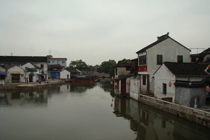 Canalside houses and a stone bridge in Tongli Ancient Town, Wujiang District · 同里古镇河道与石桥,苏州市吴江区 Source-recorded photograph date: Taken on 6 September 2008.
Tongli Ancient Town同里古镇
Tongli in Wujiang is a water town where riverside houses, stone bridges and courtyard gardens form a closely connected historic landscape.
Read the place guide → The memorial archway marking the entrance to Zhenze Old Town, Wujiang · 苏州市吴江区震泽古镇牌坊 Source-recorded photograph date: 2026-03-07 10:42:28.
Zhenze Ancient Town震泽古镇
Zhenze in Wujiang grew beside the Ditang River, linking silk production with a townscape of bridges, a pagoda and courtyard houses.
Read the place guide → The canal at Lili Old Town, Wujiang, with a pavilion bridge in the distance · 苏州市吴江区黎里古镇河道,远处可见廊桥 Source-recorded photograph date: 2026-03-07 11:22:06.
Lili Ancient Town黎里古镇
Lili's old town in Wujiang is organized around a T-shaped waterway, with riverside streets leading into the lanes of historic family compounds.
Read the place guide →Plan your visit
Getting there
Wujiang District is about 20 km in a straight line from central Suzhou. Search for 吴江区 in a map app to find stations and your accommodation.
Where to stay →Build your route
Tongli Ancient Town and Zhenze Ancient Town are both listed here. The linked place guides have entrance and visit details.
Continue with Suzhou →More in Suzhou
Sources & geographic information
Administrative names and parent areas: Official geographic directory · Reference date 2026-09-06.
Photo: Tongli Ancient Town · 山海风 · CC BY-SA 3.0. Full frame retained; proportionally resized and converted to WebP. No retouching or changes to the photographed subject. Card displays may crop the view.
.jpg)
Photo: Zhenze Ancient Town · Siyuwj · CC BY-SA 4.0. Full frame retained; proportionally resized and converted to WebP. No retouching or changes to the photographed subject. Card displays may crop the view.

Photo: Lili Ancient Town · Siyuwj · CC BY-SA 4.0. Full frame retained; proportionally resized and converted to WebP. No retouching or changes to the photographed subject. Card displays may crop the view.

Map data © OpenStreetMap contributors. Pins mark approximate centres, not entrances or boundaries.