


Get to know Hunyuan County
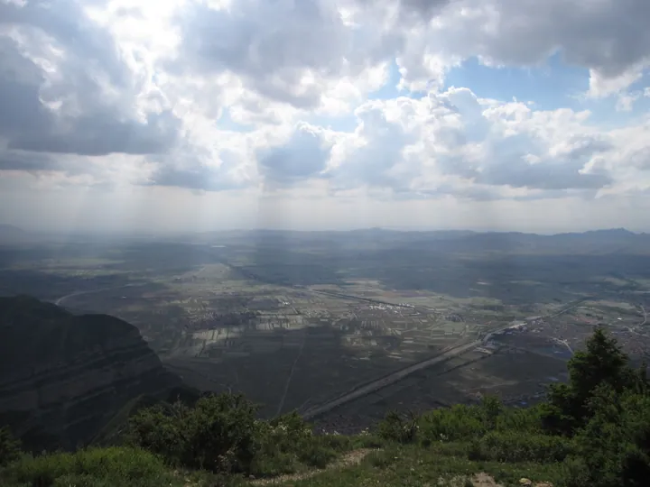
Photo adjustments
Full frame retained; proportionally resized and converted to WebP. No retouching or changes to the photographed subject. Card displays may crop the view.
- Administrative area
- County · 县
- Part of
- Datong
- Chinese name
- 浑源县
- Local areas
- County guide
Area & population
- Area in the source
- 1,965.00 km²
- Population · 2020
- 237,749
Source: cited geographic source, as of the dates shown.
Setting and landscape
The county sits on the edge of the Loess Plateau, with mountains in the south, slopes in the north and a river plain between them. The Heng range runs from northeast to southwest; the highest point is Woyangchang Mountain (卧羊场山) at 2,333 metres and the lowest the bed of the Hun River (浑河) at 1,050 metres. The Hun, a tributary of the Sanggan (桑干河) on the upper Yongding, flows 62 km through the county, and the Tang River (唐河), a southern tributary of the Daqing (大清河), runs 31 km through it. The Tangtou hot spring (汤头温泉) emerges at 63 °C.
History
Under the Western Han the area was called Guo County (崞县), and the name Hunyuan was fixed under the Tang. In 1267 it was merged into Hunyuan Prefecture (浑源州) under Datong Circuit, becoming Hunyuan County again in May 1912. Before the Ming, the name Mount Heng meant Damao Mountain (大茂山) in Hebei; in the Shunzhi reign of the Qing the state sacrifice to the Northern Peak moved to Xuanyue Mountain (玄岳山) in Hunyuan, which then took the name Hengshan.
The walled town was moved to its present site under the Later Tang and became a provincial historic and cultural city in 1993. Its octagonal, turtle-shaped plan runs along Yong'an West Street (永安西街), with lanes branching off like fishbones, and it keeps 154 old houses.
What to see
Mount Heng became one of China's first national scenic areas in 1982. Its main peak, Tianfeng Ling (天峰岭), rises to 2,016.1 metres, and the mountain is counted as the fifth of Daoism's 36 grotto-heavens.
The Hanging Temple lies between the county town and Mount Heng, about three kilometres from the mountain gate, in a hollow halfway up Cuiping Mountain (翠屏山). Founded under the Northern Wei, with buildings now mostly Ming and Qing, its 40 wooden rooms rest on 27 beams; its highest point is over 90 metres above the valley floor. The Three Teachings Hall (三教殿) enshrines Shakyamuni, Confucius and Laozi. It became a national key site in 1982.
Six more national key sites stand in the county: Yong'an Temple (永安寺), Dayun Temple (大云寺), Yuanjue Temple (圆觉寺), the Lülü Shrine (律吕神祠), the Confucian temple (文庙) and the tomb of the Qing river official Li Yumei (栗毓美). Shenxi National Wetland Park (神溪国家湿地公园) covers 316 hectares and contains the Lülü Shrine and Shenxi village (神溪村), a listed traditional village.
Local products
Hengshan astragalus (恒山黄芪) is a Chinese geographical indication product.
Highlights
- Mount Heng 恒山: The Northern Peak since the Qing; main peak Tianfeng Ling, 2,016.1 m; national scenic area since 1982.
- Hanging Temple 悬空寺: Northern Wei foundation on a cliff of Cuiping Mountain, held up by 27 wooden beams; national key site since 1982.
- Hunyuan old town 浑源古城: Octagonal walled town on Yong'an West Street; provincial historic and cultural city since 1993.
- Shenxi National Wetland Park 神溪国家湿地公园: 316-hectare wetland park containing the Lülü Shrine and Shenxi village.
- Hengshan astragalus 恒山黄芪: Chinese geographical indication product.
Sources for this guide
自然地理 - 浑源概况 - 浑源县人民政府 · Hunyuan County People's Government
人文历史 - 浑源概况 - 浑源县人民政府 · Hunyuan County People's Government
景点景区 - 浑源概况 - 浑源县人民政府 · Hunyuan County People's Government
浑源古城 - 旅游观光 - 浑源县人民政府 · Hunyuan County People's Government
浑源县 - 维基百科,自由的百科全书 · Wikipedia (Chinese) · CC BY-SA 4.0
悬空寺 - 维基百科,自由的百科全书 · Wikipedia (Chinese) · CC BY-SA 4.0
恒山 - 维基百科,自由的百科全书 · Wikipedia (Chinese) · CC BY-SA 4.0
Original English written from the listed sources and checked sentence by sentence against quoted extracts by a separate reviewer. Updated 2026-09-23.
Explore Hunyuan County
Core places to explore, with English and Chinese names.
Places to explore around Hunyuan County
 Mount Heng(Hengshan), is a mountain in north-central China's Shanxi Province, known as the northern mountain of the Five Great Mountains of China.
Mount Heng (Shanxi)恒山
Northern Hengshan rises south of Hunyuan, with Tianfengling Peak above a group of mountain temples. Its religious buildings exploit the steep slopes and cliff recesses, so the approach and changes in level are part of their…
Read the place guide →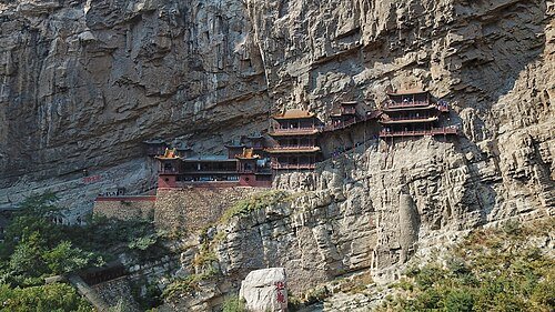 Hengshan Hanging Temple (Xuankong si) · 悬空寺
Hanging Temple悬空寺
The Hanging Temple uses beams inserted into the cliff to support a narrow chain of rooms and galleries above the valley. Its standing buildings largely reflect Ming and Qing rebuilding, despite the much older foundation story…
Read the place guide →Plan your visit
Getting there
Hunyuan County is about 55 km in a straight line from central Datong. Search for 浑源县 in a map app to find stations and your accommodation.
Where to stay →Build your route
Mount Heng (Shanxi) and Hanging Temple are about 3 km apart in a straight line. The linked place guides have entrance and visit details.
Continue with Datong →More in Datong
Sources & geographic information
Administrative names and parent areas: Official geographic directory · Reference date 2026-09-06.
Some facts checked against 浑源县 — Wikipedia contributors, CC BY-SA 4.0.
Some facts checked against 悬空寺 — Wikipedia contributors, CC BY-SA 4.0.
Some facts checked against 恒山 — Wikipedia contributors, CC BY-SA 4.0.
Photo: Mount Heng (Shanxi) · Charlie fong · CC BY-SA 4.0. Resized and WebP compressed; subject not altered.

Photo: Hanging Temple · Charlie fong · CC BY-SA 4.0. Wikimedia thumbnail; fitted to the ranking-card frame.

Map data © OpenStreetMap contributors. Pins mark approximate centres, not entrances or boundaries.