


Get to know Ürümqi County
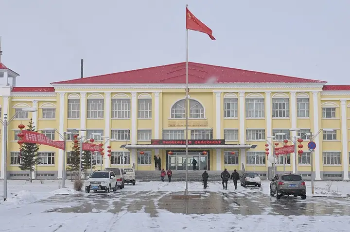
Photo adjustments
Full frame retained; resized proportionally to a maximum dimension of 960 pixels and converted to WebP quality 88. No crop, retouch, generated elements, or subject alteration. Final website rendition: full frame retained, proportionally resized to at most 720 pixels and converted to WebP. No additional retouching or subject alteration. Card displays may crop the view.
- Administrative area
- County · 县
- Part of
- Ürümqi
- Chinese name
- 乌鲁木齐县
- Local areas
- County guide
Area & population
- Population · 2020
- 73,590
- Administrative seat
- Banfanggou
Source: cited geographic source, as of the dates shown.
Setting and landscape
Mountains close the county in on the east, south and west, while the north and centre are open and flat; farms and towns sit on the plain, with forest and herding land in the mountains. To the south, the Tugetage Pass (吐格塔格达坂) on the Tianshan marks the boundary with Toksun (托克逊) and Hejing (和静) counties. The Ürümqi River (乌鲁木齐河), the Toutun River (头屯河) and the Baiyang River (白杨河) are fed mainly by glacier and snow melt. Snow leopards, Siberian ibex, black storks and great bustards are among the protected animals, and snow lotus, fritillary and liquorice grow wild.
History
In the Ming and early Qing the area belonged first to the Khoshut (和硕特部), one of the four Oirat Mongol tribes, and then to the Dzungars (准噶尔部). The county government dates the county to Dihua County (迪化县), set up in 1886. In October 1945 the town and its surroundings were split off as Dihua City, and in February 1954 the county took the name Ürümqi County. The county seat is at Banfanggou (板房沟镇).
What to see
The Tianshan Grand Canyon (天山大峡谷), about 48 kilometres from central Ürümqi, is a national forest park and a national 5A scenic area covering 1,038.48 square kilometres on the northern side of the Karawuchen Mountains (喀拉乌成山), between Bogda Peak (博格达峰) and Tianger Peak (天格尔峰). It holds the most complete old-growth Schrenk spruce (雪岭云杉) forest on the northern Tianshan, and the Kazakh herders who live there have earned it the name "museum of nomadic culture". Sights include Zhaobi Mountain (照壁山), a roughly 400-metre pyramid of rock with water on three sides, Swan Lake (天鹅湖) at 2,449 metres, and the Qiaoya grassland (乔亚草场) above 2,500 metres.
Within the forest park's planning area are the Miao'ergou waterfall (庙儿沟瀑布), the Silk Road ski resort (丝绸之路滑雪场) and other ski slopes on the Pingxi ridge (平西梁子), plus the East Baiyang Gully (东白杨沟) and Muxutaizi (苜蓿台子) scenic areas.
Getting oriented
The Lianyungang-Khorgas Expressway (连霍高速) and National Highway 216 pass through the county; G216 also forms the western edge of the Tianshan Grand Canyon area.
Highlights
- Tianshan Grand Canyon 天山大峡谷: National forest park and national 5A scenic area with old-growth Schrenk spruce forest.
- Zhaobi Mountain 照壁山: A pyramid-shaped peak about 400 m high, surrounded by water on three sides.
- Swan Lake 天鹅湖: A lake in alpine meadow at 2,449 m where swans stay in summer and autumn.
- Silk Road ski resort 丝绸之路滑雪场: One of four ski areas on the Pingxi ridge within the forest park.
Sources for this guide
乌县概况 - 乌鲁木齐县人民政府 · Ürümqi County People's Government
乌鲁木齐县 - 维基百科,自由的百科全书 · Wikipedia · CC BY-SA 4.0
天山大峡谷 - 维基百科,自由的百科全书 · Wikipedia · CC BY-SA 4.0
Original English written from the listed sources and checked sentence by sentence against quoted extracts by a separate reviewer. Updated 2026-09-25.
Explore Ürümqi County
Core places to explore, with English and Chinese names.
Places to explore around Ürümqi County
 AI illustration · AI 示意图(仅供参考,非该地点实拍)
Urumqi Tianshan Grand Canyon乌鲁木齐天山大峡谷
Urumqi Tianshan Grand Canyon is a mountain destination in Urumqi County, with forest, rock scenery and valley views.
Read the place guide → Nanshan West Baiyanggou Valley · 南山西白杨沟
Nanshan West Baiyanggou Valley南山西白杨沟
West Baiyanggou (西白杨沟) is one of the valleys of the Nanshan, or South Mountain, scenic area in Urumqi County (乌鲁木齐县), Xinjiang. The municipal register enters it as 西白杨沟(南山牧场), a 3A-grade scenic area at Baiyanggou village in Gangou Township (甘沟乡).
Read the place guide → Tianshan Grand Canyon (天山大峡谷), Ürümqi County. Photograph: "照壁山庄 - panoramio".
Tianshan Grand Canyon天山大峡谷
Spruce-forested Tianshan valleys 40 km from Ürümqi, with the pyramid-shaped Zhaobishan, Swan Lake and Kazakh summer pastures.
Read the place guide → AI illustration · AI 示意图(仅供参考,非该地点实拍)
Silk Road Mountain Resort丝绸之路山地度假区
The Silk Road Mountain Resort (丝绸之路山地度假区) is a ski and holiday resort at Pingxiliang in Shuixigou Township (水西沟镇), Urumqi County (乌鲁木齐县), Xinjiang, in the Nanshan area. The regional culture and tourism department rates its ski area SSSSS and the municipal register lists the resort as a 4A-grade scenic area.
Read the place guide →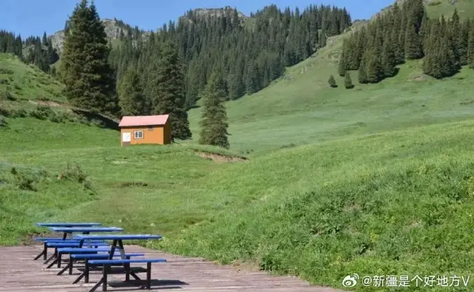 Muxutai Ecological Park · 苜蓿台
Muxutai Ecological Park苜蓿台
Muxutai (苜蓿台), entered by the municipal register as Muxutai Ecological Park (苜蓿台生态公园), is a tourism area on a summit grassland platform in Tuoli Township (托里乡), Urumqi County (乌鲁木齐县), Xinjiang, 55 km from Urumqi at 2,020 m elevation.
Read the place guide →Plan your visit
Getting there
Ürümqi County is about 40 km in a straight line from central Ürümqi. Search for 乌鲁木齐县 in a map app to find stations and your accommodation.
Where to stay →Build your route
Urumqi Tianshan Grand Canyon and Nanshan West Baiyanggou Valley are both listed here. The linked place guides have entrance and visit details.
Continue with Ürümqi →More in Ürümqi
Sources & geographic information
Administrative names and parent areas: Official geographic directory · Reference date 2026-09-06.
Some facts checked against 乌鲁木齐县 — Wikipedia contributors, CC BY-SA 4.0.
Some facts checked against 天山大峡谷 — Wikipedia contributors, CC BY-SA 4.0.
Photo: Nanshan West Baiyanggou Valley · Source photographer · License not provided. EXIF orientation normalized; resized without changing aspect ratio; converted to WebP. No subject edits.
Photo: Tianshan Grand Canyon · 陈琛 · CC BY-SA 3.0. Full frame retained; EXIF orientation normalized, proportionally resized to at most 800 pixels and converted to WebP. No generated pixels or subject changes. Cards may crop the display.

Photo: Muxutai Ecological Park · Source photographer · License not provided. EXIF orientation normalized; resized without changing aspect ratio; converted to WebP. No subject edits.
Map data © OpenStreetMap contributors. Pins mark approximate centres, not entrances or boundaries.