


Get to know Fengze District
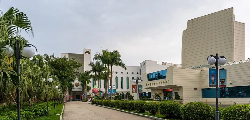
Photo adjustments
Full frame retained; proportionally resized and converted to WebP. No retouching or changes to the photographed subject. Card displays may crop the view.
- Administrative area
- District · 市辖区
- Part of
- Quanzhou
- Chinese name
- 丰泽区
- Local areas
- District guide
Area & population
- Area in the source
- 126.50 km²
- Population · 2020
- 698,557
Source: cited geographic source, as of the dates shown.
Setting and landscape
The district reaches from Dayang Mountain (大阳山) in the north to the mouth of the Jin River in the south, and faces Quanzhou Bay (泉州湾) and the Taiwan Strait to the southeast. Across the Luoyang River lies Hui'an (惠安县); Licheng District (鲤城区) and Nan'an (南安市) adjoin it to the west, Jinjiang (晋江市) lies across the Jin River to the south, and Luojiang District (洛江区) to the north. It covers about 130 square kilometres, with 21 kilometres of coastline.
History
Fengze was created in June 1997, when the State Council split it off from Licheng with four subdistricts, three towns and the Qingyuan farm. The name comes from the Fengze sluice gate (丰泽斗门), a Song-dynasty water-control work in the area. From 718 most of the ground lay in Jinjiang County, with a western strip in Nan'an; from 1985 it was all in Licheng District.
What to see
Qingyuan Mountain (清源山), 615 metres high, gives its name to a 5A-rated national scenic area of 62 square kilometres in three sections: Qingyuan Mountain, Jiuri Mountain (九日山) and Lingshan (灵山). It holds more than 600 cliff inscriptions and large Tang-to-Yuan stone figures, among them Laojun Rock (老君岩), described by the district government as the largest surviving Song-dynasty Taoist stone statue in China. Its Islamic holy tombs (伊斯兰教圣墓) are the graves of two companions of the Prophet who sailed from Arabia to Quanzhou in the 7th century.
On the south slope of Wansui Hill (万岁山) at Fashi (法石), the Zhenwu Temple (真武庙) faces west, with a view southwest over the lower Jin River. Its main hall dates from the Song and was rebuilt in the Qing, and in 2021 it was one of 22 Quanzhou sites inscribed on UNESCO's World Heritage List. The district government names Houzhu port (后渚港) as the eastern starting point of the ancient maritime Silk Road.
Local customs
The Xunpu women's customs (蟳埔女习俗) of Xunpu (蟳埔), Jinqi (金崎) and other communities in Donghai subdistrict (东海街道) have been national intangible heritage since 2008. Women wear a flower headdress called zanhuawei (簪花围) and the houses are built with large oyster shells (蚵壳厝) that, according to the national heritage list, were carried back by ocean-going ships in the Song and Yuan dynasties.
Getting oriented
Quanzhou station on the Fuzhou–Xiamen railway is in the district, and Chinese Wikipedia describes Fengze as the district with the most universities in Quanzhou, among them Huaqiao University (华侨大学) and Quanzhou Normal University (泉州师范学院).
Highlights
- Qingyuan Mountain 清源山: 62-square-kilometre scenic area with Laojun Rock and more than 600 cliff inscriptions.
- Fashi Zhenwu Temple 真武庙: Temple whose main hall was founded in the Song, looking over the lower Jin River; part of the Quanzhou World Heritage inscription of 2021.
- Xunpu village 蟳埔: Community known for flower headdresses and oyster-shell houses; national intangible heritage since 2008.
- Houzhu port 后渚港: Named by the district government as the eastern starting point of the ancient maritime Silk Road.
Sources for this guide
丰泽概况-走进丰泽-泉州市丰泽区人民政府 · Fengze District People's Government, Quanzhou
历史沿革-走进丰泽-泉州市丰泽区人民政府 · Fengze District People's Government, Quanzhou
泉州法石真武庙 · Fengze District People's Government, Quanzhou
清源山风景名胜区(AAAAA) · Fengze District People's Government, Quanzhou
丰泽区 - 维基百科 · Wikipedia (Chinese) · CC BY-SA 4.0
蟳埔女习俗 - 中国非物质文化遗产网·中国非物质文化遗产数字博物馆 · China Intangible Cultural Heritage Network (China National Centre for the Safeguarding of Intangible Cultural Heritage)
Original English written from the listed sources and checked sentence by sentence against quoted extracts by a separate reviewer. Updated 2026-09-25.
Explore Fengze District
Core places to explore, with English and Chinese names.
Places to explore around Fengze District
Entrance of Quanzhou Maritime Museum · 泉州海外交通史博物馆 Photograph date recorded by the source: 4 April 2023, 17:01:47.Quanzhou Maritime Museum泉州海外交通史博物馆
Quanzhou Maritime Museum tells the port’s overseas story through ship models, nautical material and religious stone carving. Tombstones and architectural fragments bearing Islamic, Christian and Hindu imagery are especially…
Read the place guide → The carved Amitabha Buddha at Mituoyan, a nationally protected relic on Mount Qingyuan, Quanzhou · 泉州清源山弥陀岩石刻佛像(全国重点文物保护单位) Source-recorded photograph date: 2012-03-01 11:02:30.
Mount Qingyuan清源山
Qingyuan Mountain’s best-known landmark is the large seated Laozi carved from stone near the main entrance. Above it, paved paths and steps climb through woodland towards religious monuments and views of Quanzhou. The lake and…
Read the place guide → AI illustration · AI 示意图(仅供参考,非该地点实拍)
Xunpu Village蟳埔村
Xunpu is a fishing village at the Jinjiang estuary in Quanzhou's Fengze District, known for flower-ring headdresses and houses faced with oyster shells.
Read the place guide →Plan your visit
Getting there
Fengze District is about 5 km in a straight line from central Quanzhou. Search for 丰泽区 in a map app to find stations and your accommodation.
Where to stay →Build your route
Quanzhou Maritime Museum and Mount Qingyuan are about 5 km apart in a straight line. The linked place guides have entrance and visit details.
Continue with Quanzhou →More in Quanzhou
Sources & geographic information
Administrative names and parent areas: Official geographic directory · Reference date 2026-09-06.
Some facts checked against 丰泽区 — Wikipedia contributors, CC BY-SA 4.0.
Photo: Quanzhou Maritime Museum · Iswzo · CC BY-SA 4.0. Full frame retained; proportionally resized and converted to WebP. No retouching or changes to the photographed subject. Card displays may crop the view.

Photo: Mount Qingyuan · Zhangzhugang · CC BY-SA 4.0. Full frame retained; proportionally resized and converted to WebP. No retouching or changes to the photographed subject. Card displays may crop the view.

Map data © OpenStreetMap contributors. Pins mark approximate centres, not entrances or boundaries.