


Get to know Jonê County
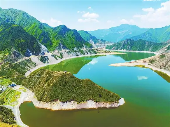
Photo adjustments
EXIF orientation normalized; resized without changing aspect ratio; converted to WebP. No subject edits.
- Administrative area
- County · 县
- Part of
- Gannan Tibetan Autonomous Prefecture
- Chinese name
- 卓尼县
- Local areas
- County guide
Area & population
- Population · 2020
- 95,387
- Administrative seat
- Liulin
Source: cited geographic source, as of the dates shown.
Setting and landscape
The county sits where the Yangtze and Yellow River basins meet, and the county government calls it a meeting zone of farming and herding ways of life. Rivers large and small spread out from the Tao across the whole county, and forest land covers about 3.34 million mu, most of it managed by the Tao River national nature reserve and ecological centres. The forests yield more than 100 kinds of fungi and ferns, including morels, and wildlife such as black bears, musk deer and bearded vultures.
History and monasteries
According to a county-government article, the Yang family received the chieftaincy in 1418, the 16th year of the Yongle reign, and ruled by inheritance from then on. Yang Jiqing (杨积庆), the 19th chieftain, is remembered for opening the granaries to support the Red Army.
Chanding Monastery (禅定寺), in Tibetan Jonê Tenzin Dargye Ling, stands on a terrace about half a kilometre northwest of the county seat. The Gannan prefecture government says it was sited and founded in 1295 by the Sakya leader Phagpa (八思巴) and describes it as the oldest Tibetan Buddhist monastery in Amdo. Monasteries such as Kangduo (康多寺, 1676) and Shaowa (杓哇寺, 1685) were later placed under it as two of its 108 branch monasteries.
What to see and eat
Dayugou (大峪沟) is the county's national 4A scenic area. Inside it are Qibu Monastery (旗布寺), the narrow gorge called Yixiantian (一线天, "one line of sky") with a stream along the path, and Sanjiaoshi (三角石), a lookout reached by a climbing trail. Highway G248, which the county promotes as a self-drive route, crosses the county.
Taoyan inkstones (洮砚) come from Taoyan township (洮砚乡). The chieftain banquet (土司宴), once served to guests of the chieftain's household, now features morels, Tibetan hotpot, Tibetan steamed buns, rice with silverweed root (蕨麻米饭) and yak yoghurt.
Highlights
- Chanding Monastery 禅定寺: Founded in 1295 under Phagpa; described by the prefecture as the oldest Tibetan Buddhist monastery in Amdo.
- Dayugou 大峪沟: National 4A scenic area with Qibu Monastery, the Yixiantian gorge and the Sanjiaoshi lookout.
- Taoyan inkstone 洮砚: Inkstone made from stone quarried in Taoyan township.
- Chieftain banquet 土司宴: Former household banquet of the Yang chieftains, with morels, Tibetan hotpot and yak yoghurt.
Sources for this guide
卓尼县基本县情(2025年)-卓尼县人民政府 · Jonê County People's Government
卓尼自然地理-卓尼县人民政府 · Jonê County People's Government
卓尼县寺院简介-甘南藏族自治州人民政府 · Gannan Tibetan Autonomous Prefecture People's Government
卓尼大峪沟:一场不可错过的梦幻之旅-卓尼县人民政府 · Jonê County People's Government
卓尼土司宴:五百年风华,一席家国情-卓尼县人民政府 · Jonê County People's Government
卓尼县 - 维基百科,自由的百科全书 · Wikipedia · CC BY-SA 4.0
Original English written from the listed sources and checked sentence by sentence against quoted extracts by a separate reviewer. Updated 2026-09-23.
Explore Jonê County
Core places to explore, with English and Chinese names.
Places to explore around Jonê County
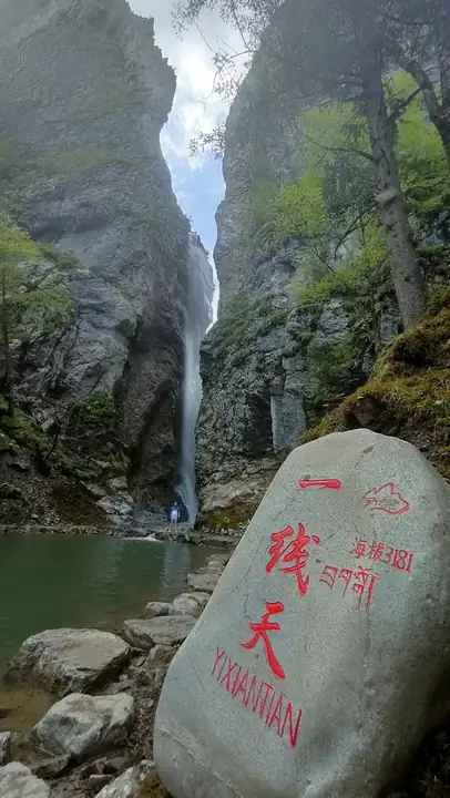 Dayugou Scenic Area · 大峪沟
Dayugou Scenic Area大峪沟
Dayugou (大峪沟) is a national AAAA-grade scenic area in Muer township, Zhuoni county, Gannan Tibetan Autonomous Prefecture, Gansu, comprising nine fan-shaped tributary gullies of the Dayugou, a Taohe river tributary that runs north to south through the area.
Read the place guide → AI illustration · AI 示意图(仅供参考,非该地点实拍)
Chanding Monastery禅定寺
Chanding Temple (禅定寺), also known as the Zhuoni Temple, is a Tibetan Buddhist monastery in the county town of Zhuoni, Gannan Tibetan Autonomous Prefecture, Gansu, which took its present name from a grant by the Kangxi emperor in 1710.
Read the place guide →Plan your visit
Getting there
Jonê County is about 70 km in a straight line from central Gannan Tibetan Autonomous Prefecture. Search for 卓尼县 in a map app to find stations and your accommodation.
Where to stay →Build your route
Dayugou Scenic Area and Chanding Monastery are both listed here. The linked place guides have entrance and visit details.
Continue with Gannan Tibetan Autonomous Prefecture →More in Gannan Tibetan Autonomous Prefecture
Sources & geographic information
Administrative names and parent areas: Official geographic directory · Reference date 2026-09-06.
Some facts checked against 卓尼县 — Wikipedia contributors, CC BY-SA 4.0.
Photo: Dayugou Scenic Area · Source photographer · License not provided. EXIF orientation normalized; resized without changing aspect ratio; converted to WebP. No subject edits.
Map data © OpenStreetMap contributors. Pins mark approximate centres, not entrances or boundaries.