


Get to know Lintan County

- Administrative area
- County · 县
- Part of
- Gannan Tibetan Autonomous Prefecture
- Chinese name
- 临潭县
- Local areas
- County guide
Area & population
- Area in the source
- 1,557.68 km²
- Population · 2020
- 127,387
- Administrative seat
- Chengguan (Zhacêr)
Source: cited geographic source, as of the dates shown.
Setting and landscape
The county is mostly high hill country, higher in the west than the east, at 2,209 to 3,926 metres with an average of 2,825 metres. The Tao River (洮河), the Yemu River (冶木河) and the Yangsha River (羊沙河) cross it, and the county government classes its climate as cold and dry highland. Around Yeliguan (冶力关), the land climbs from 2,219 metres on the Yemu River to 3,926 metres on Baishi Mountain (白石山) within a short distance.
History
Lintan's old name is Taozhou (洮州). In 631, under the Tang, Meixiang County was renamed Lintan, "beside the pool": the old geography Yuanhe Junxian Zhi (元和郡县志) records that the Tao River wrapped the town on three sides, as if it stood beside a pool. The Tang generals Li Sheng (李晟) and his son Li Su (李愬) came from here. Taozhou was a Ming guard (洮州卫) and a Qing subprefecture, became Lintan County in 1913 and joined Gannan in 1953. The county seat moved to present-day Chengguan town (城关镇) in 1952.
What to see
The Taozhou Guard City (洮州卫城) in Xincheng town (新城镇) was rebuilt from an older town as the Taozhou Guard seat after a 1379 revolt. Facing south with a river along its southern side and hills on the other three, its walls run for 5,430 metres; of its old gates only the southern Yingxun Gate (迎薰门) survives largely intact. It became a national key protected site in 2013 and was damaged that year in the Minxian–Zhangxian earthquake. Xincheng is listed as a Chinese historic and cultural town, and the Mogou (磨沟) Yangshao-culture site was named one of China's six major archaeological discoveries of 2008.
Yeliguan Tourism Area (冶力关旅游区) is a national 5A scenic area and national geopark combining highland lakes, forested gorges and Danxia landforms. Its sights include the lake Tianchi Yehai (天池冶海) and the Chibi Yougu valley (赤壁幽谷), and Lianhua Mountain (莲花山) nearby is a national nature reserve. On the north shore of Yehai stands the Changye Temple (常爷庙), which honours the early Ming general Chang Yuchun (常遇春). Yeliguan town keeps whitewashed houses with stepped gable walls, a legacy of settlers from the Yangtze–Huai region more than 600 years ago.
Customs and local food
Lintan is called the home of tug-of-war: the ten-thousand-person rope pull, more than 600 years old, and the Dragon God fair held at the Dragon Boat Festival are national intangible heritage. Taozhou embroidery (洮州刺绣) is another local craft. At the farm restaurants of Yeliguan, visitors drink tea from lidded bowls with dressed wild greens and stir-fried chicken.
Highlights
- Taozhou Guard City 洮州卫城: Ming guard city of 1379 at Xincheng, a national key protected site since 2013.
- Yeliguan Tourism Area 冶力关旅游区: National 5A scenic area and geopark with Tianchi Yehai lake and Danxia landforms.
- Changye Temple 常爷庙: Temple to the Ming general Chang Yuchun on the north shore of Yehai.
- Ten-thousand-person tug-of-war 万人拔河: Rope-pulling custom of more than 600 years, listed as national intangible heritage.
Sources for this guide
地理概况-临潭县人民政府 · Lintan County People's Government
甘南藏族自治州临潭县名称来历和政区历史-临潭县人民政府 · Lintan County People's Government
每天了解一个县区:“中国拔河之乡”“中国文学之乡”甘南藏族自治州临潭县-临潭县人民政府 · Lintan County People's Government
冶力关:西出秦岭第一关-临潭县人民政府 · Lintan County People's Government
临潭县 - 维基百科,自由的百科全书 · Wikipedia (Chinese) · CC BY-SA 4.0
洮州卫城 - 维基百科,自由的百科全书 · Wikipedia (Chinese) · CC BY-SA 4.0
Original English written from the listed sources and checked sentence by sentence against quoted extracts by a separate reviewer. Updated 2026-09-23.
Explore Lintan County
Core places to explore, with English and Chinese names.
Places to explore around Lintan County
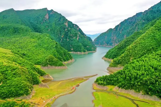 Yeliguan Tourism Area ·
 Plan your visit
Getting there
Lintan County is about 75 km in a straight line from central Gannan Tibetan Autonomous Prefecture. Search for 临潭县 in a map app to find stations and your accommodation.
Where to stay →Build your route
Start with Yeliguan Tourism Area. The linked place guides have entrance and visit details.
Continue with Gannan Tibetan Autonomous Prefecture →More in Gannan Tibetan Autonomous Prefecture
Sources & geographic information
Administrative names and parent areas: Official geographic directory · Reference date 2026-09-06.
Some facts checked against 临潭县 — Wikipedia contributors, CC BY-SA 4.0.
Some facts checked against 洮州卫城 — Wikipedia contributors, CC BY-SA 4.0.
Photo: Yeliguan Tourism Area · Source photographer · License not provided. EXIF orientation normalized; resized without changing aspect ratio; converted to WebP. No subject edits.
Map data © OpenStreetMap contributors. Pins mark approximate centres, not entrances or boundaries.