


Get to know Xiahe County

Photo adjustments
Full frame retained; resized proportionally to a maximum dimension of 960 pixels and converted to WebP quality 88. No crop, retouch, generated elements, or subject alteration. Final website rendition: full frame retained, proportionally resized to at most 720 pixels and converted to WebP. No additional retouching or subject alteration. Card displays may crop the view.
- Administrative area
- County · 县
- Part of
- Gannan Tibetan Autonomous Prefecture
- Chinese name
- 夏河县
- Local areas
- County guide
Area & population
- Area in the source
- 6,274.00 km²
- Population · 2020
- 86,355
- Administrative seat
- Labrang
Source: cited geographic source, as of the dates shown.
Setting and landscape
The land falls from north-west to south-east, and the climate is cold and humid with a marked highland-continental character; the mean annual temperature is 2.6°C. The rivers drain to the Yellow River, chiefly the Daxia River (大夏河), which runs 104 kilometres through the county, and the Tao (洮河). Grassland of good quality covers about 72 per cent of the county's land, and yaks, Ganjia sheep and Juema pigs (蕨麻猪) are among the livestock breeds raised here.
History
Labrang Monastery was founded in 1709, in the reign of the Kangxi emperor. It grew into a large monastery with six colleges, including those of medicine and the Kalachakra, 108 branch monasteries and up to 4,000 monks at its height, according to the county government. In 1927 a Labrang administrative bureau was carved out of parts of three counties, and in 1928 it became a county named Xiahe, after the Daxia River that crosses it and runs past the county town.
What to see
Labrang Monastery is one of the six principal monasteries of the Gelug school, a national 4A scenic area, and has been a national key protected site since 1982; it opened to outside visitors in 1985. Its name derives from the Tibetan labrang, glossed as "a palace of monks". About 10 kilometres from the county town, the Sangke grassland (桑科草原) is meadow grassland at an average altitude above 3,000 metres, where rapeseed fields flower in summer. Ganjia town (甘加镇), in the north-west, reaches 4,630 metres at its highest point; on the eastern part of the Ganjia plain stands the Bajiao city site (八角城遗址), a walled town with eight corners and a hollow cross-shaped plan, listed by Gansu in 1981. The county government also lists the Baishiya karst cave (白石崖溶洞) and the sacred lake of Darzong (达尔宗圣湖) among its early-developed sights.
Food and local products
The county government lists beef jerky, qula (曲拉, dried curd), juema (蕨麻, silverweed root), tsampa (糌粑), yoghurt, cheese and Tibetan pastries, made in traditional Tibetan ways, along with yak-milk powder, eight-treasure tea and Tibetan tea.
Highlights
- Labrang Monastery 拉卜楞寺: Gelug monastery founded in 1709; national key protected site since 1982.
- Sangke Grassland 桑科草原: Meadow grassland at an average altitude above 3,000 metres, 10 km from the county town, with rapeseed in flower in summer.
- Bajiao City Site 八角城遗址: Eight-cornered walled town with a cross-shaped plan in Ganjia; listed by Gansu in 1981.
- Qula 曲拉: Dried curd listed by the county among its highland products.
Sources for this guide
旅游资源 · Xiahe County People's Government
资源概况 · Xiahe County People's Government
拉卜楞寺 · Xiahe County People's Government
万顷金浪铺桑科 夏河油菜花海盛放正当时 · Xiahe County People's Government
高原特产 · Xiahe County People's Government
甘加镇 · Xiahe County People's Government
夏河县 · Wikipedia (Chinese) · CC BY-SA 4.0
Original English written from the listed sources and checked sentence by sentence against quoted extracts by a separate reviewer. Updated 2026-09-25.
Explore Xiahe County
Core places to explore, with English and Chinese names.
Places to explore around Xiahe County
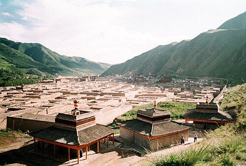 Labrang Monastery (Labuleng Si) · 拉卜楞寺
Labrang Monastery拉卜楞寺
Labrang is a working monastery and centre of learning beside the Daxia River in Xiahe. Its halls and colleges form a substantial settlement of white walls, courts and gilded roofs. The prayer-wheel route shows the monastery’s…
Read the place guide →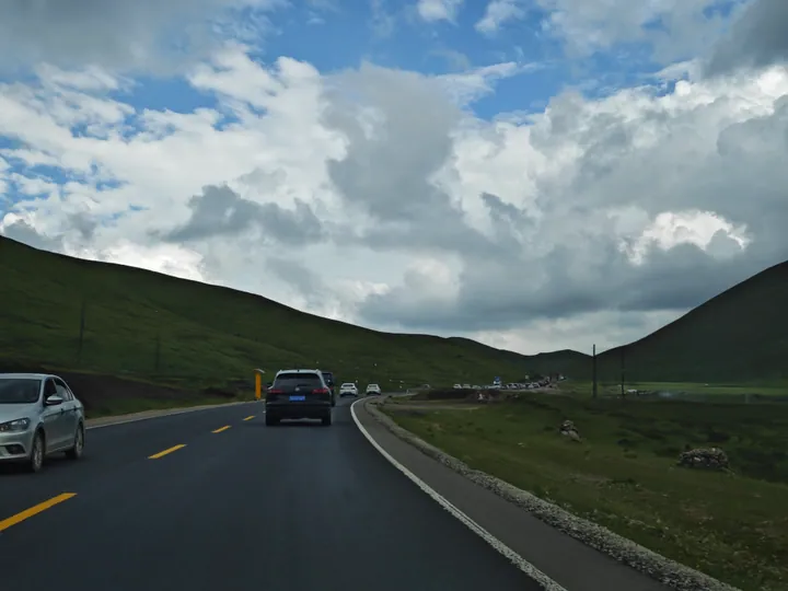 Rolling grassland hills along China National Highway 316 through the Sangke Grassland, Xiahe County · 甘肃夏河县桑科草原,316国道沿线草原风光 Source-recorded photograph date: 2023-08-10 17:25:21.
Sangke Grassland桑科草原
Sangke grassland (桑科草原) is a meadow grassland in Xiahe county, Gannan Tibetan Autonomous Prefecture, Gansu, listed in the county government's own heading as a national AA-grade tourist attraction, with 70 square kilometres of pasture at an average elevation above 3,000 m.
Read the place guide →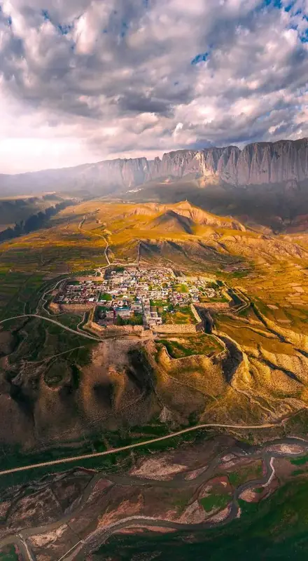 Ganjia Secret Land Visitor Area · 甘加秘境开放游览区
Ganjia Secret Land Visitor Area甘加秘境开放游览区
Ganja Mirage (甘加秘境), catalogued as an open touring area, is a plateau landscape in Ganja town, Xiahe county, Gannan Tibetan Autonomous Prefecture, Gansu, whose defining feature is 15 km of continuous Baishiya cliff above a grassland and an octagonal ancient city.
Read the place guide →Plan your visit
Getting there
Xiahe County is about 45 km in a straight line from central Gannan Tibetan Autonomous Prefecture. Search for 夏河县 in a map app to find stations and your accommodation.
Where to stay →Build your route
Labrang Monastery and Sangke Grassland are both listed here. The linked place guides have entrance and visit details.
Continue with Gannan Tibetan Autonomous Prefecture →More in Gannan Tibetan Autonomous Prefecture
Sources & geographic information
Administrative names and parent areas: Official geographic directory · Reference date 2026-09-06.
Some facts checked against 夏河县 — Wikipedia contributors, CC BY-SA 4.0.
Photo: Labrang Monastery · No machine-readable author provided. Mrfish33~commonswiki assumed (based on copyright claims). · CC BY 2.5. Wikimedia thumbnail; fitted to the ranking-card frame.

Photo: Sangke Grassland · Liuxingy · CC BY-SA 4.0. Full frame retained; proportionally resized and converted to WebP. No retouching or changes to the photographed subject. Card displays may crop the view.

Photo: Ganjia Secret Land Visitor Area · Source photographer · License not provided. EXIF orientation normalized; resized without changing aspect ratio; converted to WebP. No subject edits.
Map data © OpenStreetMap contributors. Pins mark approximate centres, not entrances or boundaries.