


Get to know Shixing County
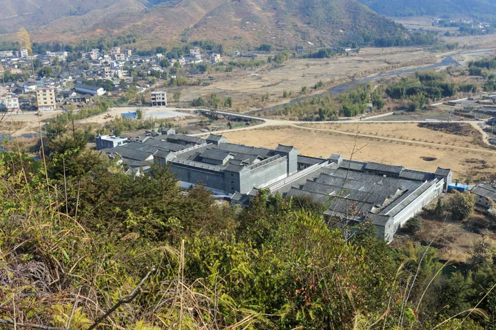
Photo adjustments
Full frame retained; proportionally resized and converted to WebP. No retouching or changes to the photographed subject. Card displays may crop the view.
- Administrative area
- County · 县
- Part of
- Shaoguan
- Chinese name
- 始兴县
- Local areas
- County guide
Area & population
- Area in the source
- 2,174.00 km²
- Population · 2020
- 198,060
Source: cited geographic source, as of the dates shown.
Setting and landscape
The centre of the county is plain, the west half-mountainous, the southeast mountainous and the northeast hilly. The county government describes Shixing as the largest small plain in northern Guangdong, long known as the "granary of northern Guangdong" (粤北粮仓). Forest covers 77.88 percent of the land. Chebaling National Nature Reserve (车八岭国家级自然保护区), a World Biosphere Reserve, lies within the county, along with Nanshan Provincial Nature Reserve (南山省级自然保护区) and Liuzhangjiashan Provincial Forest Park (刘张家山省级森林公园).
History
Shixing became a county in 263, under the Wu state of the Three Kingdoms period. The county government names the Tang chief minister Zhang Jiuling (张九龄) and the anti-Japanese war general Zhang Fakui (张发奎) as natives. Clan genealogies show that settlers arrived from Fujian and Jiangxi in the Song, Yuan and Ming dynasties. Because the Zhen River was the waterway between Lingnan and the north and Shixing was a grain store, bandits and armies came for its grain, and villages were urged to build their own fortified towers of cobble and granite, with walls no thinner than 35 to 36 centimetres.
What to see
The county has 249 weilou in fairly good condition. Mantang Hakka Enclosure (满堂客家大围) in Aizi (隘子镇), a national 4A scenic area, and Changwei (长围) in Luoba (罗坝镇) are national protected sites. Mantang stands on the riverbank where the Huangshui River (黄水河) meets the Shixia stream (石下水), with its back to the northwest and facing southeast. Hongwei (红围) in Shensuo (沈所镇) is the former seat of the Communist Party's Guangdong and Northern Guangdong provincial committees and a 3A scenic area. Shendushui Yao Ethnic Township (深渡水瑶族乡) is one of Guangdong's seven ethnic townships.
Food and local products
Qinghua rice noodles (清化米粉) and Shixing dendrobium (始兴石斛) are national geographical-indication products, and Dungang water chestnuts (顿岗马蹄) carry a geographical-indication trademark. The county also grows bayberries and loquats, and it is applying for national regional-brand status for "Zhang Jiuling Zaixiang noodles" (张九龄宰相粉), or chancellor's noodles; a heritage workshop for making Zaixiang noodles was chosen as one of Guangdong's ten outstanding intangible-heritage workshop cases.
Getting oriented
Quannan County (全南县) in Jiangxi lies to the east, Wengyuan (翁源县) to the south, Renhua (仁化县) to the west and Nanxiong (南雄市) to the north. The Shaoguan–Ganzhou railway (韶赣铁路), the Nanxiong–Shaoguan (南韶高速) and Wuhan–Shenzhen (武深高速) expressways and national roads G323 and G220 run through the county, which is 60 kilometres from Danxia Airport.
Highlights
- Mantang Hakka Enclosure 满堂客家大围: National protected site and 4A scenic area in Aizi, at the meeting of two streams.
- Changwei 长围: Weilou in Luoba listed as a national protected site.
- Hongwei 红围: Former seat of the Communist Party's Guangdong and Northern Guangdong provincial committees in Shensuo.
- Chebaling National Nature Reserve 车八岭国家级自然保护区: National nature reserve and World Biosphere Reserve.
- Qinghua rice noodles 清化米粉: National geographical-indication product.
Sources for this guide
始兴县简介 - 始兴县政府门户网站 · Shixing County People's Government
始兴客家围楼 - 始兴县政府门户网站 · Shixing County People's Government
Original English written from the listed sources and checked sentence by sentence against quoted extracts by a separate reviewer. Updated 2026-09-23.
Explore Shixing County
Core places to explore, with English and Chinese names.
Places to explore around Shixing County
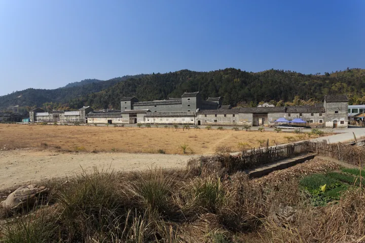 The walled Hakka compound of Mantang Hakka Walled Compound (Mantang Wei) in Shixing County, Shaoguan ·
 Plan your visit
Getting there
Shixing County is about 55 km in a straight line from central Shaoguan. Search for 始兴县 in a map app to find stations and your accommodation.
Where to stay →Build your route
Start with Mantang Hakka Walled Compound. The linked place guides have entrance and visit details.
Continue with Shaoguan →More in Shaoguan
Sources & geographic information
Administrative names and parent areas: Official geographic directory · Reference date 2026-09-06.
Photo: Mantang Hakka Walled Compound · Zhangzhugang · CC BY-SA 3.0. Full frame retained; proportionally resized and converted to WebP. No retouching or changes to the photographed subject. Card displays may crop the view.

Map data © OpenStreetMap contributors. Pins mark approximate centres, not entrances or boundaries.