


Get to know Duanzhou District
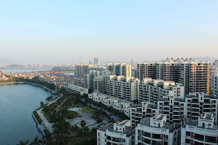
Photo adjustments
Full frame retained; resized proportionally to a maximum dimension of 960 pixels and converted to WebP quality 88. No crop, retouch, generated elements, or subject alteration. Final website rendition: full frame retained, proportionally resized to at most 720 pixels and converted to WebP. No additional retouching or subject alteration. Card displays may crop the view.
- Administrative area
- District · 市辖区
- Part of
- Zhaoqing
- Chinese name
- 端州区
- Local areas
- District guide
Area & population
- Area in the source
- 152.30 km²
- Population · 2020 census
- 602,402
Source: cited geographic source, as of the dates shown.
Setting and landscape
The Beiling range, part of the Nanling mountains, closes the district to the north, Dinghu Mountain (鼎湖山) lies to the east and Gaoyao (高要区) to the west. Between them hills, rock outcrops and wide ponds give the town its long, thin shape, and the landforms include stone forests, karst caves and isolated peaks. The climate is subtropical and monsoonal, with summer lasting around seven months and no true winter.
History
The town was the seat of Gaoyao County (高要县) from 111 BC. The name Duanzhou dates from 589, when the Sui set up a prefecture of that name here, and in 1118 it was raised to Zhaoqing Prefecture (肇庆府), which lasted through the Ming and Qing. Emperor Huizong, who had been Prince of Duan before taking the throne, credited the prefecture with his rise. The modern district was created in 1988, when Zhaoqing became a prefecture-level city, and took the old prefecture's name.
What to see
The Seven Star Crags, in the centre and south of the district, are known for their "five lakes, six ridges, seven crags and eight caves"; with Dinghu Mountain they form the Zhaoqing Star Lake scenic area, a national 5A site since 2020, and their cliff inscriptions are a national key cultural relic. The Zhaoqing city wall (肇庆古城墙), also called the Song wall, is 2,801 metres round and largely intact; it was rebuilt in brick in 1113, carries the Piyun Tower (披云楼) on its north-west stretch, and became a national key cultural relic in 2001.
Mei'an (梅庵), on a ridge in Chengxi, was founded in 996 on the spot where Huineng (惠能), the Sixth Patriarch of Chan Buddhism, is said to have planted a plum tree; its main hall keeps Song-style beams and bracketing, and it has been a national key cultural relic since 1996.
Local products
Duan inkstones (端砚), on the national intangible-heritage list since 2006, originate from Baishi and Binri villages in Huanggang (黄岗), where for generations most villagers, with no farmland, have lived by quarrying stone and making inkstones. Cut by hand from Duanxi stone, they have been made since the early Tang and are known as the foremost of inkstones.
Highlights
- Seven Star Crags 七星岩: Karst peaks and lakes in the district centre, part of a national 5A scenic area since 2020.
- Zhaoqing city wall 肇庆古城墙: Song-era wall 2,801 metres round, national key cultural relic since 2001.
- Mei'an 梅庵: Buddhist temple founded in 996 where Huineng is said to have planted a plum.
- Duan inkstone 端砚: Hand-carved inkstone from Huanggang, national intangible heritage since 2006.
Sources for this guide
端州区 - 维基百科,自由的百科全书 · Chinese Wikipedia · CC BY-SA 4.0
梅庵 (肇庆) - 维基百科,自由的百科全书 · Chinese Wikipedia · CC BY-SA 4.0
端砚制作技艺 - 中国非物质文化遗产网 · China Intangible Cultural Heritage Network (ihchina.cn)
肇庆古城墙 - 维基百科,自由的百科全书 · Chinese Wikipedia · CC BY-SA 4.0
七星岩 (肇庆) - 维基百科,自由的百科全书 · Chinese Wikipedia · CC BY-SA 4.0
Original English written from the listed sources and checked sentence by sentence against quoted extracts by a separate reviewer. Updated 2026-09-25.
Explore Duanzhou District
Core places to explore, with English and Chinese names.
Places to explore around Duanzhou District
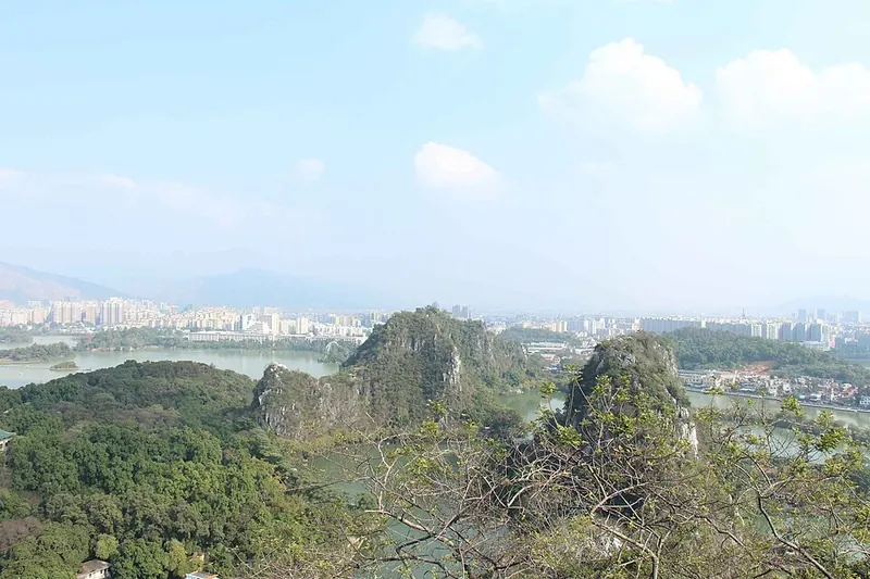 View across the limestone peaks at Seven Star Crags. Photograph date recorded by the source: 2014-10-04 16:44:57.
Seven Star Crags七星岩
Seven Star Crags brings limestone towers into the middle of Zhaoqing’s Star Lake. Paths and narrow land strips divide the water into connected sections, changing the view as each crag overlaps the next. The rock faces also carry…
Read the place guide →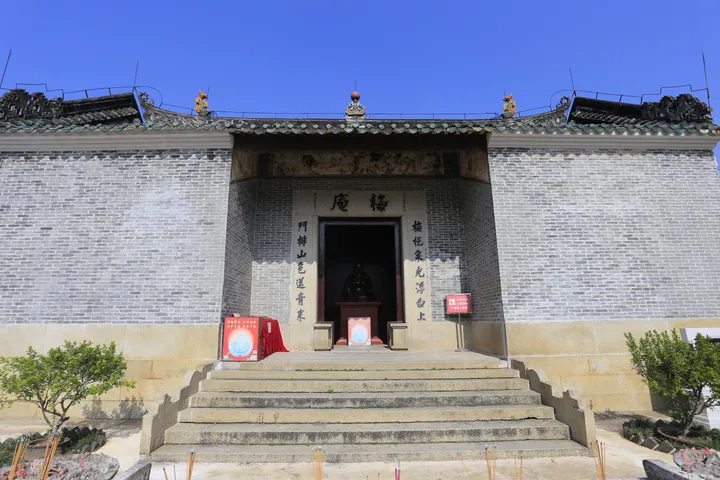 The entrance hall of Mei'an Temple, Duanzhou District, Zhaoqing · 肇庆市端州区梅庵正殿 Source-recorded photograph date: 2013-11-16 10:29:16.
Mei'an Temple梅庵
Mei'an Temple is a Buddhist temple on Mei'an Hill in Duanzhou District, Zhaoqing, Guangdong, founded in 996 during the Northern Song dynasty. It was listed as a national key cultural-relic protection unit by the State Council in November 1996.
Read the place guide →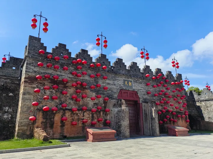 Chaotian Gate of the Zhaoqing ancient city wall, Duanzhou District · 端州区肇庆古城墙朝天门 Source-recorded photograph date: 2025-09-14 10:12:19.
Zhaoqing Ancient City Wall肇庆古城墙
A 2,801 m city wall in Zhaoqing's Duanzhou District, rebuilt in brick in 1113, with 28 bastions and the rebuilt Piyun Tower.
Read the place guide →Plan your visit
Getting there
Duanzhou District covers the centre of Zhaoqing. Search for 端州区 in a map app to find stations and your accommodation.
Where to stay →Build your route
Seven Star Crags and Mei'an Temple are both listed here. The linked place guides have entrance and visit details.
Continue with Zhaoqing →More in Zhaoqing
Sources & geographic information
Administrative names and parent areas: Official geographic directory · Reference date 2026-09-06.
Some facts checked against 端州区 — Wikipedia contributors, CC BY-SA 4.0.
Some facts checked against 梅庵 (肇庆) — Wikipedia contributors, CC BY-SA 4.0.
Some facts checked against 肇庆古城墙 — Wikipedia contributors, CC BY-SA 4.0.
Some facts checked against 七星岩 (肇庆) — Wikipedia contributors, CC BY-SA 4.0.
Photo: Seven Star Crags · Jeffery Law · CC BY-SA 4.0. Full frame retained; proportionally resized and converted to WebP. No retouching or changes to the photographed subject. Card displays may crop the view.

Photo: Mei'an Temple · Zhangzhugang · CC BY-SA 4.0. Full frame retained; proportionally resized and converted to WebP. No retouching or changes to the photographed subject. Card displays may crop the view.

Photo: Zhaoqing Ancient City Wall · Yumeto · CC BY-SA 4.0. Full frame retained; proportionally resized and converted to WebP. No retouching or changes to the photographed subject. Card displays may crop the view.

Map data © OpenStreetMap contributors. Pins mark approximate centres, not entrances or boundaries.