


Get to know Huaiji County
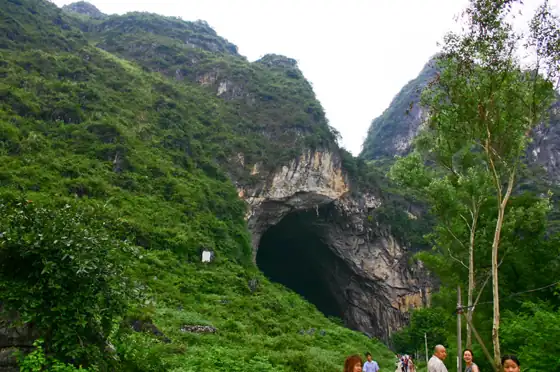
Photo adjustments
Resized and WebP compressed; subject not altered.
- Administrative area
- County · 县
- Part of
- Zhaoqing
- Chinese name
- 怀集县
- Local areas
- County guide
Area & population
- Area in the source
- 3,573.00 km²
- Population · 2020
- 805,177
Source: cited geographic source, as of the dates shown.
Setting and landscape
The land is high in the north and falls toward the southeast. Sixty peaks pass 1,000 metres, 53 of them in the north, and Dachouding (大稠顶) on the border with Yangshan County (阳山县) in Qiashui town (洽水镇) reaches 1,626 metres, the highest peak in both the county and Zhaoqing. The county seat sits at only about 53 metres in the central low hills, and a red-rock basin in the west is the main grain-growing area. In Qiaotou town (桥头镇), limestone has weathered into karst peaks 200 to 400 metres high with many caves, the best known being the through-cave of Yanyan (燕岩). With about 1,782 millimetres of rain a year, Huaiji is the wettest county in Zhaoqing, and hot springs at Shuangxing (双兴) and elsewhere reach 43 to 60°C.
History and customs
Caves around Qiaotou have yielded fossils of elephant, rhinoceros, deer and giant panda, and Lanma (栏马) and Shungang (顺岗) are late Neolithic settlement sites. The county chronicle records that the Sixth Patriarch Huineng (惠能) spent 15 years in Huaiji. Old buildings include the Wenchang Pavilion (文昌阁) of 1621 and a county library built in 1935 in the shape of the character "山" (mountain); a Tang-dynasty inscription among the Huashi (花石) cliff carvings was named one of Guangdong's ten top discoveries of 2011.
Villages around Yanyan mark the sixth day of the sixth lunar month with outings to the cave, where nestlings are caught and edible nests gathered, and young people sing antiphonal songs at night. In 1990 the county made the date its Swallow Festival. Gui'er opera (贵儿戏), the dragon-fish dance (龙鱼舞) and the spring-ox dance (春牛舞) are on the provincial intangible-heritage list.
Food and local products
Shidong tofu skin (诗洞腐竹), supple, pale yellow and able to stand long boiling, became a geographical-indication product in 2022. Other protected products are Qiaotou rock goat (桥头石山羊), Gangping cut rice noodles (岗坪切粉), Wenlang honey pomelo (汶朗蜜柚) and Xingang black tea (新岗红茶). Qiaotou also makes a porridge of cornmeal cooked with rice, raises corn-fed chickens and produces swiftlet nests.
Getting oriented
Huaiji meets Yangshan and Guangning (广宁县) to the east, Deqing (德庆县) to the south, Fengkai (封开县) and Hezhou to the west, and Lianshan (连山壮族瑶族自治县) and Liannan (连南县) to the north. The Erguang (二广), Kunming–Shantou (昆汕) and Huaiyang (怀阳) expressways and the Guiyang–Guangzhou high-speed railway (贵广高速铁路) cross the county.
Highlights
- Yanyan cave 燕岩: Through-cave in the Qiaotou karst, centre of the Swallow Festival on the sixth day of the sixth lunar month.
- Dachouding 大稠顶: At 1,626 metres the highest peak in Huaiji and in Zhaoqing.
- Wenchang Pavilion 文昌阁: Ming-dynasty building dated 1621.
- Shidong tofu skin 诗洞腐竹: Pale yellow tofu skin that holds up to boiling; geographical-indication product since 2022.
Sources for this guide
自然地理 - 怀集县人民政府网站 · Huaiji County People's Government (county chronicles office)
人文历史 - 怀集县人民政府网站 · Huaiji County People's Government (county chronicles office)
资源物产 - 怀集县人民政府网站 · Huaiji County People's Government (county chronicles office)
风俗习惯 - 怀集县人民政府网站 · Huaiji County People's Government (county chronicles office)
Original English written from the listed sources and checked sentence by sentence against quoted extracts by a separate reviewer. Updated 2026-09-23.
Explore Huaiji County
Core places to explore, with English and Chinese names.
Huaiji County 怀集县
Plan your visit
Getting there
Huaiji County is about 105 km in a straight line from central Zhaoqing. Search for 怀集县 in a map app to find stations and your accommodation.
Where to stay →More in Zhaoqing
Sources & geographic information
Administrative names and parent areas: Official geographic directory · Reference date 2026-09-06.
Map data © OpenStreetMap contributors. Pins mark approximate centres, not entrances or boundaries.