


Get to know Dinghu District
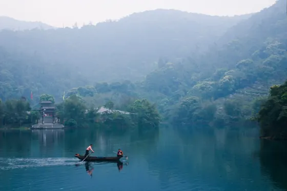
Photo adjustments
Resized and WebP compressed; subject not altered.
- Administrative area
- District · 市辖区
- Part of
- Zhaoqing
- Chinese name
- 鼎湖区
- Local areas
- District guide
Area & population
- Area in the source
- 596.00 km²
- Population · 2020
- 209,116
Source: cited geographic source, as of the dates shown.
Setting and landscape
The Xi River runs through the district between two ranges, the Dinghu Mountain range and the Lanke Mountain range (烂柯山). Jiulong Lake (九龙湖), Yanyang Lake (砚阳湖), Yanzhou Island (砚洲岛) and the Lingyang Gorge (羚羊峡) lie among them. Forest covers nearly half the district and half encircles a plain of more than 250 square kilometres.
What to see
Dinghu Mountain (鼎湖山) lies on the Tropic of Cancer and rises to 1,000.3 metres at Jilong Shan (鸡笼山). In 1956 it became China's first national nature reserve, and in 1979 it was among the first Chinese reserves to join UNESCO's Man and the Biosphere programme. Its forests range from ravine rainforest low down to montane evergreen broadleaf forest higher up. Because it stays green all year while most places on the Tropic are desert, it is called the "green jewel on the Tropic of Cancer". The name is said to come from a lake on its summit, or from a legend that the Yellow Emperor cast a tripod (ding) here. The mountain holds Qingyun Temple (庆云寺), counted among Guangdong's four great monasteries, and the Feishui Pool (飞水潭) waterfall; as part of the Xinghu scenic area it was rated a national 5A scenic area in 2020.
Yanyang Lake Park (砚阳湖公园) is rated a 3A scenic area and a provincial tourist resort.
History
The area belonged to Gaoyao County, founded in 111 BC. Neolithic people lived at Xiajiang village (夏江村) in Yong'an town (永安镇) about 5,000 years ago, and Shuikeng village (水坑村) was founded over 1,300 years ago. The district government names Sun Yat-sen, the Song official Bao Zheng (包拯), the Chan master Huineng (惠能) and the Catholic missionary Matteo Ricci among those who came here. In the early reform era, a dispute over hired labour on a fish pond contracted by Chen Zhixiong (陈志雄) of Shapu became a landmark event of China's reform and opening.
Food and local products
Dinghu was historically a "land of fish and rice" for Zhaoqing. Its best-known product is Wenqing carp (文㞧鲤), sent as tribute to successive courts; others are Zhaoqing gorgon seeds (肇实), lotus root, kudzu root (粉葛), plantains, bananas and purple-backed Gynura (紫背天葵), a leafy vegetable.
Getting oriented
The district is 70 kilometres by land from Guangzhou. National Highway 321, the Sanshui–Maoming railway (三茂铁路) and the Xi River shipping lane cross it, and the Nanning–Guangzhou and Guiyang–Guangzhou railways and the Guangzhou–Foshan–Zhaoqing intercity line meet at Zhaoqing East Station (肇庆东站).
Highlights
- Dinghu Mountain 鼎湖山: China's first national nature reserve (1956) and a UNESCO biosphere reserve since 1979.
- Qingyun Temple 庆云寺: On Dinghu Mountain; one of Guangdong's four great monasteries.
- Wenqing carp 文㞧鲤: Local carp once sent as tribute to the imperial court.
- Yanyang Lake Park 砚阳湖公园: 3A scenic area and provincial tourist resort.
Sources for this guide
肇庆市鼎湖区人民政府网站-鼎湖区(肇庆新区)概况 · Dinghu District People's Government, Zhaoqing
鼎湖山 - 维基百科,自由的百科全书 · Chinese Wikipedia · CC BY-SA 4.0
Original English written from the listed sources and checked sentence by sentence against quoted extracts by a separate reviewer. Updated 2026-09-23.
Explore Dinghu District
Core places to explore, with English and Chinese names.
Places to explore around Dinghu District
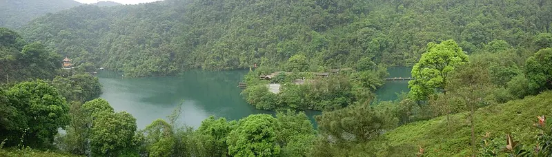 Forested slopes and water at Dinghu Mountain. Photograph date recorded by the source: 2007-05-06.
Plan your visit
Getting there
Dinghu District is about 20 km in a straight line from central Zhaoqing. Search for 鼎湖区 in a map app to find stations and your accommodation.
Where to stay →Build your route
Start with Dinghu Mountain. The linked place guides have entrance and visit details.
Continue with Zhaoqing →More in Zhaoqing
Sources & geographic information
Administrative names and parent areas: Official geographic directory · Reference date 2026-09-06.
Some facts checked against 鼎湖山 — Wikipedia contributors, CC BY-SA 4.0.
Photo: Dinghu Mountain · Memes · CC BY-SA 3.0. Full frame retained; proportionally resized and converted to WebP. No retouching or changes to the photographed subject. Card displays may crop the view.

Map data © OpenStreetMap contributors. Pins mark approximate centres, not entrances or boundaries.