


Get to know Fengkai County
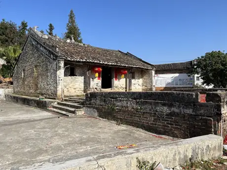
Photo adjustments
Resized and WebP compressed; subject not altered.
- Administrative area
- County · 县
- Part of
- Zhaoqing
- Chinese name
- 封开县
- Local areas
- County guide
Area & population
- Area in the source
- 2,723.00 km²
- Population · 2020 census
- 374,848
Source: cited geographic source, as of the dates shown.
Setting and landscape
The West and He rivers run through most of the county, and the county seat, Jiangkou (江口), stands at their confluence. Fengkai borders Yunan County (郁南县) to the south, Deqing County (德庆县) to the southeast and Huaiji County (怀集县) to the northeast, with Cangwu County (苍梧县) and Wuzhou (梧州) in Guangxi to the northwest. Its dense forest has earned it the name "oasis on the Tropic of Cancer", and National Highway G321 passes through Jiangkou.
History
Human tooth fossils found in the county are dated to about 148,000 years ago, more than 20,000 years older than Maba Man (马坝人). In 111 BC Emperor Wu of Han set up the Jiaozhi (交趾) inspectorate for Lingnan and placed its seat at today's Jiangkou, which the county calls the earliest capital of Lingnan. Under the Song, land east of Guangxin (广信), the old name of the area, became Guangdong and land to the west Guangxi, the origin of both province names.
Kaijian County (开建县) was created in 426 and Fengchuan County (封川县) took its name in 598. The two were merged as Fengkai County in April 1961. Mo Xuanqing (莫宣卿), whom the county calls the youngest top graduate of the imperial examinations in Chinese history, came from here.
What to see
Da Ban Shi (大斑石), in Banshi village of Xinghua town (杏花镇), is a single granite rock 191.3 metres high and 1,365 metres long; after rain, water streaming down its bare western face streaks it with colour. The Longshan scenic area (龙山景区) at Heerkou (河儿口镇) is the central area of Fengkai National Geopark (封开国家地质公园) and a provincial-level scenic area. Its karst caves formed in rock laid down in a sea some 330 to 350 million years ago: Shuanglong Cave (双龙洞) runs through the hill for over 200 metres in nine chambers, and Longquan Cave (龙泉洞) follows an underground river.
Also at Heerkou, Qiancengfeng (千层峰) is a cluster of layered sandstone and shale peaks. The 55.8-metre Guangxin Tower (广信塔), built in 2005 in Han style, gives views over the county seat and the confluence, and the 15-metre Tropic of Cancer marker in Jiangbin Park (江滨公园) has a gilded ball pierced by a 10-centimetre hole that lines up with the sun at the summer solstice. A hall at Huangyan Cave (黄岩洞) displays finds excavated at the site.
Highlights
- Da Ban Shi 大斑石: A single granite rock 191.3 metres high in Banshi village, Xinghua town.
- Longshan scenic area 龙山景区: Karst caves at Heerkou forming the central area of Fengkai National Geopark.
- Tropic of Cancer marker 北回归线标志塔: A 15-metre tower in Jiangbin Park, Jiangkou, built to be checked by the solstice sun.
- Guangxin Tower 广信塔: A 55.8-metre Han-style tower from 2005 overlooking the West and He river confluence.
Sources for this guide
肇庆市封开县人民政府网站-封开县 (悠久历史) · Fengkai County People's Government
肇庆市封开县人民政府网站-封开旅游资源 · Fengkai County People's Government
肇庆市封开县人民政府网站-龙山风景名胜区 · Fengkai County People's Government (county tourism bureau)
Original English written from the listed sources and checked sentence by sentence against quoted extracts by a separate reviewer. Updated 2026-09-23.
Explore Fengkai County
Core places to explore, with English and Chinese names.
Places to explore around Fengkai County
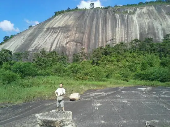 Dabanshi Rock · 大斑石
Dabanshi Rock大斑石
Dabanshi is a single rock mass that forms a hill by itself, in Fengkai county, Zhaoqing, Guangdong. The county government's own materials name the zone around it Tianxia Diyi Shi ('No.1 Rock Under Heaven'), one of five component zones of Fengkai National Geopark.
Read the place guide → AI illustration · AI 示意图(仅供参考,非该地点实拍)
Longshan Scenic Area龙山景区
Longshan is the central scenic area of Fengkai National Geopark, in Hejikou town, Fengkai county, Zhaoqing, Guangdong, popularly called 'Guangdong's Guilin'. It is a provincial-level scenic and historic area built around three developed limestone caves.
Read the place guide →Plan your visit
Getting there
Fengkai County is about 105 km in a straight line from central Zhaoqing. Search for 封开县 in a map app to find stations and your accommodation.
Where to stay →Build your route
Dabanshi Rock and Longshan Scenic Area are both listed here. The linked place guides have entrance and visit details.
Continue with Zhaoqing →More in Zhaoqing
Sources & geographic information
Administrative names and parent areas: Official geographic directory · Reference date 2026-09-06.
Photo: Dabanshi Rock · Source photographer · License not provided. EXIF orientation normalized; resized without changing aspect ratio; converted to WebP. No subject edits.
Map data © OpenStreetMap contributors. Pins mark approximate centres, not entrances or boundaries.