


Get to know Pingguo
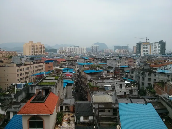
Photo adjustments
Full frame retained; proportionally resized and converted to WebP. No retouching or changes to the photographed subject. Card displays may crop the view.
- Administrative area
- County-level city · 县级市
- Part of
- Baise
- Chinese name
- 平果市
- Local areas
- County-level city guide
Area & population
- Area in the source
- 2,485.00 km²
- Population · 2011
- 507,800
- Administrative seat
- Matou (马头镇)
Source: cited geographic source, as of the dates shown.
Setting and landscape
The land falls from northwest to southeast, and earthen hills alternate with forests of rocky peaks. The climate is subtropical monsoon, with long summers, short winters, an average temperature of 21.5°C and more than 345 frost-free days a year. The Tan–Bai Expressway (坛百高速公路), the Nanning–Kunming Railway and the Nanning–Kunming high-speed line (南昆客运专线) cross the city.
History
Pingguo was created on 14 May 1951 by merging two counties. Guode (果德县) had been formed in April 1915 from the Guohua and Guide native chieftaincies (果化、归德土州) and four smaller native posts; Pingzhi (平治县) took that name in June 1934, when Silin County (思林县) was renamed. In November 2019 the county became the county-level city of Pingguo.
What to see
The Tongtian River scenic area (通天河景区), formerly Ganmo Cave (敢沫岩), is a karst cave with an underground river in Liming Township (黎明乡). Its route covers 1,680 metres on foot and 1,600 metres by boat. It is also called "Red Army Cave" (红军岩): in 1931 troops of Wei Baqun (韦拔群) from the Seventh Red Army held out there under siege for 36 days. It became a national 4A scenic area in 2013.
Luxian Lake National Wetland Park (芦仙湖国家湿地公园) takes in the Bujian (布见水库) and Nama (那马水库) reservoirs, the Xinxu River (新圩河) and the forested slopes on either side. It was approved as a pilot in 2014 and passed its final inspection as a national wetland park in December 2019.
At Sancenggang (三层岗) in Guohua (果化镇), near the north bank of the Youjiang, the Deng Xiaoping Footsteps Tour follows routes Deng took during the revolutionary period. Its "Red Army Road" (红军路) is a 1.89-kilometre walking trail from Pingniu hamlet (平牛屯); the route opened on 25 June 2011.
Food and local products
Tofu balls (豆腐丸) are made by mashing fresh tofu, wrapping it around minced pork, shrimp, peanut, garlic, spring onion, wood ear and five-spice, and frying until brown; they are then braised with soy sauce or cooked in a hotpot. Hehuan zongzi (合欢粽) are two small unfilled sticky-rice dumplings pressed together and tied with five straw bands; families make them at New Year as a sign of togetherness, and they go into New Year gifts for newly married in-laws. The Zhuang also make five-colour sticky rice (五色糯米饭) for festivals such as Qingming and the third day of the third lunar month, dyeing it black with maple leaves, yellow with gardenia and red or purple with a dye plant called honglancao (红蓝草).
Highlights
- Tongtian River scenic area 通天河景区: Karst cave with a 1,600-metre underground boat route; national 4A since 2013.
- Luxian Lake National Wetland Park 芦仙湖国家湿地公园: Reservoirs and river wetland confirmed as a national wetland park in December 2019.
- Sancenggang Deng Xiaoping Footsteps Tour 三层岗·邓小平足迹之旅: Revolutionary-history walking route in Guohua, opened on 25 June 2011.
- Hehuan zongzi 合欢粽: Paired unfilled rice dumplings tied with five straw bands, made at New Year.
Sources for this guide
通天河景区 - 景点介绍 - 广西百色平果市人民政府门户网站 · Pingguo City People's Government
芦仙湖风景区 - 景点介绍 - 广西百色平果市人民政府门户网站 · Pingguo City Bureau of Culture, Sports, Radio, Television and Tourism
三层岗 - 景点介绍 - 广西百色平果市人民政府门户网站 · Pingguo City Bureau of Culture, Sports, Radio, Television and Tourism
豆腐丸 - 美食平果 - 广西百色平果市人民政府门户网站 · Pingguo City People's Government Office
合欢粽 - 美食平果 - 广西百色平果市人民政府门户网站 · Pingguo City People's Government
花糯米饭 - 美食平果 - 广西百色平果市人民政府门户网站 · Pingguo City People's Government
平果市 - 维基百科,自由的百科全书 · Wikipedia (Chinese) · CC BY-SA 4.0
Original English written from the listed sources and checked sentence by sentence against quoted extracts by a separate reviewer. Updated 2026-09-23.
Explore Pingguo
Core places to explore, with English and Chinese names.
Plan your visit
Getting there
Pingguo is about 120 km in a straight line from central Baise. Search for 平果市 in a map app to find stations and your accommodation.
Where to stay →More in Baise
Sources & geographic information
Administrative names and parent areas: Official geographic directory · Reference date 2026-09-06.
Some facts checked against 平果市 — Wikipedia contributors, CC BY-SA 4.0.
Map data © OpenStreetMap contributors. Pins mark approximate centres, not entrances or boundaries.