


Get to know Tianlin County
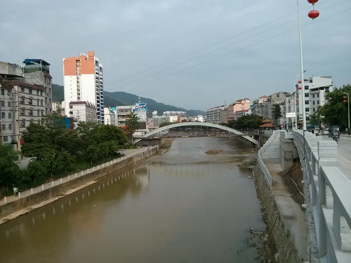
Photo adjustments
Full frame retained; proportionally resized and converted to WebP. No retouching or changes to the photographed subject. Card displays may crop the view.
- Administrative area
- County · 县
- Part of
- Baise
- Chinese name
- 田林县
- Local areas
- County guide
Area & population
- Area in the source
- 5,584.00 km²
- Population · 2020
- 224,828
- Administrative seat
- Leli
Source: cited geographic source, as of the dates shown.
Setting and landscape
The county lies on the transition from the hills of Guangxi to the Yunnan–Guizhou Plateau. More than 200 peaks rise above 1,000 metres, and elevations range from river valleys at about 200 metres to 2,062.5 metres. Karst hills with many caves are concentrated in the northeast and northwest; the rest is earthen hills under dense forest. Differences in terrain, sunshine, heat and rainfall give the county warm, cool and cold climate zones, and its rivers drain to two systems, the Youjiang (右江) and the Nanpan River (南盘江).
History
In the winter of 1935 eight townships taken from Xilin (西林县), Xilong (西隆县) and Lingyun (凌云县) counties formed Tianxi County (田西县), governed from Lucheng (潞城). In August 1951 Xilin County was abolished, four of its townships were added, and the enlarged county was named Tianlin.
Ding'an (定安镇), once the seat of Xilin County, was the scene of the Xilin Incident (西林教案): in February 1856 the newly appointed magistrate Zhang Mingfeng (张鸣凤) executed a French priest, Ma Lai (马赖), and Napoleon III used the case as a pretext for the Second Opium War. The site is now a national 3A scenic area. The Red Eighth Army passed through the county in April 1930.
What to see
Cenwanglaoshan (岑王老山), a national nature reserve, is described by the county government as the fourth-highest peak in Guangxi. Other named spots are Wanjishan Forest Park (万吉山森林公园) at the county seat, the cliffs of Meihua Mountain (梅花山) in Jiuzhou (旧州镇), the Aishan Manor rural tourism area (爱善庄园), Sanchuan Cave (三穿洞), Zhouma Gorge (周马峡谷) and the Liulong bamboo forest (六隆竹海).
Northern Zhuang opera (北路壮剧) began in the late Ming at Anlong stockade (安隆寨), today's Jiuzhou; a libretto, Taiping Chun (太平春, "Peaceful Spring"), dates from 1681. Zhuang opera was listed in the first national intangible heritage list in 2006, and Tianlin has held a Zhuang opera festival since 2007.
Food and local products
Badu bamboo shoots (八渡笋) take their name from Badu Yao Township (八渡瑶族乡), where they were first grown; they were a Qing tribute item and appear in a palace menu of the Jiaqing era. They became a protected geographical indication product in May 2010. Tianlin is also known for wild lingzhi mushrooms (灵芝), registered as an agricultural geographical indication in February 2018, and for camellia oil.
Getting oriented
The Nanning–Kunming Railway, the Shantou–Kunming (汕昆) and He–Xi (贺西) expressways and national roads 324 and 357 pass through the county. The county government is in Leli (乐里镇).
Highlights
- Cenwanglaoshan 岑王老山: National nature reserve; listed by the county as the fourth-highest peak in Guangxi.
- Xilin Incident site 西林教案发生地: Site of the 1856 execution used by France as a pretext for the Second Opium War; national 3A scenic area.
- Northern Zhuang opera 北路壮剧: Began in the late Ming at Anlong stockade, now Jiuzhou; libretto dated 1681.
- Badu bamboo shoots 八渡笋: Qing tribute shoots from Badu; geographical indication product since May 2010.
Sources for this guide
田林县基本情况 - 田林概况 - 广西百色田林县人民政府门户网站 · Tianlin County People's Government
地理环境 - 广西百色田林县人民政府门户网站 · Tianlin County People's Government
建置沿革 - 历史沿革 - 广西百色田林县人民政府门户网站 · Tianlin County People's Government
Original English written from the listed sources and checked sentence by sentence against quoted extracts by a separate reviewer. Updated 2026-09-23.
Explore Tianlin County
Core places to explore, with English and Chinese names.
Tianlin County 田林县
Plan your visit
Getting there
Tianlin County is about 60 km in a straight line from central Baise. Search for 田林县 in a map app to find stations and your accommodation.
Where to stay →More in Baise
Sources & geographic information
Administrative names and parent areas: Official geographic directory (dmfw.mca.gov.cn) · Reference date 2026-09-06.
Map data © OpenStreetMap contributors. Pins mark approximate centres, not entrances or boundaries.