


Get to know Ziyuan County
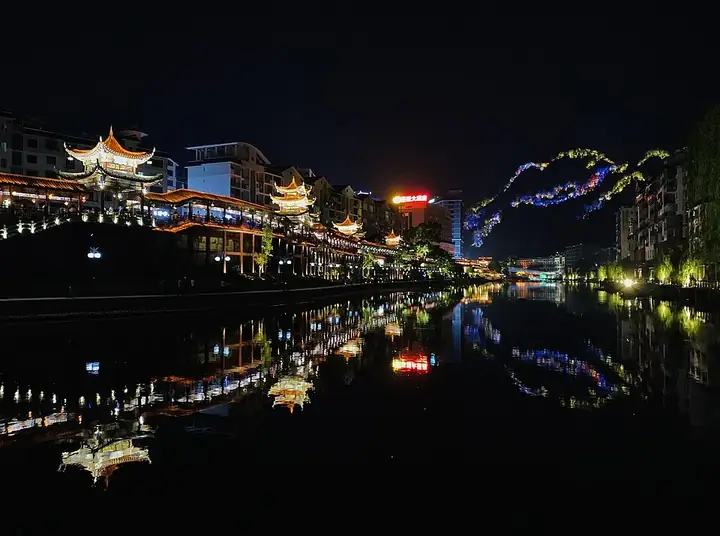
Photo adjustments
Full frame retained; resized proportionally to a maximum dimension of 960 pixels and converted to WebP quality 88. No crop, retouch, generated elements, or subject alteration. Final website rendition: full frame retained, proportionally resized to at most 720 pixels and converted to WebP. No additional retouching or subject alteration. Card displays may crop the view.
- Administrative area
- County · 县
- Part of
- Guilin
- Chinese name
- 资源县
- Local areas
- County guide
Area & population
- Area in the source
- 1,961.14 km²
- Population · 2020
- 139,212
- Administrative seat
- Ziyuan Town
Source: cited geographic source, as of the dates shown.
Setting and landscape
The county government places Ziyuan 98 kilometres from central Guilin, with Quanzhou (全州), Xing'an (兴安) and Longsheng (龙胜) counties to the east, south and south-west and Hunan's Chengbu (城步) and Xinning (新宁) counties to the west and north. Mao'er Mountain (猫儿山), which the county calls the highest peak in South China, stands within its borders. Most of the county lies above 800 metres, and it is among the Guangxi counties where frost, snow and ice come earliest and last longest. Forest covers about 83 percent of the land, and nationally protected trees such as the Ziyuan fir (资源冷杉) grow here.
History
The area was known as Xiyan (西延) from the early Song and was long governed from Quanzhou. It came under Guilin prefecture together with Quanzhou at the start of the Ming, and Ziyuan County was formed in 1935 from Xiyan and neighbouring townships of Quanzhou and Xing'an. It was abolished in 1952 and restored in 1954. Ziyuan is one of Guangxi's four counties that speak Xiang Chinese (湘语), and since 1995 it has received the policy treatment of an autonomous county, as a county where Miao and Yao people are concentrated.
What to see
The county government credits Bajiaozhai (八角寨) with three titles: world natural heritage, national forest park and national geopark. The Zi River scenic area, with red Danxia hills above clear water, is promoted as the top river-rafting trip in South China, and the Wupai River (五排河) is known for adventure rafting. The county also lists Danxia hot springs, the Tianmen Mountain (天门山) eco-scenic area and the Baoding Waterfall (宝鼎瀑布), which falls in nine steps. Bajiaozhai, the Zi River with Tianmen Mountain, and the Zijiang Lantern Valley (资江灯谷) became national 4A scenic areas in 2018.
Festivals and local products
The River Lantern Song Festival (河灯歌节), held for the traditional "seventh-month half" (七月半), was added to the national intangible-heritage list in 2014. Ziyuan is a base for the "three-tree" medicines eucommia, phellodendron and magnolia bark, and it also grows gastrodia; mountain products include fern shoots, bamboo shoots, shiitake, wood ear, tea, lilies and kiwi fruit.
Highlights
- Bajiaozhai 八角寨: Danxia area holding world natural heritage, national forest park and national geopark titles; 4A since 2018.
- Zi River scenic area 资江景区: Red Danxia hills and clear water, promoted as the top rafting river in South China.
- Baoding Waterfall 宝鼎瀑布: Waterfall that drops in nine steps.
- River Lantern Song Festival 河灯歌节: Seventh-month festival on the national intangible-heritage list since 2014.
Explore Ziyuan County
Core places to explore, with English and Chinese names.
Places to explore around Ziyuan County
 Bajiaozhai · Guangxi Side · 八角寨·广西侧
Bajiaozhai · Guangxi Side八角寨·广西侧
Bajiaozhai’s Guangxi side offers a landscape of red-bed ridges and tightly grouped, rounded peaks. The viewpoint called Whales in the Sea looks across the clustered hills; in mist, the analogy becomes particularly clear. Dragon…
Read the place guide → Bajiaozhai Scenic Area · 八角寨
Bajiaozhai Scenic Area八角寨
Bajiaozhai (八角寨) is a Danxia mesa massif in the north of Meixi town, Ziyuan County, Guilin, Guangxi, rising to 818 metres and named for the eight horn-like angles of its main peak; the scenic area around it adjoins Xinning County in Hunan.
Read the place guide → AI illustration · AI 示意图(仅供参考,非该地点实拍)
Zi River Scenic Area资江
Zijiang (资江) is a river and Danxia scenic area in Ziyuan County, Guilin, which the county government describes as a landscape of red hills and green water; two further 'Zijiang'-named scenic areas, Zijiang-Tianmenshan and Zijiang Denggu, were among three the county graded nationally 4A in 2018.
Read the place guide →Plan your visit
Getting there
Ziyuan County is about 90 km in a straight line from central Guilin. Search for 资源县 in a map app to find stations and your accommodation.
Where to stay →Build your route
Bajiaozhai · Guangxi Side and Bajiaozhai Scenic Area are both listed here. The linked place guides have entrance and visit details.
Continue with Guilin →More in Guilin
Sources & geographic information
Administrative names and parent areas: Official geographic directory · Reference date 2026-09-06.
Some facts checked against 资源县 — Wikipedia contributors, CC BY-SA 4.0.
Photo: Bajiaozhai · Guangxi Side · Source photographer · License not provided. EXIF orientation normalized; resized without changing aspect ratio; converted to WebP. No subject edits.
Photo: Bajiaozhai Scenic Area · Source photographer · License not provided. EXIF orientation normalized; resized without changing aspect ratio; converted to WebP. No subject edits.
Map data © OpenStreetMap contributors. Pins mark approximate centres, not entrances or boundaries.