


Get to know Xiangshan District

Photo adjustments
Full frame retained; proportionally resized and converted to WebP. No retouching or changes to the photographed subject. Card displays may crop the view.
- Administrative area
- District · 市辖区
- Part of
- Guilin
- Chinese name
- 象山区
- Local areas
- District guide
Area & population
- Area in the source
- 88.00 km²
- Population · 2020
- 286,872
- Administrative seat
- Nanmen Subdistrict
Source: cited geographic source, as of the dates shown.
History
From 1368, under the Ming, the seat of Lingui County (临桂县) stood inside today's district, on the site now occupied by the Guilin hospital of traditional Chinese medicine on Lingui Road; it was the first county seat within the district's area. Peiyi District (培义区), formed in 1942 and kept after 1949, was the district's forerunner, and Xiangshan District itself was set up in July 1979 when Guilin replaced its urban communes with four districts. Remains found in Zengpiyan (甑皮岩) and Baojiyan (宝积岩) caves show, according to the Guilin city government, that people lived around Guilin about 10,000 years ago; the Zengpiyan site is on China's list of the hundred great archaeological discoveries of the past century.
What to see
Elephant Trunk Hill stands where the Li River meets the Peach Blossom River (桃花江) and is named for its likeness to an elephant drinking from the river. The scenic area covers about 11.88 hectares, holds cliff inscriptions and Buddhist carvings, was made the city emblem in 1995 and was rated 5A in 2017.
The Sun and Moon Pagodas (日月双塔) were rebuilt in 2001 on the base of a Tang-dynasty pagoda and stand on Guilin's central axis beside the hill; their underground museum shows Buddhist objects excavated from the Tang pagoda, and the district government bills the copper Sun Pagoda as the tallest copper pagoda in the world.
Nanxi Hill (南溪山), about a kilometre from the railway station, became a public park in 1974. Its two peaks carry about 180 cliff inscriptions left since the Tang, a national key cultural relics site since 2003, and its caves include White Dragon Cave (白龙洞), the largest, and Liuxian Rock (刘仙岩), linked to the Song Taoist Liu Zhongyuan (刘仲远).
Highlights
- Elephant Trunk Hill 象鼻山: Guilin's city emblem since 1995, at the meeting of the Li and Peach Blossom rivers; 5A scenic area since 2017.
- Sun and Moon Pagodas 日月双塔: Rebuilt in 2001 on a Tang pagoda base, with an underground museum of excavated Tang Buddhist objects.
- Nanxi Hill 南溪山: About 180 cliff inscriptions from the Tang onwards, a national key cultural relics site since 2003.
- Zengpiyan Site Museum 甑皮岩遗址博物馆: Cave site showing human activity around Guilin about 10,000 years ago; listed among China's hundred great archaeological discoveries.
Sources for this guide
历史沿革 - 象山区人民政府 · Xiangshan District People's Government, Guilin
象山景区 - 辖区景点 - 象山区人民政府 · Xiangshan District People's Government, Guilin
城市名片 - 桂林市人民政府 · Guilin Municipal People's Government
日月双塔 - 辖区景点 - 象山区人民政府 · Xiangshan District People's Government, Guilin
南溪山景区 - 辖区景点 - 象山区人民政府 · Xiangshan District People's Government, Guilin
古城史话 - 桂林市人民政府 · Guilin Municipal People's Government
文化遗产 - 桂林市人民政府 · Guilin Municipal People's Government
象山区 - 维基百科,自由的百科全书 · Wikipedia (Chinese) · CC BY-SA 4.0
Original English written from the listed sources and checked sentence by sentence against quoted extracts by a separate reviewer. Updated 2026-09-25.
Explore Xiangshan District
Core places to explore, with English and Chinese names.
Places to explore around Xiangshan District
 Elephant Trunk Hill (Xiangbishan) · 象鼻山
Elephant Trunk Hill象鼻山
Elephant Trunk Hill stands where the Taohua and Li rivers meet in Guilin. The limestone outline resembles an elephant lowering its trunk into the water, with a rounded opening beneath the arch. That opening is known as…
Read the place guide → Sun and Moon Pagodas · 日月双塔
Sun and Moon Pagodas日月双塔
The Sun and Moon Pagodas rise from Shan Lake in central Guilin as a paired waterside landmark. Both have octagonal plans, but their finishes and proportions differ: the Sun Pagoda is faced in bronze, while the Moon Pagoda uses…
Read the place guide →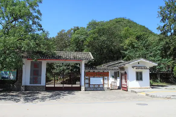 Zengpiyan Site Museum · 甑皮岩遗址博物馆
Zengpiyan Site Museum甑皮岩遗址博物馆
Zengpiyan preserves a Neolithic cave site together with a museum explaining the discoveries made there. Stone tools and pottery fragments connect the cave with the practical activities of its former inhabitants, while the…
Read the place guide →Plan your visit
Getting there
Xiangshan District covers the centre of Guilin. Search for 象山区 in a map app to find stations and your accommodation.
Where to stay →Build your route
Elephant Trunk Hill and Sun and Moon Pagodas are less than 1 km apart. The linked place guides have entrance and visit details.
Continue with Guilin →More in Guilin
Sources & geographic information
Administrative names and parent areas: Official geographic directory · Reference date 2026-09-06.
Some facts checked against 象山区 — Wikipedia contributors, CC BY-SA 4.0.
Photo: Elephant Trunk Hill · xiquinhosilva · CC BY 2.0. Wikimedia thumbnail; fitted to the ranking-card frame.
.jpg)
Photo: Sun and Moon Pagodas · King of Hearts · CC BY-SA 4.0. Wikimedia thumbnail; fitted to the ranking-card frame.

Photo: Zengpiyan Site Museum · Zhangzhugang · CC BY-SA 3.0. EXIF orientation normalized; resized without changing aspect ratio; converted to WebP. No subject edits.

Map data © OpenStreetMap contributors. Pins mark approximate centres, not entrances or boundaries.