


Get to know Hezhang County
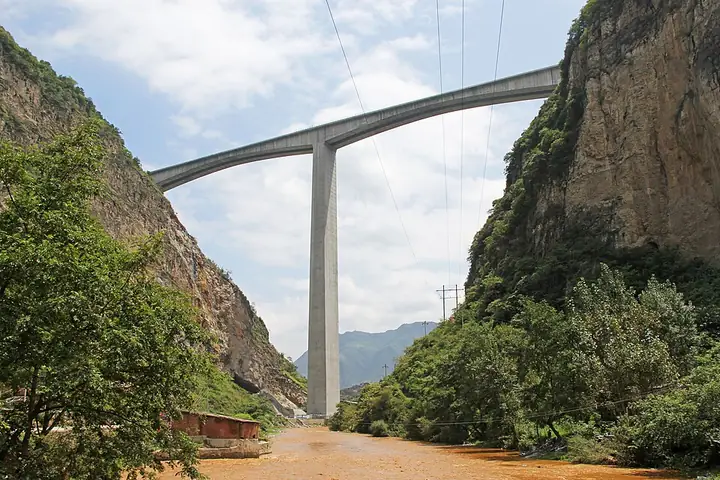
Photo adjustments
Full-frame source proportionally resized and converted to WebP for display. No subject alteration. Source-supplied marks and edits remain; cards may crop the view.
- Administrative area
- County · 县
- Part of
- Bijie City
- Chinese name
- 赫章县
- Local areas
- County guide
Area & population
- Area in the source
- 3,242.74 km²
- Population · 2010
- 649,357
- Administrative seat
- Shuanghe
Source: cited geographic source, as of the dates shown.
Setting and landscape
Heights range from 1,230 metres to 2,900.6 metres, with an average of 1,996 metres, and the county government describes ranges of peaks cut by deep river valleys. Qixingguan District (七星关区) and Nayong County (纳雍县) lie to the east, Weining County (威宁县) to the west, and the Zhongshan (钟山区) and Shuicheng (水城区) districts of Liupanshui (六盘水) to the south. The Bijie–Weining Expressway (毕威高速) and National Road G326 cross the county from east to west, and the Zhenxiong–Shuicheng Expressway (镇水高速) and Provincial Road S212 run north to south.
History
In the Warring States period the area belonged to Yelang (夜郎), the kingdom remembered in the idiom "Yelang thinks itself great" (夜郎自大). Yi-language texts record Kele (可乐乡), whose Yi name means "great central city", as Yelang's political and cultural centre at its height. The Kele site (可乐遗址), on both banks of the Kele River, dates from the Warring States to the Han (475 BC to AD 220): a Han town with rammed-earth walls south of the river, a Yelang settlement about 1 km away to the north, and 14 burial groups. Some of the Yelang graves use "head-covering burial" (套头葬), a form rare in China. The site was named one of the country's ten major archaeological discoveries of 2001.
Hezhang was also a battleground of the Red Army's 2nd and 6th Army Groups and keeps more than ten revolutionary sites, including the Yemachuan meeting site (野马川会议遗址). The county government calls Hezhang the birthplace of the Bijie Pilot Zone for development-based poverty relief and ecological construction, approved by the State Council in June 1988, and traces it to a 1985 Xinhua internal report on poverty in Haique village (海雀村).
What to see
Jiucaiping (韭菜坪) is known for its belt of wild chive flowers, and the stone forest on Little Jiucaiping (小韭菜坪) was rated one of China's top ten summer-retreat mountains three years running. Other sights include the Axi Lixi grassland (阿西里西大草原), which the county government calls a "grassland in the clouds", and the Jiugushui hot-spring resort (九股水温泉度假区). More than 100 old Yi-script stone inscriptions survive here. The Yi bell dance (铃铛舞) is on the second national intangible-heritage list, the Miao "great migration dance" (大迁徙舞) on the first provincial list, and the Yi Cuotaiji (撮泰吉) on the sixth provincial list.
Food and local products
The county holds the titles "home of walnuts", "home of cherries" and "home of pinellia" (半夏). It promotes thin-shelled walnuts, sweet cherries, Kele pigs (可乐猪) and gastrodia (天麻), used as both food and medicine.
Highlights
- Kele site 可乐遗址: Warring States to Han site with a Han walled town, a Yelang settlement and 14 burial groups on the Kele River.
- Jiucaiping 韭菜坪: Upland known for its belt of wild chive flowers; the Little Jiucaiping stone forest was rated a top ten summer-retreat mountain three years running.
- Axi Lixi grassland 阿西里西大草原: Grassland the county government calls a "grassland in the clouds".
- Yi bell dance 铃铛舞: On the second national intangible-heritage list.
Sources for this guide
赫章简介 - 赫章县人民政府 · Hezhang County People's Government
名胜古迹 - 赫章县人民政府 · Hezhang County People's Government
Original English written from the listed sources and checked sentence by sentence against quoted extracts by a separate reviewer. Updated 2026-09-24.
Explore Hezhang County
Core places to explore, with English and Chinese names.
Places to explore around Hezhang County
 AI illustration · AI 示意图(仅供参考,非该地点实拍)
Axilixi Jiucaiping Plateau阿西里西韭菜坪
Axilixi Jiucaiping is a high-plateau scenic area in the south-west of Hezhang County, Bijie, Guizhou, at the meeting point of Xingfa, Shuitangbao and Baiguo townships. Its subject is an upland covered in wild Chinese chives, and the Bijie municipal government also calls it the Da Jiucaiping scenic area.
Read the place guide →AI illustration · AI 示意图(仅供参考,非该地点实拍)Axilixi Ertaipo Grassland阿西里西二台坡
Ertaipo is another name for the Axilixi grassland in Hezhang County, Bijie, Guizhou, a high pasture landscape around 2,300 metres above sea level. It is also known as Yunding Caoyuan, and is one of the main scenic areas of the Guizhou Axilixi tourism region.
Read the place guide →Plan your visit
Getting there
Hezhang County is about 60 km in a straight line from central Bijie City. Search for 赫章县 in a map app to find stations and your accommodation.
Where to stay →Build your route
Axilixi Jiucaiping Plateau and Axilixi Ertaipo Grassland are both listed here. The linked place guides have entrance and visit details.
Continue with Bijie City →More in Bijie City
Sources & geographic information
Administrative names and parent areas: Official geographic directory · Reference date 2026-09-06.
Map data © OpenStreetMap contributors. Pins mark approximate centres, not entrances or boundaries.