


Get to know Jinsha County
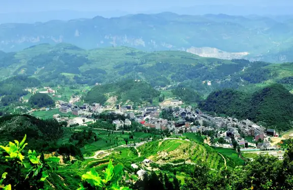
Photo adjustments
EXIF orientation normalized; resized without changing aspect ratio; converted to WebP. No subject edits.
- Administrative area
- County · 县
- Part of
- Bijie City
- Chinese name
- 金沙县
- Local areas
- County guide
Area & population
- Area in the source
- 2,523.23 km²
- Population · 2010
- 560,575
- Administrative seat
- Guchang Subdistrict
Source: cited geographic source, as of the dates shown.
Setting and landscape
Ground rises toward the southwest. The east is gently rolling, with karst hills, troughs and flat valley fields; the centre, apart from deeply cut river valleys and broken ridges, has broad valleys and flats strung along rivers; the west is broken country with narrow valleys and continuous ridges. Karst landforms dominate. The climate is humid north-subtropical monsoon, with a mean annual temperature of 15 to 18°C. Lengshuihe National Forest Park (冷水河国家级森林公园), Sanzhangshui Provincial Forest Park (三丈水省级森林公园) and the plantain-lily flower fields at Yankong (岩孔) are among the natural areas the county government lists. The Hangzhou–Ruili (杭瑞), Guiyang–Jinsha (贵金) and Renhuai–Wangmo (仁望) expressways cross the county.
History
Jinsha was once called Dagu Xinchang (打鼓新场), counted first among the four famous towns of northern Guizhou. The county was set up on 1 July 1941 from townships transferred out of Qianxi (黔西县), Dading (大定县) and Zunyi (遵义县) counties, and the People's Government took office on New Year's Day 1950. Six sites are national key protected monuments, among them the Jiangxi Guild Hall (江西会馆), the Tea Horse Road (茶马古道) and the Yishenglong trading house (义盛隆商号). Revolutionary sites include the Qian Zhuangfei Martyrs' Cemetery (钱壮飞烈士陵园) and three ferry points where the Red Army crossed the Wujiang (乌江) southward.
Food and local products
Jinsha calls itself the home of tribute tea: Qingchi tea (清池茶) was listed as a palace tribute in the Han dynasty. Jinsha tribute tea, Jinsha Huisha liquor (金沙回沙酒), Yumo vinegar (禹谟醋), Wanzi chillies (湾子辣椒) and Jinsha black goats (金沙黑山羊) carry national geographical-indication protection.
Jinsha mutton rice noodles (金沙羊肉粉) are most closely tied to Shatu town (沙土镇), where hawkers sold mutton soup from pots at the market in the Qianlong reign of the Qing; rice noodles were later added. The making technique went on the provincial intangible-heritage list in 2019. The dish uses free-range local black goat, noodles as thick as chopsticks with a slight sourness, and chilli oil made by frying ground Dafang wrinkled chillies (大方皱椒) in mutton fat.
What to see
The county's 3A scenic areas include the sauce-aroma liquor culture area (酱酒文化旅游景区), the Andi hot springs (金沙安底温泉景区) and the Xixiangji riverside Buyi area (西鄕季·滨江布依景区).
Highlights
- Lengshuihe National Forest Park 冷水河国家级森林公园: National forest park listed by the county among its natural areas.
- Jiangxi Guild Hall 江西会馆: One of six national key protected monuments in the county.
- Qingchi tea 清池茶: Sent to the imperial court as tribute in the Han dynasty.
- Jinsha mutton rice noodles 金沙羊肉粉: Shatu town dish on the provincial intangible-heritage list since 2019, with chilli oil fried in mutton fat.
Sources for this guide
金沙县人民政府门户网-金沙简介 · Jinsha County People's Government
金沙县人民政府门户网-历史沿革 · Jinsha County People's Government
金沙羊肉粉 · Jinsha County People's Government (Jinsha tourism development office)
Original English written from the listed sources and checked sentence by sentence against quoted extracts by a separate reviewer. Updated 2026-09-24.
Explore Jinsha County
Core places to explore, with English and Chinese names.
Places to explore around Jinsha County
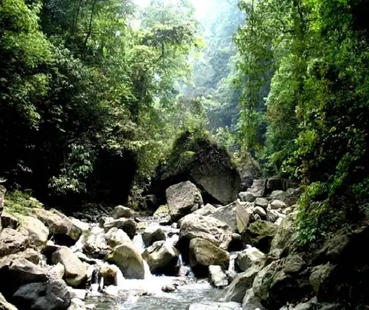 Lengshui River ·
 Plan your visit
Getting there
Jinsha County is about 95 km in a straight line from central Bijie City. Search for 金沙县 in a map app to find stations and your accommodation.
Where to stay →Build your route
Start with Lengshui River. The linked place guides have entrance and visit details.
Continue with Bijie City →More in Bijie City
Sources & geographic information
Administrative names and parent areas: Official geographic directory · Reference date 2026-09-06.
Photo: Lengshui River · Source photographer · License not provided. EXIF orientation normalized; resized without changing aspect ratio; converted to WebP. No subject edits.
Map data © OpenStreetMap contributors. Pins mark approximate centres, not entrances or boundaries.