


Get to know Cengong County
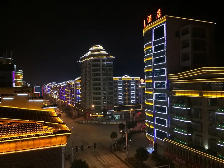
Photo adjustments
Full-frame source proportionally resized and converted to WebP for display. No subject alteration. Source-supplied marks and edits remain; cards may crop the view.
- Administrative area
- County · 县
- Part of
- Qiandongnan Miao and Dong Autonomous Prefecture
- Chinese name
- 岑巩县
- Local areas
- County guide
Area & population
- Area in the source
- 1,486.50 km²
- Population · 2010
- 162,008
- Administrative seat
- Siyang
Source: cited geographic source, as of the dates shown.
History
The Tang set up Sizhou in 618 as a loosely controlled frontier prefecture. The Cengong county government describes old Sizhou as a crossroads on the routes between Chu (楚), Guizhou and Yunnan, through which the politics, culture and technology of central China first reached Guizhou. In 1413, when the Ming abolished the Sizhou and Sinan (思南) pacification commissions and created eight prefectures under the new Guizhou administration, Sizhou became one of them. The prefecture was turned into Si County in 1913 and renamed Cengong in 1930. In 2001 the county seat moved from Siyang (思旸) to Xinxing (新兴村) on the Wuyang River (舞阳河).
What to see
The Sizhou old town (思州古城) sits between hills on all four sides: Fenghuang Ridge (凤凰岭) to the east and Longtou Mountain (龙头山) to the north. Its walls were built in 1415 by the prefect Cui Yanjun (崔彦俊), and a stone wall around the hill behind was added in 1576. The county government counts more than 50 Ming and Qing buildings in the old town, among them the Guanyin Pavilion (观音阁), the Kuixing Pavilion (魁星阁), the prefectural office and Jiangxi and Hunan guild halls.
The Long'ao River (龙鳌河) rises where Shiqian (石阡), Jiangkou (江口) and Cengong meet and flows 39.7 kilometres through Kaiben (凯本), Yangqiao (羊桥) and Shuiwei (水尾) into the Wushui (舞水), part of the Yuan River (沅水) system. The 16.5-kilometre stretch from Xiamaoma (下茂马) in Yangqiao to Baishuizhai (白水寨) in Shuiwei is the scenic section, with waterfalls, karst caves and cliffs; Guizhou confirmed it as a national 4A scenic area in late 2024.
Crafts and local products
Sizhou inkstone making (思州石砚制作技艺) joined the national intangible-heritage list in 2021. The stone comes from karst valleys along the Longjiang (龙江河) and Long'ao rivers and is flecked with gold-coloured specks, so carvers plan each design around where the specks fall; common motifs include dragons, magpies on plum branches and the Eight Views of Sizhou. The county is also a national base for hybrid rice seed production.
Highlights
- Sizhou old town 思州古城: Ming prefectural town walled in 1415, with more than 50 Ming and Qing buildings.
- Long'ao River 龙鳌河: 16.5-kilometre scenic stretch of waterfalls and caves; national 4A since 2024.
- Sizhou inkstones 思州石砚: Gold-flecked stone carved into inkstones; national intangible heritage since 2021.
Sources for this guide
岑巩简介-岑巩县人民政府 · Cengong County People's Government
历史沿革-岑巩县人民政府 · Cengong County People's Government
思州古城景区 · Cengong County People's Government
龙鳌河景区 · Cengong County People's Government
龙鳌河景区!确定为国家4A级旅游景区 · Cengong County People's Government (from the Guizhou Department of Culture and Tourism)
砚台制作技艺(思州石砚制作技艺) · China Intangible Cultural Heritage Network (ihchina.cn)
Original English written from the listed sources and checked sentence by sentence against quoted extracts by a separate reviewer. Updated 2026-09-24.
Explore Cengong County
Core places to explore, with English and Chinese names.
Cengong County 岑巩县
Plan your visit
Getting there
Cengong County is about 105 km in a straight line from central Qiandongnan Miao and Dong Autonomous Prefecture. Search for 岑巩县 in a map app to find stations and your accommodation.
Where to stay →More in Qiandongnan Miao and Dong Autonomous Prefecture
Sources & geographic information
Administrative names and parent areas: Official geographic directory · Reference date 2026-09-06.
Map data © OpenStreetMap contributors. Pins mark approximate centres, not entrances or boundaries.