


Get to know Kaili City
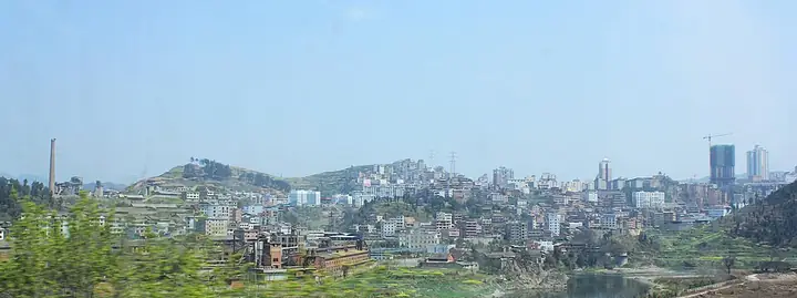
Photo adjustments
Full-frame source proportionally resized and converted to WebP for display. No subject alteration. Source-supplied marks and edits remain; cards may crop the view.
- Administrative area
- County-level city · 县级市
- Part of
- Qiandongnan Miao and Dong Autonomous Prefecture
- Chinese name
- 凯里市
- Local areas
- County-level city guide
Area & population
- Area in the source
- 1,570.00 km²
- Population · 2020 census
- 709,057
- Administrative seat
- Dashizi Subdistrict
Source: cited geographic source, as of the dates shown.
Setting and landscape
Kaili borders Taijiang (台江) to the east, Majiang (麻江) and Fuquan (福泉) to the west, Leishan (雷山) and Danzhai (丹寨) to the south, and Huangping (黄平) to the north. The land slopes from the southwest, where Goumoye Peak (够末也峰) reaches 1,447 m, down to 529 m where the Qingshui River (清水江) leaves the city. A ridge running over Xianglu Mountain (香炉山) divides the Chong'an River (重安江) from the Qingshui, and karst landforms are typical. Besides Xianglu Mountain, the main natural sights are Jinquan Lake (金泉湖) and a number of karst caves.
History
The Ming set up a Kaili chieftaincy in 1372, and in 1494 the Qingping chieftaincy was made Qingping County (清平县). Because Shandong had a county of the same name, it was renamed Lushan (炉山县) in 1913, after Xianglu Mountain. Lushan became the prefecture capital when Qiandongnan was created in 1956. In 1958 Lushan, Leishan, Danzhai and Majiang were merged into a single Kaili County; the others were split off again in 1961–62, and Kaili County became Kaili City in January 1984. In 2012 the Majiang towns of Xiasi (下司) and Bibo (碧波) came under the city's administration.
What to see
Wanshou Palace (万寿宫), the old Jiangxi merchants' guild hall in Ximen subdistrict, was founded in 1607; its stage and main hall survive, and it has been a provincial protected site since 2006. In 1938 local youth founded an anti-Japanese support association there. Other provincial sites include the tomb and shrine of Sun Ying'ao (孙应鳌) and the stele at the Ganangxiang lusheng ground (甘囊香芦笙堂).
Kaili calls itself a "home of a hundred festivals". The largest is the Ganangxiang lusheng festival at Zhouxi (舟溪), held from the 18th to the 20th of the first lunar month, with reed-pipe playing, bullfights and horse races; the gathering has a 400-year history and is on the Guizhou provincial intangible-heritage list. In Xiasi, the market is the largest of any town in Kaili and has run for about a century, with rice noodles, fried tofu and sticky-rice cakes among the stalls.
Food and local products
The craft of Kaili sour soup fish (凯里酸汤鱼) entered the national intangible-heritage list in 2021. It is cooked as a hotpot. White sour soup is rice water made from glutinous rice and left to ferment for five or six days in a jar smoked with burnt rice straw; red sour soup is fresh tomato and red chilli fermented for five or six months. The listing links the habit to using sourness in place of salt.
Highlights
- Wanshou Palace 万寿宫: Jiangxi guild hall founded in 1607; provincial protected site since 2006.
- Ganangxiang lusheng festival 甘囊香芦笙节: Miao reed-pipe gathering at Zhouxi, 18th–20th of the first lunar month, with a 400-year history.
- Xiasi market 下司大集: The largest town market in Kaili, running for about a century.
- Kaili sour soup fish 凯里酸汤鱼: Hotpot in fermented white or red sour soup; national intangible heritage since 2021.
Sources for this guide
凯里市人民政府- 凯里市自然地理 · Kaili City People's Government
凯里市人民政府- 凯里市历史沿革 · Kaili City People's Government
凯里市人民政府- 民族节日·甘囊香芦笙节 · Kaili City People's Government
凯里酸汤鱼制作技艺 · China Intangible Cultural Heritage Network (ihchina.cn)
凯里市人民政府- 万寿宫:从商埠会馆到革命遗址的400年 · Kaili City People's Government
凯里市人民政府- 凯里市文物保护单位 · Kaili City People's Government
凯里市人民政府- 临近年关,来凯里下司,赶百年大集→ · Kaili City People's Government (reposted from Xindong Kaili)
凯里市 - 维基百科,自由的百科全书 · Wikipedia (Chinese) · CC BY-SA 4.0
Original English written from the listed sources and checked sentence by sentence against quoted extracts by a separate reviewer. Updated 2026-09-24.
Explore Kaili City
Core places to explore, with English and Chinese names.
Places to explore around Kaili City
 Xiasi Ancient Town ·
 Plan your visit
Getting there
Kaili City covers the centre of Qiandongnan Miao and Dong Autonomous Prefecture. Search for 凯里市 in a map app to find stations and your accommodation.
Where to stay →Build your route
Start with Xiasi Ancient Town. The linked place guides have entrance and visit details.
Continue with Qiandongnan Miao and Dong Autonomous Prefecture →More in Qiandongnan Miao and Dong Autonomous Prefecture
Sources & geographic information
Administrative names and parent areas: Official geographic directory · Reference date 2026-09-06.
Some facts checked against 凯里市 — Wikipedia contributors, CC BY-SA 4.0.
Photo: Xiasi Ancient Town · Source photographer · License not provided. EXIF orientation normalized; resized without changing aspect ratio; converted to WebP. No subject edits.
Map data © OpenStreetMap contributors. Pins mark approximate centres, not entrances or boundaries.